Pirep is a free, collaborative database of all public and private airports. All pilots are welcome to contribute their local knowledge to any airport, no registration required.
Undocumented
METAR / TAF
Edit Tags
No upcoming events. Is anything happening here soon?
Airport Statistics
- Crew car availability
- Landing & tie-down fees
- Airport photos
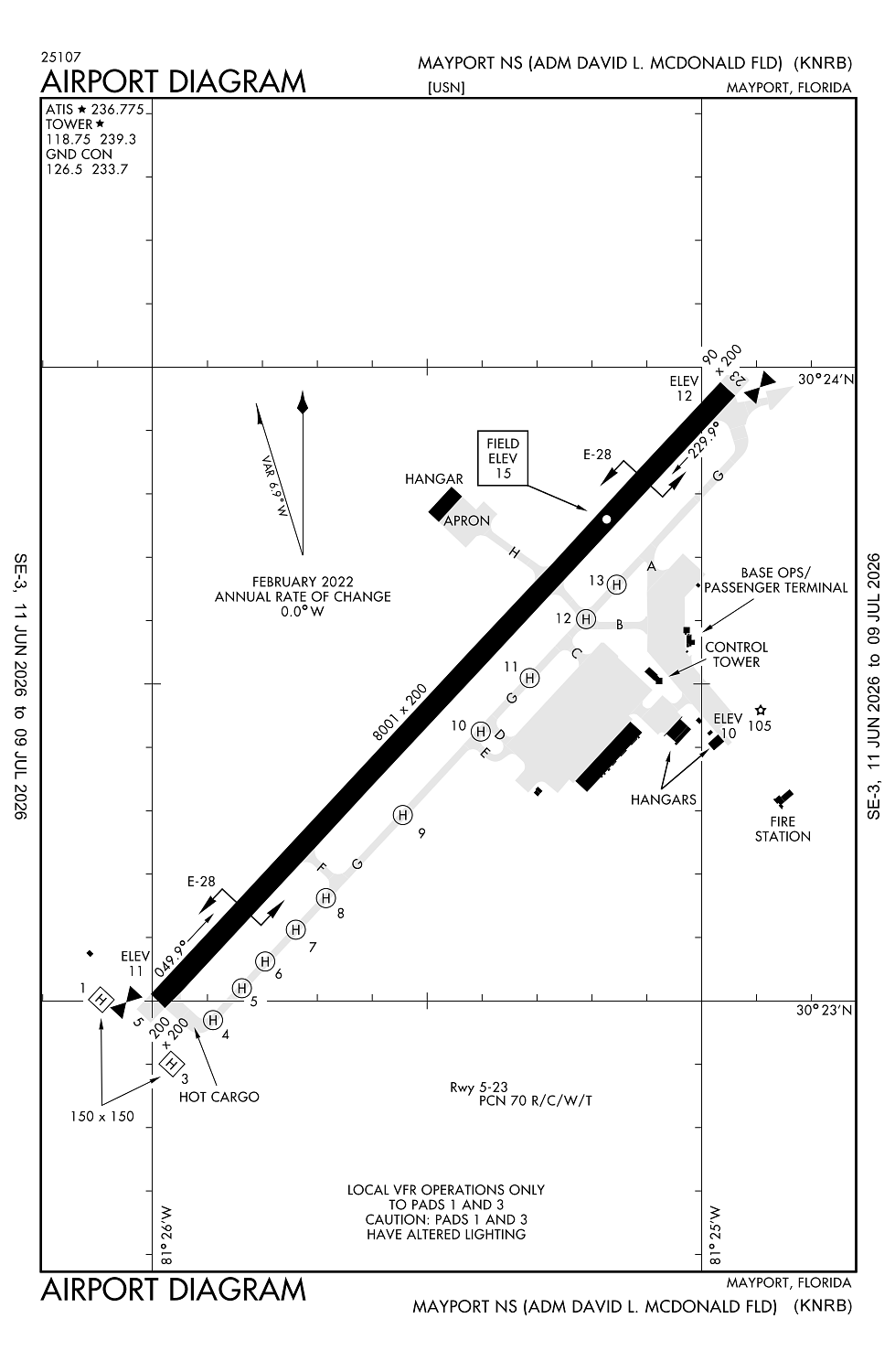
Location:
Mayport, FL
Elevation:
14ft
Sectional:
Jacksonville
Fuel:
J5 (prices)
Runway 05/23:
8,001ft
Access: Private to everyone
This is a military facility.
Current Weather — VFR
-
Weather data is strictly informational and not for flight planning purposes.
-
METAR2026-07-16 12:52:00 EDT
Ceiling: 25,000ft Wind: 340° @ 4kt Temperature: 91°F Dewpoint: 73°F Weather: N/A Visbility: 10SM Clouds: Few @ 4,000ft, Broken @ 25,000ft Raw:METAR KNRB 161652Z 34004KT 10SM FEW040 BKN250 33/23 A3006 RMK AO2 SLP177 T03280233 $ -
TAF2026-07-16 11:00:00 EDT – 2026-07-16 14:00:00 EDT
Ceiling: 25,000ft Wind: 280° @ 8kt Weather: N/A Visbility: 6SM Clouds: Scattered @ 4,000ft, Broken @ 25,000ft Raw:TAF KNRB 161500Z 1615/1715 28008KT 9999 SCT040 BKN250 QNH3001INS FM161800 11010G15KT 9999 VCTS SCT035CB BKN250 QNH2994INS TEMPO 1620/1701 VRB20G30KT 3200 TSRA BKN010 OVC030CB FM170200 VRB05KT 9999 FEW100 BKN250 QNH2997INS TX33/1618Z TN25/1711Z FN20022 -
TAF2026-07-16 14:00:00 EDT – 2026-07-16 22:00:00 EDT
Ceiling: 25,000ft Wind: 110° @ 10kt, gusts 15kt Weather: Thunderstorm in vicinity Visbility: 6SM Clouds: Scattered @ 3,500ft, Broken @ 25,000ft Raw:TAF KNRB 161500Z 1615/1715 28008KT 9999 SCT040 BKN250 QNH3001INS FM161800 11010G15KT 9999 VCTS SCT035CB BKN250 QNH2994INS TEMPO 1620/1701 VRB20G30KT 3200 TSRA BKN010 OVC030CB FM170200 VRB05KT 9999 FEW100 BKN250 QNH2997INS TX33/1618Z TN25/1711Z FN20022 -
TAF2026-07-16 16:00:00 EDT – 2026-07-16 21:00:00 EDT
Ceiling: 1,000ft Wind: Variable, gusts 30kt Weather: Thunderstorm rain Visbility: 1SM Clouds: Broken @ 1,000ft, Overcast @ 3,000ft Raw:TAF KNRB 161500Z 1615/1715 28008KT 9999 SCT040 BKN250 QNH3001INS FM161800 11010G15KT 9999 VCTS SCT035CB BKN250 QNH2994INS TEMPO 1620/1701 VRB20G30KT 3200 TSRA BKN010 OVC030CB FM170200 VRB05KT 9999 FEW100 BKN250 QNH2997INS TX33/1618Z TN25/1711Z FN20022 -
TAF2026-07-16 22:00:00 EDT – 2026-07-17 11:00:00 EDT
Ceiling: 25,000ft Wind: Variable Weather: N/A Visbility: 6SM Clouds: Few @ 10,000ft, Broken @ 25,000ft Raw:TAF KNRB 161500Z 1615/1715 28008KT 9999 SCT040 BKN250 QNH3001INS FM161800 11010G15KT 9999 VCTS SCT035CB BKN250 QNH2994INS TEMPO 1620/1701 VRB20G30KT 3200 TSRA BKN010 OVC030CB FM170200 VRB05KT 9999 FEW100 BKN250 QNH2997INS TX33/1618Z TN25/1711Z FN20022
Click/tap to add an annotation marker to the map
No webcams added yet.
Remarks
- Customs/agriculture/img avbl for acft with 30 psgrs or less; mon-fri excp hols 0800-1700. other times 48 hr ppr.
- Jasu: 1(nc-8) 1(gtc-85) 1(a/ncpp-105).
- Tsnt/hung ordnance/divert alert; organic air-launched weapons safing cpbly na; tsnt maint na; limited tsnt prk avbl.
- Rstd: 24 hr ppr/civil acft lndg permit; pcn exceeding 34 rqr 72 hr ppr - base ops dsn 270-6130/31, c904-270-6130/31. participating acft only durg spl lcl ops.
- Caution: lgt to hvy bird act on and in vcnty of arpt. vessels with masts to 196 ft fqtly berthed 800 ft left of rwy 23 thld. large vessels with masts up to 150 ft fqtly transit the river chan adj to apch end rwy 23 dur final apch.
Comments