Pirep is a free, collaborative database of all public and private airports. All pilots are welcome to contribute their local knowledge to any airport, no registration required.

Public
Undocumented
METAR / TAF
Edit Tags
No upcoming events. Is anything happening here soon?
Airport Statistics
- Landing & tie-down fees
- Tags
- Transient parking location
Location:
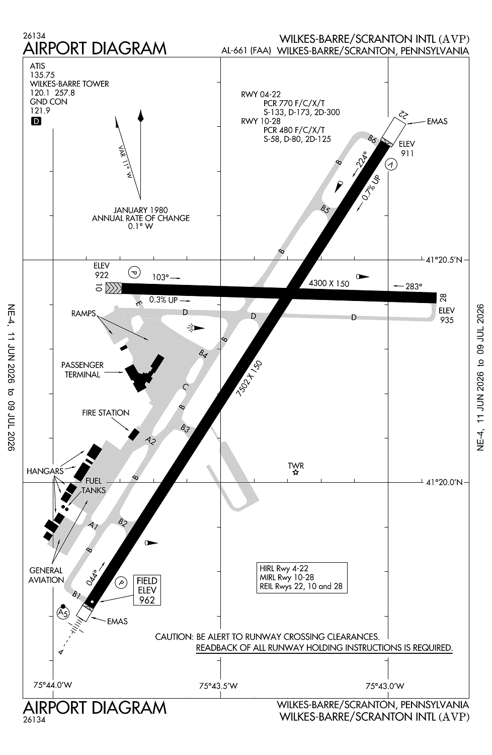
Wilkes Barre/Scranton, PA
Elevation:
961ft
Sectional:
New York
Activation date:
Jan 1947
Fuel:
100LL, A (prices)
Runway 04/22:
7,502ft
Runway 10/28:
4,300ft
Access: Open to the public
Current Weather — MVFR
-
Weather data is strictly informational and not for flight planning purposes.
-
METAR2026-07-21 10:54:00 EDT
Ceiling: 1,700ft Wind: 010° @ 3kt Temperature: 73°F Dewpoint: 69°F Weather: N/A Visbility: 10SM Clouds: Broken @ 1,700ft, Broken @ 2,300ft, Overcast @ 3,000ft Raw:METAR KAVP 211454Z 01003KT 10SM BKN017 BKN023 OVC030 23/21 A2981 RMK AO2 SLP085 T02280206 58011 -
TAF2026-07-21 11:00:00 EDT – 2026-07-21 14:00:00 EDT
Ceiling: 1,800ft Wind: Variable Weather: N/A Visbility: 6SM Clouds: Broken @ 1,800ft Raw:TAF KAVP 211513Z 2115/2212 VRB06KT P6SM BKN018 FM211800 19009KT 6SM -SHRA BKN035 TEMPO 2120/2123 3SM -TSRA OVC025CB FM220000 22004KT 6SM -SHRA BR BKN035 FM220400 20006KT P6SM BKN025 FM220600 21005KT P6SM BKN015 -
TAF2026-07-21 14:00:00 EDT – 2026-07-21 20:00:00 EDT
Ceiling: 3,500ft Wind: 190° @ 9kt Weather: Light rain showers Visbility: 6SM Clouds: Broken @ 3,500ft Raw:TAF KAVP 211513Z 2115/2212 VRB06KT P6SM BKN018 FM211800 19009KT 6SM -SHRA BKN035 TEMPO 2120/2123 3SM -TSRA OVC025CB FM220000 22004KT 6SM -SHRA BR BKN035 FM220400 20006KT P6SM BKN025 FM220600 21005KT P6SM BKN015 -
TAF2026-07-21 16:00:00 EDT – 2026-07-21 19:00:00 EDT
Ceiling: 2,500ft Wind: 000° @ kt Weather: Light thunderstorm rain Visbility: 3SM Clouds: Overcast @ 2,500ft Raw:TAF KAVP 211513Z 2115/2212 VRB06KT P6SM BKN018 FM211800 19009KT 6SM -SHRA BKN035 TEMPO 2120/2123 3SM -TSRA OVC025CB FM220000 22004KT 6SM -SHRA BR BKN035 FM220400 20006KT P6SM BKN025 FM220600 21005KT P6SM BKN015 -
TAF2026-07-21 20:00:00 EDT – 2026-07-22 00:00:00 EDT
Ceiling: 3,500ft Wind: 220° @ 4kt Weather: Light rain showers, mist Visbility: 6SM Clouds: Broken @ 3,500ft Raw:TAF KAVP 211513Z 2115/2212 VRB06KT P6SM BKN018 FM211800 19009KT 6SM -SHRA BKN035 TEMPO 2120/2123 3SM -TSRA OVC025CB FM220000 22004KT 6SM -SHRA BR BKN035 FM220400 20006KT P6SM BKN025 FM220600 21005KT P6SM BKN015 -
TAF2026-07-22 00:00:00 EDT – 2026-07-22 02:00:00 EDT
Ceiling: 2,500ft Wind: 200° @ 6kt Weather: N/A Visbility: 6SM Clouds: Broken @ 2,500ft Raw:TAF KAVP 211513Z 2115/2212 VRB06KT P6SM BKN018 FM211800 19009KT 6SM -SHRA BKN035 TEMPO 2120/2123 3SM -TSRA OVC025CB FM220000 22004KT 6SM -SHRA BR BKN035 FM220400 20006KT P6SM BKN025 FM220600 21005KT P6SM BKN015 -
TAF2026-07-22 02:00:00 EDT – 2026-07-22 08:00:00 EDT
Ceiling: 1,500ft Wind: 210° @ 5kt Weather: N/A Visbility: 6SM Clouds: Broken @ 1,500ft Raw:TAF KAVP 211513Z 2115/2212 VRB06KT P6SM BKN018 FM211800 19009KT 6SM -SHRA BKN035 TEMPO 2120/2123 3SM -TSRA OVC025CB FM220000 22004KT 6SM -SHRA BR BKN035 FM220400 20006KT P6SM BKN025 FM220600 21005KT P6SM BKN015
Click/tap to add an annotation marker to the map
No webcams added yet.
Remarks
- Existed prior to reqmt for airspace deter.
- Index "c" arff equipment available upon request call 570-602-2040.
- Deer & birds on & invof arpt.
- Ry 28 unlgtd high terrain trees: 1155 ft msl .91 mi east aer 28; 1463 ft msl 1.49 mi east-southeast aer 28; 1667 ft msl 2.25 mi east aer 28; 1920 ft msl 2.84 mi east aer 28.
- Unlgtd tower 1130 ft msl (20 ft agl) 1.3 mi east aer 28; unlgtd tower 1463 ft msl (20 ft agl) 1.7 mi east aer 28; unlgtd tower 1652 ft msl (20 ft agl) 2.4 mi east aer 28.
Comments