Pirep is a free, collaborative database of all public and private airports. All pilots are welcome to contribute their local knowledge to any airport, no registration required.
Public
Undocumented
METAR / TAF
Edit Tags
No upcoming events. Is anything happening here soon?
Airport Statistics
- Landing & tie-down fees
- Tags
- General description
Location:
Philadelphia, PA
Elevation:
35ft
Sectional:
Washington
Activation date:
Oct 1940
Fuel:
100LL, A (prices)
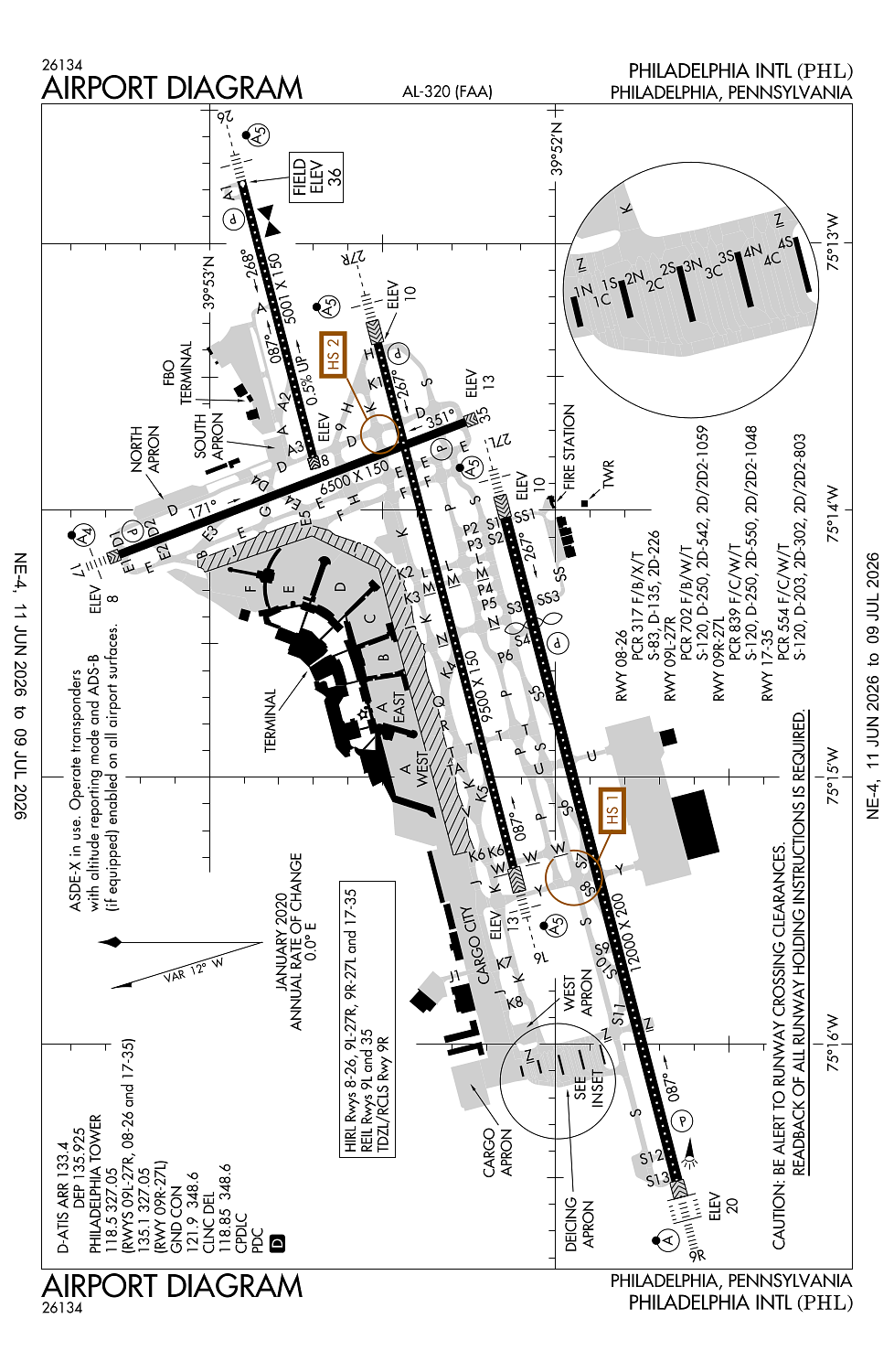
Runway 09R/27L:
12,000ft
Runway 09L/27R:
9,500ft
Runway 17/35:
6,500ft
Runway 08/26:
5,001ft
Access: Open to the public
Current Weather — VFR
-
Weather data is strictly informational and not for flight planning purposes.
-
METAR2026-07-21 07:27:00 EDT
Ceiling: 4,500ft Wind: 160° @ 8kt Temperature: 75°F Dewpoint: 71°F Weather: N/A Visbility: 10SM Clouds: Scattered @ 2,300ft, Broken @ 4,500ft, Overcast @ 11,000ft Raw:SPECI KPHL 211127Z 16008KT 10SM SCT023 BKN045 OVC110 24/22 A2985 RMK AO2 SCT V BKN T02440217 $ -
TAF2026-07-21 08:00:00 EDT – 2026-07-21 10:00:00 EDT
Ceiling: 2,000ft Wind: 160° @ 8kt Weather: Showers in vicinity Visbility: 6SM Clouds: Broken @ 2,000ft, Overcast @ 4,000ft Raw:TAF KPHL 211120Z 2112/2218 16008KT P6SM VCSH BKN020 OVC040 FM211400 17010KT P6SM VCSH SCT015 OVC030 PROB30 2114/2116 5SM -TSRA BR OVC020CB FM211600 20010KT P6SM SCT025 BKN035 PROB30 2116/2120 4SM TSRA BR OVC020CB FM212000 23012KT 4SM SHRA BR VCTS OVC050CB TEMPO 2121/2201 30020G40KT 2SM +TSRA OVC030CB FM220100 20010KT 4SM SHRA BR VCTS SCT025 OVC050CB FM220400 22008KT P6SM VCSH BKN025 -
TAF2026-07-21 10:00:00 EDT – 2026-07-21 12:00:00 EDT
Ceiling: 2,000ft Wind: 000° @ kt Weather: Light thunderstorm rain, mist Visbility: 5SM Clouds: Overcast @ 2,000ft Raw:TAF KPHL 211120Z 2112/2218 16008KT P6SM VCSH BKN020 OVC040 FM211400 17010KT P6SM VCSH SCT015 OVC030 PROB30 2114/2116 5SM -TSRA BR OVC020CB FM211600 20010KT P6SM SCT025 BKN035 PROB30 2116/2120 4SM TSRA BR OVC020CB FM212000 23012KT 4SM SHRA BR VCTS OVC050CB TEMPO 2121/2201 30020G40KT 2SM +TSRA OVC030CB FM220100 20010KT 4SM SHRA BR VCTS SCT025 OVC050CB FM220400 22008KT P6SM VCSH BKN025 -
TAF2026-07-21 10:00:00 EDT – 2026-07-21 12:00:00 EDT
Ceiling: 3,000ft Wind: 170° @ 10kt Weather: Showers in vicinity Visbility: 6SM Clouds: Scattered @ 1,500ft, Overcast @ 3,000ft Raw:TAF KPHL 211120Z 2112/2218 16008KT P6SM VCSH BKN020 OVC040 FM211400 17010KT P6SM VCSH SCT015 OVC030 PROB30 2114/2116 5SM -TSRA BR OVC020CB FM211600 20010KT P6SM SCT025 BKN035 PROB30 2116/2120 4SM TSRA BR OVC020CB FM212000 23012KT 4SM SHRA BR VCTS OVC050CB TEMPO 2121/2201 30020G40KT 2SM +TSRA OVC030CB FM220100 20010KT 4SM SHRA BR VCTS SCT025 OVC050CB FM220400 22008KT P6SM VCSH BKN025 -
TAF2026-07-21 12:00:00 EDT – 2026-07-21 16:00:00 EDT
Ceiling: 2,000ft Wind: 000° @ kt Weather: Thunderstorm rain, mist Visbility: 4SM Clouds: Overcast @ 2,000ft Raw:TAF KPHL 211120Z 2112/2218 16008KT P6SM VCSH BKN020 OVC040 FM211400 17010KT P6SM VCSH SCT015 OVC030 PROB30 2114/2116 5SM -TSRA BR OVC020CB FM211600 20010KT P6SM SCT025 BKN035 PROB30 2116/2120 4SM TSRA BR OVC020CB FM212000 23012KT 4SM SHRA BR VCTS OVC050CB TEMPO 2121/2201 30020G40KT 2SM +TSRA OVC030CB FM220100 20010KT 4SM SHRA BR VCTS SCT025 OVC050CB FM220400 22008KT P6SM VCSH BKN025 -
TAF2026-07-21 12:00:00 EDT – 2026-07-21 16:00:00 EDT
Ceiling: 3,500ft Wind: 200° @ 10kt Weather: N/A Visbility: 6SM Clouds: Scattered @ 2,500ft, Broken @ 3,500ft Raw:TAF KPHL 211120Z 2112/2218 16008KT P6SM VCSH BKN020 OVC040 FM211400 17010KT P6SM VCSH SCT015 OVC030 PROB30 2114/2116 5SM -TSRA BR OVC020CB FM211600 20010KT P6SM SCT025 BKN035 PROB30 2116/2120 4SM TSRA BR OVC020CB FM212000 23012KT 4SM SHRA BR VCTS OVC050CB TEMPO 2121/2201 30020G40KT 2SM +TSRA OVC030CB FM220100 20010KT 4SM SHRA BR VCTS SCT025 OVC050CB FM220400 22008KT P6SM VCSH BKN025 -
TAF2026-07-21 16:00:00 EDT – 2026-07-21 21:00:00 EDT
Ceiling: 5,000ft Wind: 230° @ 12kt Weather: Rain showers, mist, thunderstorm in vicinity Visbility: 4SM Clouds: Overcast @ 5,000ft Raw:TAF KPHL 211120Z 2112/2218 16008KT P6SM VCSH BKN020 OVC040 FM211400 17010KT P6SM VCSH SCT015 OVC030 PROB30 2114/2116 5SM -TSRA BR OVC020CB FM211600 20010KT P6SM SCT025 BKN035 PROB30 2116/2120 4SM TSRA BR OVC020CB FM212000 23012KT 4SM SHRA BR VCTS OVC050CB TEMPO 2121/2201 30020G40KT 2SM +TSRA OVC030CB FM220100 20010KT 4SM SHRA BR VCTS SCT025 OVC050CB FM220400 22008KT P6SM VCSH BKN025 -
TAF2026-07-21 17:00:00 EDT – 2026-07-21 21:00:00 EDT
Ceiling: 3,000ft Wind: 300° @ 20kt, gusts 40kt Weather: Heavy thunderstorm rain Visbility: 2SM Clouds: Overcast @ 3,000ft Raw:TAF KPHL 211120Z 2112/2218 16008KT P6SM VCSH BKN020 OVC040 FM211400 17010KT P6SM VCSH SCT015 OVC030 PROB30 2114/2116 5SM -TSRA BR OVC020CB FM211600 20010KT P6SM SCT025 BKN035 PROB30 2116/2120 4SM TSRA BR OVC020CB FM212000 23012KT 4SM SHRA BR VCTS OVC050CB TEMPO 2121/2201 30020G40KT 2SM +TSRA OVC030CB FM220100 20010KT 4SM SHRA BR VCTS SCT025 OVC050CB FM220400 22008KT P6SM VCSH BKN025 -
TAF2026-07-21 21:00:00 EDT – 2026-07-22 00:00:00 EDT
Ceiling: 5,000ft Wind: 200° @ 10kt Weather: Rain showers, mist, thunderstorm in vicinity Visbility: 4SM Clouds: Scattered @ 2,500ft, Overcast @ 5,000ft Raw:TAF KPHL 211120Z 2112/2218 16008KT P6SM VCSH BKN020 OVC040 FM211400 17010KT P6SM VCSH SCT015 OVC030 PROB30 2114/2116 5SM -TSRA BR OVC020CB FM211600 20010KT P6SM SCT025 BKN035 PROB30 2116/2120 4SM TSRA BR OVC020CB FM212000 23012KT 4SM SHRA BR VCTS OVC050CB TEMPO 2121/2201 30020G40KT 2SM +TSRA OVC030CB FM220100 20010KT 4SM SHRA BR VCTS SCT025 OVC050CB FM220400 22008KT P6SM VCSH BKN025 -
TAF2026-07-22 00:00:00 EDT – 2026-07-22 14:00:00 EDT
Ceiling: 2,500ft Wind: 220° @ 8kt Weather: Showers in vicinity Visbility: 6SM Clouds: Broken @ 2,500ft Raw:TAF KPHL 211120Z 2112/2218 16008KT P6SM VCSH BKN020 OVC040 FM211400 17010KT P6SM VCSH SCT015 OVC030 PROB30 2114/2116 5SM -TSRA BR OVC020CB FM211600 20010KT P6SM SCT025 BKN035 PROB30 2116/2120 4SM TSRA BR OVC020CB FM212000 23012KT 4SM SHRA BR VCTS OVC050CB TEMPO 2121/2201 30020G40KT 2SM +TSRA OVC030CB FM220100 20010KT 4SM SHRA BR VCTS SCT025 OVC050CB FM220400 22008KT P6SM VCSH BKN025
Click/tap to add an annotation marker to the map
No webcams added yet.
Remarks
- Birds on & invof arpt.
- Rwys 27l, 27r & 35 ship chnl (delaware river) max hgt of ships 189 ft. rwy 26 ship chnl (schuylkill) max hgt of ships 149 ft.
- Arpt is lctd in a noise sensitive area. airport noise abatement tkof procs are to be used.
- Tcas equipped acft-tcas alert may be caused by transponder equipped ships lctd phl naval base 3 nm e.
- Unlgtd stack 288 ft msl (271 ft agl) 2.3 nm sw of arpt.
Comments