Pirep is a free, collaborative database of all public and private airports. All pilots are welcome to contribute their local knowledge to any airport, no registration required.

Public
Undocumented
METAR / TAF
Edit Tags
No upcoming events. Is anything happening here soon?
Airport Statistics
- Airport map annotations
- Crew car availability
- Transient parking location
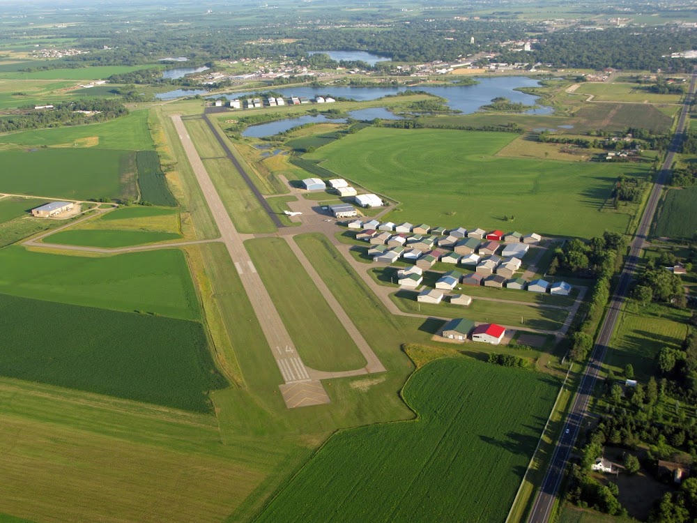
Location:
New Richmond, WI
Elevation:
997ft
Sectional:
Green Bay
Activation date:
Jul 1964
Fuel:
100LL, A (prices)
Runway 14/32:
5,507ft
Runway 04/22:
2,006ft
Runway H1:
40ft
Access: Open to the public
Current Weather — MVFR
-
Weather data is strictly informational and not for flight planning purposes.
-
METAR2026-07-16 03:30:00 CDT
Ceiling: 2,700ft Wind: 070° @ 3kt Temperature: 66°F Dewpoint: 59°F Weather: Haze Visbility: 4SM Clouds: Overcast @ 2,700ft Raw:METAR KRNH 160830Z AUTO 07003KT 4SM HZ OVC027 19/15 A3011 RMK AO2 T01930152 -
TAF2026-07-16 04:00:00 CDT – 2026-07-16 07:00:00 CDT
Ceiling: 2,500ft Wind: 040° @ 3kt Weather: Smoke Visbility: 3SM Clouds: Overcast @ 2,500ft Raw:TAF KRNH 160914Z 1609/1706 04003KT 3SM FU OVC025 FM161200 08002KT 3SM FU BKN022 FM161400 12005KT 6SM FU SCT050 FM170000 16003KT P6SM SCT100 -
TAF2026-07-16 07:00:00 CDT – 2026-07-16 09:00:00 CDT
Ceiling: 2,200ft Wind: 080° @ 2kt Weather: Smoke Visbility: 3SM Clouds: Broken @ 2,200ft Raw:TAF KRNH 160914Z 1609/1706 04003KT 3SM FU OVC025 FM161200 08002KT 3SM FU BKN022 FM161400 12005KT 6SM FU SCT050 FM170000 16003KT P6SM SCT100 -
TAF2026-07-16 09:00:00 CDT – 2026-07-16 19:00:00 CDT
Ceiling: Sky clear Wind: 120° @ 5kt Weather: Smoke Visbility: 6SM Clouds: Scattered @ 5,000ft Raw:TAF KRNH 160914Z 1609/1706 04003KT 3SM FU OVC025 FM161200 08002KT 3SM FU BKN022 FM161400 12005KT 6SM FU SCT050 FM170000 16003KT P6SM SCT100 -
TAF2026-07-16 19:00:00 CDT – 2026-07-17 01:00:00 CDT
Ceiling: Sky clear Wind: 160° @ 3kt Weather: N/A Visbility: 6SM Clouds: Scattered @ 10,000ft Raw:TAF KRNH 160914Z 1609/1706 04003KT 3SM FU OVC025 FM161200 08002KT 3SM FU BKN022 FM161400 12005KT 6SM FU SCT050 FM170000 16003KT P6SM SCT100
Click/tap to add an annotation marker to the map
No webcams added yet.
Remarks
- Deer & birds on & invof arpt.
- Aerobatic practice area 4 nm ne of arpt.
- Ultralight activity on & invof arpt.
- Seaplane traffic adjacent to south side of arpt.
- Turbo-jet touch & go not authorized.
- Bright lgts fm ball fields 1/2 mi south durg evenings may thru sep.
- Gco avbl on freq 121.725 thru minneapolis apch ctl.
- Automobile and pedestrian access onto arpt property restricted by security fencing and gates fm 2200-0600. ctc amgr 715-246-7735 for access instructions.
Comments