Pirep is a free, collaborative database of all public and private airports. All pilots are welcome to contribute their local knowledge to any airport, no registration required.


Public
Undocumented
METAR / TAF
Edit Tags
No upcoming events. Is anything happening here soon?
Airport Statistics
- Landing & tie-down fees
- Fuel pump location
- Transient parking location
Location:
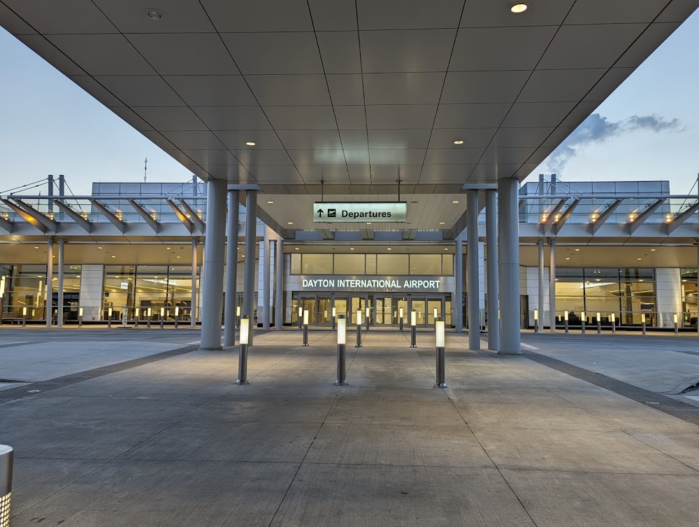
Dayton, OH
Elevation:
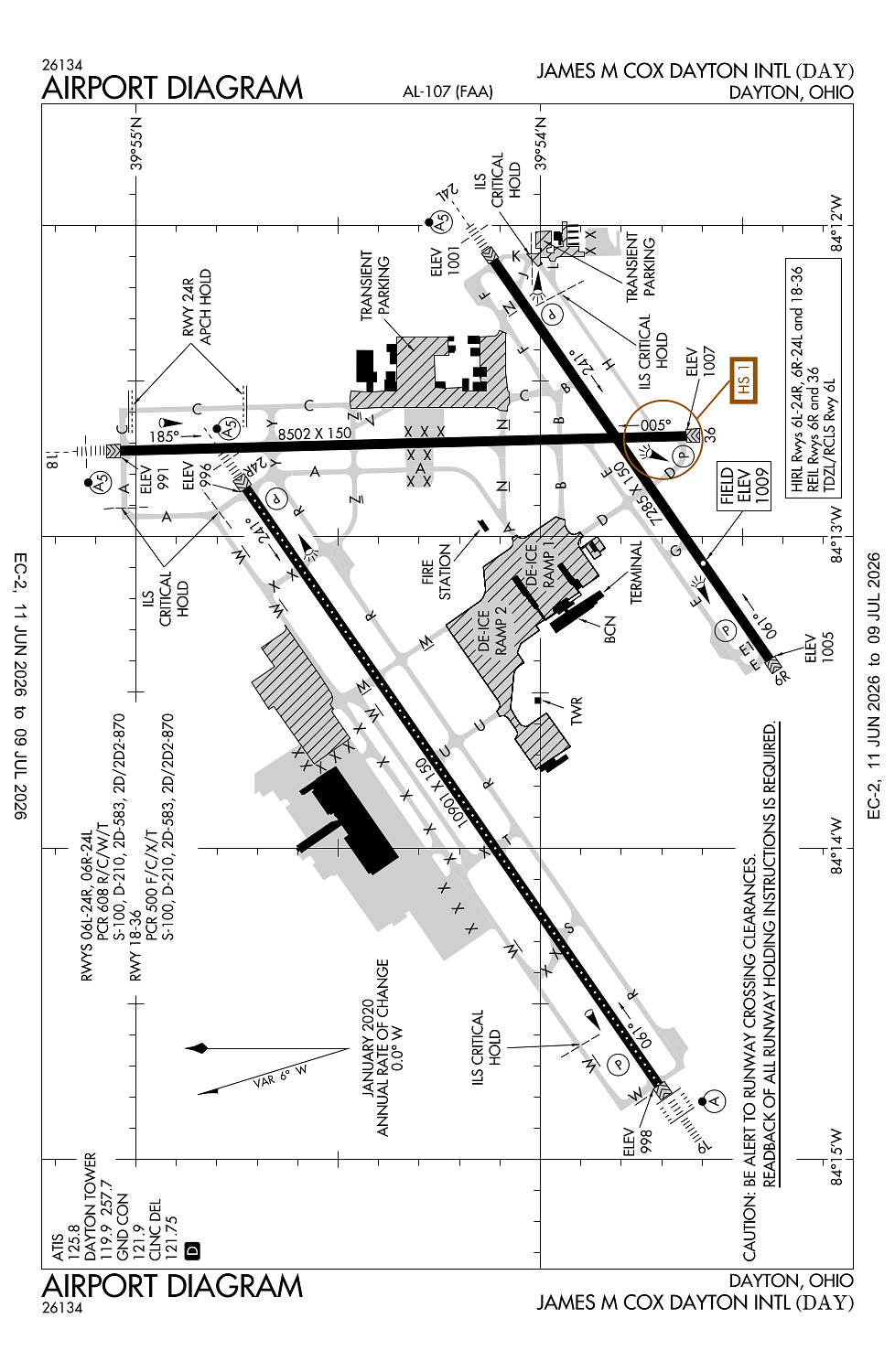
1,009ft
Sectional:
Cincinnati
Activation date:
Oct 1937
Fuel:
100, A (prices)
Runway 06L/24R:
10,901ft
Runway 18/36:
8,502ft
Runway 06R/24L:
7,285ft
Access: Open to the public
Current Weather — VFR
-
Weather data is strictly informational and not for flight planning purposes.
-
METAR2026-07-21 07:56:00 EDT
Ceiling: 11,000ft Wind: 230° @ 14kt, gusts 23kt Temperature: 73°F Dewpoint: 69°F Weather: Thunderstorm Visbility: 7SM Clouds: Scattered @ 7,500ft, Broken @ 11,000ft, Overcast @ 18,000ft Raw:METAR KDAY 211156Z 23014G23KT 7SM TS SCT075CB BKN110 OVC180 23/21 A2975 RMK AO2 TSB53 SLP063 OCNL LTGICCCCG NW TS NW MOV SE T02330211 10233 20222 56012 $ -
TAF2026-07-21 08:00:00 EDT – 2026-07-21 10:00:00 EDT
Ceiling: 3,500ft Wind: 240° @ 12kt, gusts 20kt Weather: Light rain showers Visbility: 6SM Clouds: Overcast @ 3,500ft Raw:TAF KDAY 211210Z 2112/2212 24012G20KT P6SM -SHRA OVC035 TEMPO 2112/2114 23014G28KT 4SM -TSRA OVC025CB FM211400 24014G22KT P6SM BKN035 PROB30 2117/2123 4SM -TSRA OVC025CB FM212300 28014G22KT P6SM SCT040 BKN150 FM220200 32008KT P6SM SCT150 -
TAF2026-07-21 08:00:00 EDT – 2026-07-21 10:00:00 EDT
Ceiling: 2,500ft Wind: 230° @ 14kt, gusts 28kt Weather: Light thunderstorm rain Visbility: 4SM Clouds: Overcast @ 2,500ft Raw:TAF KDAY 211210Z 2112/2212 24012G20KT P6SM -SHRA OVC035 TEMPO 2112/2114 23014G28KT 4SM -TSRA OVC025CB FM211400 24014G22KT P6SM BKN035 PROB30 2117/2123 4SM -TSRA OVC025CB FM212300 28014G22KT P6SM SCT040 BKN150 FM220200 32008KT P6SM SCT150 -
TAF2026-07-21 10:00:00 EDT – 2026-07-21 19:00:00 EDT
Ceiling: 3,500ft Wind: 240° @ 14kt, gusts 22kt Weather: N/A Visbility: 6SM Clouds: Broken @ 3,500ft Raw:TAF KDAY 211210Z 2112/2212 24012G20KT P6SM -SHRA OVC035 TEMPO 2112/2114 23014G28KT 4SM -TSRA OVC025CB FM211400 24014G22KT P6SM BKN035 PROB30 2117/2123 4SM -TSRA OVC025CB FM212300 28014G22KT P6SM SCT040 BKN150 FM220200 32008KT P6SM SCT150 -
TAF2026-07-21 13:00:00 EDT – 2026-07-21 19:00:00 EDT
Ceiling: 2,500ft Wind: 000° @ kt Weather: Light thunderstorm rain Visbility: 4SM Clouds: Overcast @ 2,500ft Raw:TAF KDAY 211210Z 2112/2212 24012G20KT P6SM -SHRA OVC035 TEMPO 2112/2114 23014G28KT 4SM -TSRA OVC025CB FM211400 24014G22KT P6SM BKN035 PROB30 2117/2123 4SM -TSRA OVC025CB FM212300 28014G22KT P6SM SCT040 BKN150 FM220200 32008KT P6SM SCT150 -
TAF2026-07-21 19:00:00 EDT – 2026-07-21 22:00:00 EDT
Ceiling: 15,000ft Wind: 280° @ 14kt, gusts 22kt Weather: N/A Visbility: 6SM Clouds: Scattered @ 4,000ft, Broken @ 15,000ft Raw:TAF KDAY 211210Z 2112/2212 24012G20KT P6SM -SHRA OVC035 TEMPO 2112/2114 23014G28KT 4SM -TSRA OVC025CB FM211400 24014G22KT P6SM BKN035 PROB30 2117/2123 4SM -TSRA OVC025CB FM212300 28014G22KT P6SM SCT040 BKN150 FM220200 32008KT P6SM SCT150 -
TAF2026-07-21 22:00:00 EDT – 2026-07-22 08:00:00 EDT
Ceiling: Sky clear Wind: 320° @ 8kt Weather: N/A Visbility: 6SM Clouds: Scattered @ 15,000ft Raw:TAF KDAY 211210Z 2112/2212 24012G20KT P6SM -SHRA OVC035 TEMPO 2112/2114 23014G28KT 4SM -TSRA OVC025CB FM211400 24014G22KT P6SM BKN035 PROB30 2117/2123 4SM -TSRA OVC025CB FM212300 28014G22KT P6SM SCT040 BKN150 FM220200 32008KT P6SM SCT150
Click/tap to add an annotation marker to the map
No webcams added yet.
Remarks
- Runups prohibited on rwy 24l hold pad.
- Twy z, twy t, & twy s btn rwy 06l/24r & twy w clsd indefly.
- Deer, coyotes, birds, & waterfowl on & invof arpt.
- Twy c btn twy n & twy z not avbl for group iv & gtr acft. twy k, twy h, twy j, & twy l not avbl for group iv & gtr acft.
- Ne 1400 ft conc, sw 9501 ft asph.
Comments