Pirep is a free, collaborative database of all public and private airports. All pilots are welcome to contribute their local knowledge to any airport, no registration required.
Public
Undocumented
METAR / TAF
Webcam
Edit Tags
No upcoming events. Is anything happening here soon?
Airport Statistics
- Tags
- Crew car availability
- Airport map annotations
Location:
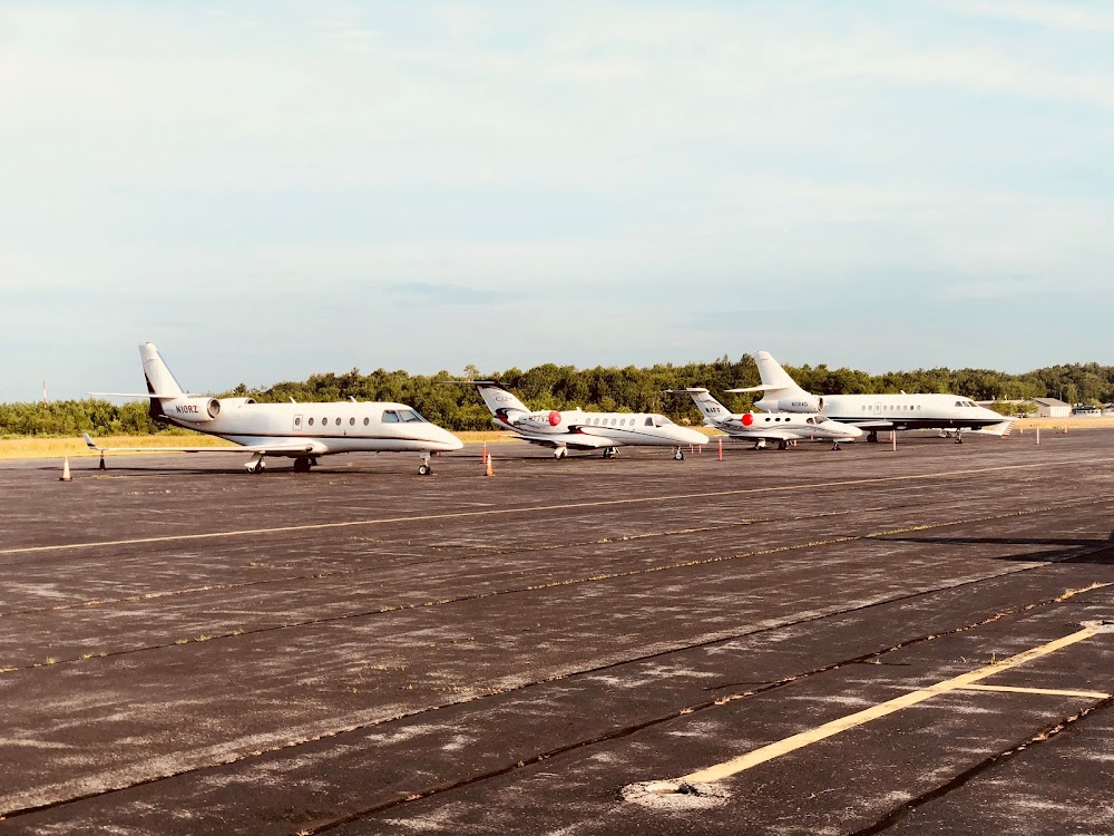
Rockland, ME
Elevation:
55ft
Sectional:
Montreal
Activation date:
Feb 1943
Fuel:
100LL, A (prices)
Runway 13/31:
5,412ft
Runway 03/21:
4,000ft
Access: Open to the public
Current Weather — VFR
-
Weather data is strictly informational and not for flight planning purposes.
-
METAR2026-07-21 06:56:00 EDT
Ceiling: Sky clear Wind: 210° @ 5kt Temperature: 62°F Dewpoint: 59°F Weather: N/A Visbility: 10SM Raw:METAR KRKD 211056Z AUTO 21005KT 10SM CLR 17/15 A2999 RMK AO2 SLP157 T01720150 -
TAF2026-07-21 08:00:00 EDT – 2026-07-21 10:00:00 EDT
Ceiling: 20,000ft Wind: 210° @ 8kt Weather: N/A Visbility: 6SM Clouds: Broken @ 20,000ft Raw:TAF KRKD 211120Z 2112/2212 21008KT P6SM BKN200 FM211400 17010G17KT P6SM BKN200 FM220000 13012G20KT P6SM OVC005 FM220200 15012G20KT 2SM BR OVC003 PROB30 2203/2206 3SM TSRA OVC008CB -
TAF2026-07-21 10:00:00 EDT – 2026-07-21 20:00:00 EDT
Ceiling: 20,000ft Wind: 170° @ 10kt, gusts 17kt Weather: N/A Visbility: 6SM Clouds: Broken @ 20,000ft Raw:TAF KRKD 211120Z 2112/2212 21008KT P6SM BKN200 FM211400 17010G17KT P6SM BKN200 FM220000 13012G20KT P6SM OVC005 FM220200 15012G20KT 2SM BR OVC003 PROB30 2203/2206 3SM TSRA OVC008CB -
TAF2026-07-21 20:00:00 EDT – 2026-07-21 22:00:00 EDT
Ceiling: 500ft Wind: 130° @ 12kt, gusts 20kt Weather: N/A Visbility: 6SM Clouds: Overcast @ 500ft Raw:TAF KRKD 211120Z 2112/2212 21008KT P6SM BKN200 FM211400 17010G17KT P6SM BKN200 FM220000 13012G20KT P6SM OVC005 FM220200 15012G20KT 2SM BR OVC003 PROB30 2203/2206 3SM TSRA OVC008CB -
TAF2026-07-21 22:00:00 EDT – 2026-07-22 08:00:00 EDT
Ceiling: 300ft Wind: 150° @ 12kt, gusts 20kt Weather: Mist Visbility: 2SM Clouds: Overcast @ 300ft Raw:TAF KRKD 211120Z 2112/2212 21008KT P6SM BKN200 FM211400 17010G17KT P6SM BKN200 FM220000 13012G20KT P6SM OVC005 FM220200 15012G20KT 2SM BR OVC003 PROB30 2203/2206 3SM TSRA OVC008CB -
TAF2026-07-21 23:00:00 EDT – 2026-07-22 02:00:00 EDT
Ceiling: 800ft Wind: 000° @ kt Weather: Thunderstorm rain Visbility: 3SM Clouds: Overcast @ 800ft Raw:TAF KRKD 211120Z 2112/2212 21008KT P6SM BKN200 FM211400 17010G17KT P6SM BKN200 FM220000 13012G20KT P6SM OVC005 FM220200 15012G20KT 2SM BR OVC003 PROB30 2203/2206 3SM TSRA OVC008CB
Click/tap to add an annotation marker to the map
Remarks
- Existed prior to 1959.
- Deer & seagulls on & invof arpt.
- Voluntary ngt cufrew in efct 2230-0600.
- Noise abatement procs in efct, call 207-596-0617 or visit website for specific instructions.
- For cd when apch clsd ctc boston artcc at 603-879-6859.
- Actvt malsr rwy 13; reil rwy 03 & 31; papi rwy 03, 13 & 31; hirl rwy 13/31; mirl rwy 03/21 - ctaf.
- Call fbo 207-594-2171 for avbl.
- Arpt may be unatndd fm 2200-0600.
Comments