Pirep is a free, collaborative database of all public and private airports. All pilots are welcome to contribute their local knowledge to any airport, no registration required.
Undocumented
METAR / TAF
Edit Tags
No upcoming events. Is anything happening here soon?
Airport Statistics
- Fuel pump location
- Airport map annotations
- Webcam links
Location:
Milton, FL
Elevation:
199ft
Sectional:
New Orleans
Fuel:
100LL (prices)
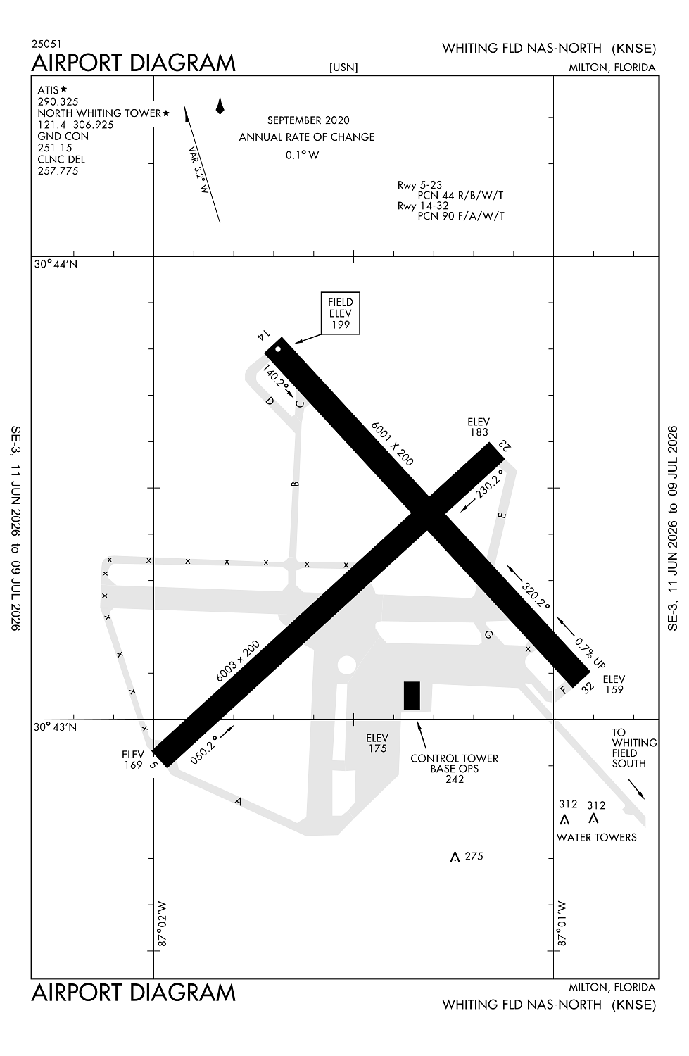
Runway 05/23:
6,003ft
Runway 14/32:
6,001ft
Access: Private to everyone
This is a military facility.
Current Weather — MVFR
-
Weather data is strictly informational and not for flight planning purposes.
-
METAR2026-07-21 08:56:00 CDT
Ceiling: 1,800ft Wind: 050° @ 14kt Temperature: 80°F Dewpoint: 75°F Weather: N/A Visbility: 10SM Clouds: Broken @ 1,800ft Raw:METAR KNSE 211356Z 05014KT 10SM BKN018 27/24 A2982 RMK AO2 SLP083 T02720239 $ -
TAF2026-07-21 06:00:00 CDT – 2026-07-21 10:00:00 CDT
Ceiling: 3,000ft Wind: 030° @ 10kt Weather: N/A Visbility: 6SM Clouds: Scattered @ 1,500ft, Broken @ 3,000ft, Broken @ 7,000ft Raw:TAF AMD KNSE 211100Z 2111/2207 03010KT 9999 SCT015 BKN030 BKN070 BKN250 QNH2979INS TEMPO 2111/2115 05012G20KT SCT007 BKN015 BECMG 2115/2117 07018G28KT 9999 VCSH SCT030 BKN060 BKN120 BKN250 QNH2974INS TEMPO 2118/2200 08020G32KT 6000 RA SCT020 BKN035 OVC100 FM220200 08012G18KT 9999 VCSH SCT020 BKN040 BKN090 BKN250 QNH2974INS TX30/2117Z TN24/2112Z AMD 1057 FN20071 -
TAF2026-07-21 06:00:00 CDT – 2026-07-21 10:00:00 CDT
Ceiling: 1,500ft Wind: 050° @ 12kt, gusts 20kt Weather: N/A Visbility: SM Clouds: Scattered @ 700ft, Broken @ 1,500ft Raw:TAF AMD KNSE 211100Z 2111/2207 03010KT 9999 SCT015 BKN030 BKN070 BKN250 QNH2979INS TEMPO 2111/2115 05012G20KT SCT007 BKN015 BECMG 2115/2117 07018G28KT 9999 VCSH SCT030 BKN060 BKN120 BKN250 QNH2974INS TEMPO 2118/2200 08020G32KT 6000 RA SCT020 BKN035 OVC100 FM220200 08012G18KT 9999 VCSH SCT020 BKN040 BKN090 BKN250 QNH2974INS TX30/2117Z TN24/2112Z AMD 1057 FN20071 -
TAF2026-07-21 10:00:00 CDT – 2026-07-21 21:00:00 CDT
Ceiling: 6,000ft Wind: 070° @ 18kt, gusts 28kt Weather: Showers in vicinity Visbility: 6SM Clouds: Scattered @ 3,000ft, Broken @ 6,000ft, Broken @ 12,000ft Raw:TAF AMD KNSE 211100Z 2111/2207 03010KT 9999 SCT015 BKN030 BKN070 BKN250 QNH2979INS TEMPO 2111/2115 05012G20KT SCT007 BKN015 BECMG 2115/2117 07018G28KT 9999 VCSH SCT030 BKN060 BKN120 BKN250 QNH2974INS TEMPO 2118/2200 08020G32KT 6000 RA SCT020 BKN035 OVC100 FM220200 08012G18KT 9999 VCSH SCT020 BKN040 BKN090 BKN250 QNH2974INS TX30/2117Z TN24/2112Z AMD 1057 FN20071 -
TAF2026-07-21 13:00:00 CDT – 2026-07-21 19:00:00 CDT
Ceiling: 3,500ft Wind: 080° @ 20kt, gusts 32kt Weather: Rain Visbility: 3SM Clouds: Scattered @ 2,000ft, Broken @ 3,500ft, Overcast @ 10,000ft Raw:TAF AMD KNSE 211100Z 2111/2207 03010KT 9999 SCT015 BKN030 BKN070 BKN250 QNH2979INS TEMPO 2111/2115 05012G20KT SCT007 BKN015 BECMG 2115/2117 07018G28KT 9999 VCSH SCT030 BKN060 BKN120 BKN250 QNH2974INS TEMPO 2118/2200 08020G32KT 6000 RA SCT020 BKN035 OVC100 FM220200 08012G18KT 9999 VCSH SCT020 BKN040 BKN090 BKN250 QNH2974INS TX30/2117Z TN24/2112Z AMD 1057 FN20071 -
TAF2026-07-21 21:00:00 CDT – 2026-07-22 02:00:00 CDT
Ceiling: 4,000ft Wind: 080° @ 12kt, gusts 18kt Weather: Showers in vicinity Visbility: 6SM Clouds: Scattered @ 2,000ft, Broken @ 4,000ft, Broken @ 9,000ft Raw:TAF AMD KNSE 211100Z 2111/2207 03010KT 9999 SCT015 BKN030 BKN070 BKN250 QNH2979INS TEMPO 2111/2115 05012G20KT SCT007 BKN015 BECMG 2115/2117 07018G28KT 9999 VCSH SCT030 BKN060 BKN120 BKN250 QNH2974INS TEMPO 2118/2200 08020G32KT 6000 RA SCT020 BKN035 OVC100 FM220200 08012G18KT 9999 VCSH SCT020 BKN040 BKN090 BKN250 QNH2974INS TX30/2117Z TN24/2112Z AMD 1057 FN20071
Click/tap to add an annotation marker to the map
No webcams added yet.
Remarks
- Rstd: ppr for tsnt prac apch & ldg; ltd tsnt prk & svc avbl. ctc duty ops for ppr info, ppr 24 hr pn c850-623-7475 or e-mail whtg_naswf_airops_afm@navy.mil. ctc airfield manager for calp, c850-665-6133 or 850-623-7329 or e-mail: leann.m.bair.civ@us.navy.mil
- Ctn: trng ops invof all hrs; ponding ocrs aft rain - brap.
- Service-jasu-1(nc-8) fuel - f24 tran alert. ltd tran line svc avbl 1400-220z++ mon-fri only.
- Twy z & 200 ft inward fm compass rose of twy a not vsb fm atct.
- Dd-1801 wx codes obtained at https:/fwb.metoc.navy.mil. metoc aft hr - aws/norfolk 1-888-745-6899.
Comments