Pirep is a free, collaborative database of all public and private airports. All pilots are welcome to contribute their local knowledge to any airport, no registration required.
Undocumented
METAR / TAF
Edit Tags
No upcoming events. Is anything happening here soon?
Airport Statistics
- General description
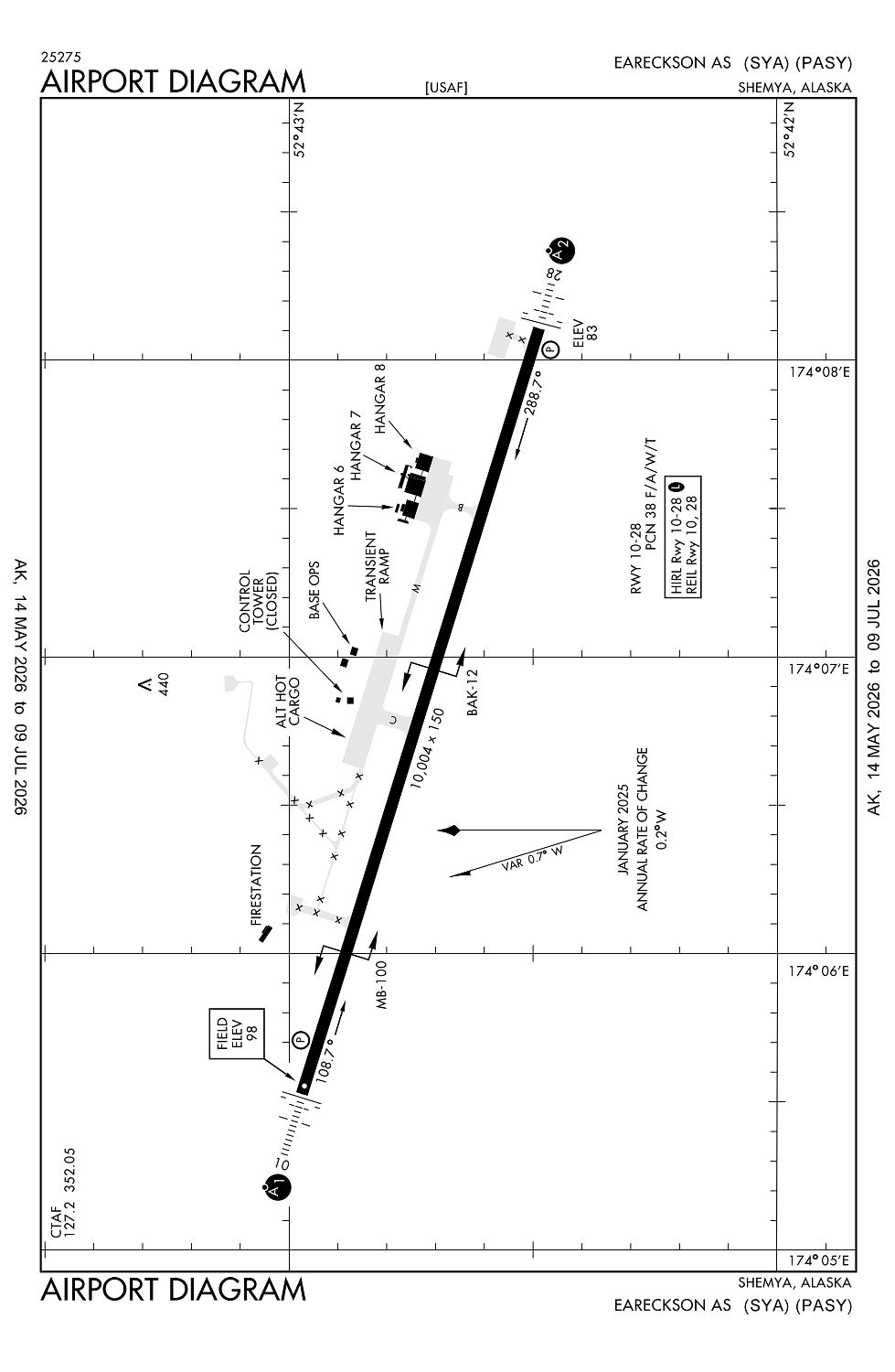
- Airport map annotations
- Crew car availability
Location:
Shemya, AK
Elevation:
97ft
Sectional:
W Aleutian Isls
Activation date:
May 1949
Fuel:
None
Runway 10/28:
10,004ft
Access: Private to everyone
This is a military facility.
Current Weather — LIFR
-
Weather data is strictly informational and not for flight planning purposes.
-
METAR2026-07-21 03:57:00 HDT
Ceiling: 200ft Wind: 230° @ 12kt, gusts 18kt Temperature: 48°F Dewpoint: 47°F Weather: Fog Visbility: 0SM Clouds: Obscured @ 200ft Raw:METAR PASY 211257Z 23012G18KT 1/2SM FG VV002 09/09 A2979 RMK AO2A VIS N-E 1/4V3/4 SLP087 ALSTG/SLP ESTMD WND DATA ESTMD T00900088 RVRNO PNO $ -
TAF2026-07-21 01:00:00 HDT – 2026-07-21 05:00:00 HDT
Ceiling: 700ft Wind: 000° @ kt Weather: N/A Visbility: 1SM Clouds: Overcast @ 700ft Raw:TAF AMD PASY 211000Z 2110/2212 23015G20KT 0800 FG OVC002 QNH2974INS TEMPO 2110/2114 3200 OVC007 BECMG 2114/2115 20020G30KT 8000 -RA OVC003 520004 QNH2952INS BECMG 2200/2201 23015G25KT 9999 NSW OVC003 QNH2951INS TX11/2118Z TN08/2110Z -
TAF2026-07-21 01:00:00 HDT – 2026-07-21 05:00:00 HDT
Ceiling: 200ft Wind: 230° @ 15kt, gusts 20kt Weather: Fog Visbility: 0SM Clouds: Overcast @ 200ft Raw:TAF AMD PASY 211000Z 2110/2212 23015G20KT 0800 FG OVC002 QNH2974INS TEMPO 2110/2114 3200 OVC007 BECMG 2114/2115 20020G30KT 8000 -RA OVC003 520004 QNH2952INS BECMG 2200/2201 23015G25KT 9999 NSW OVC003 QNH2951INS TX11/2118Z TN08/2110Z -
TAF2026-07-21 05:00:00 HDT – 2026-07-21 15:00:00 HDT
Ceiling: 300ft Wind: 200° @ 20kt, gusts 30kt Weather: Light rain Visbility: 4SM Clouds: Overcast @ 300ft Raw:TAF AMD PASY 211000Z 2110/2212 23015G20KT 0800 FG OVC002 QNH2974INS TEMPO 2110/2114 3200 OVC007 BECMG 2114/2115 20020G30KT 8000 -RA OVC003 520004 QNH2952INS BECMG 2200/2201 23015G25KT 9999 NSW OVC003 QNH2951INS TX11/2118Z TN08/2110Z -
TAF2026-07-21 15:00:00 HDT – 2026-07-22 03:00:00 HDT
Ceiling: 300ft Wind: 230° @ 15kt, gusts 25kt Weather: N/A Visbility: 6SM Clouds: Overcast @ 300ft Raw:TAF AMD PASY 211000Z 2110/2212 23015G20KT 0800 FG OVC002 QNH2974INS TEMPO 2110/2114 3200 OVC007 BECMG 2114/2115 20020G30KT 8000 -RA OVC003 520004 QNH2952INS BECMG 2200/2201 23015G25KT 9999 NSW OVC003 QNH2951INS TX11/2118Z TN08/2110Z
Click/tap to add an annotation marker to the map
No webcams added yet.
Remarks
- This airport has been surveyed by the national geodetic survey.
- 352.050 uhf.
- Customs unavbl.
- Arff index 7c
- Hills 8 nm w 662 ft msl.
Comments