Pirep is a free, collaborative database of all public and private airports. All pilots are welcome to contribute their local knowledge to any airport, no registration required.
Undocumented
METAR / TAF
Edit Tags
No upcoming events. Is anything happening here soon?
Airport Statistics
- Airport map annotations
- General description
- Local flying clubs
Location:
Glendale, AZ
Elevation:
1,083ft
Sectional:
Phoenix
Activation date:
Sep 1943
Fuel:
A++
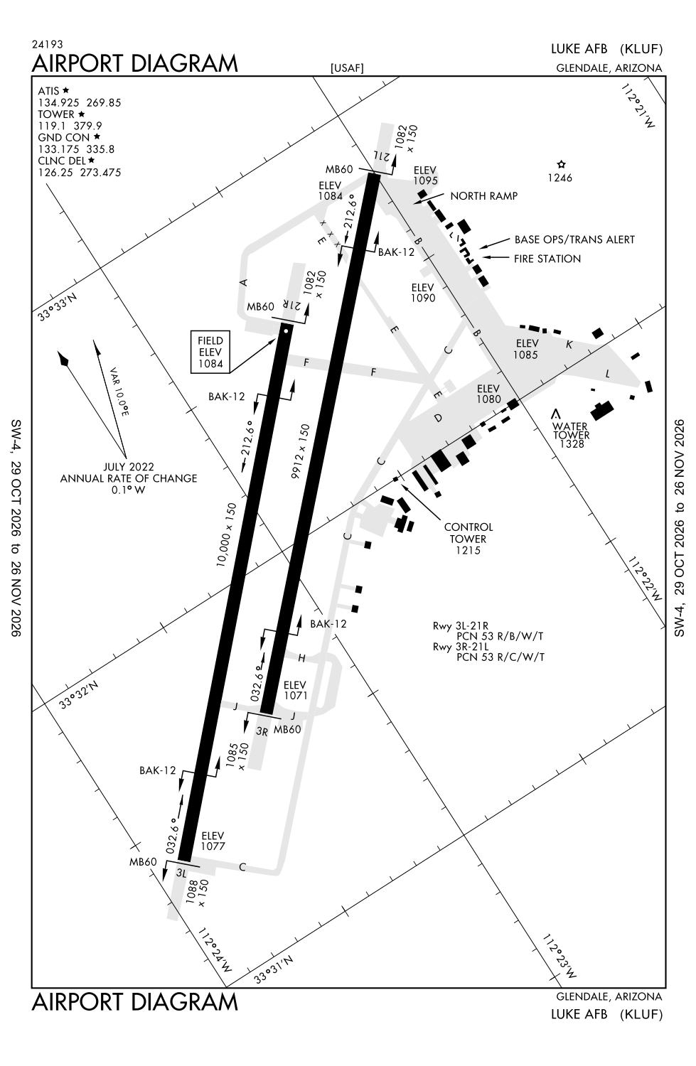
Runway 03L/21R:
10,000ft
Runway 03R/21L:
9,912ft
Access: Private to everyone
This is a military facility.
Current Weather — VFR
-
Weather data is strictly informational and not for flight planning purposes.
-
METAR2026-10-30 09:14:00 MST
Ceiling: 4,900ft Wind: 340° @ 9kt Temperature: 66°F Dewpoint: 62°F Weather: Light thunderstorm rain Visbility: 8SM Clouds: Overcast @ 4,900ft Raw:SPECI KLUF 301614Z 34009KT 8SM -TSRA OVC049 19/17 A2989 RMK AO2A RAB1555E1559DZB1559E04RAB14 TSB1555E02TSB12 SLP114 $ -
TAF2026-10-30 08:00:00 MST – 2026-10-30 11:00:00 MST
Ceiling: 7,000ft Wind: Variable Weather: Showers in vicinity Visbility: 6SM Clouds: Broken @ 7,000ft Raw:TAF AMD KLUF 301500Z 3015/3118 VRB06KT 9999 VCSH BKN070 QNH2984INS TEMPO 3015/3016 8000 -TSRA BKN050CB BECMG 3018/3019 05009KT 8000 -SHRA VCTS BKN040CB QNH2983INS TEMPO 3019/3023 21010G20KT 6000 -TSRA BKN030CB BECMG 3100/3101 VRB06KT 9999 NSW SCT030 BKN160 QNH2986INS BECMG 3108/3109 VRB06KT 9999 BKN060 QNH2990INS TX26/3022Z TN18/3113Z -
TAF2026-10-30 08:00:00 MST – 2026-10-30 09:00:00 MST
Ceiling: 5,000ft Wind: 000° @ kt Weather: Light thunderstorm rain Visbility: 4SM Clouds: Broken @ 5,000ft Raw:TAF AMD KLUF 301500Z 3015/3118 VRB06KT 9999 VCSH BKN070 QNH2984INS TEMPO 3015/3016 8000 -TSRA BKN050CB BECMG 3018/3019 05009KT 8000 -SHRA VCTS BKN040CB QNH2983INS TEMPO 3019/3023 21010G20KT 6000 -TSRA BKN030CB BECMG 3100/3101 VRB06KT 9999 NSW SCT030 BKN160 QNH2986INS BECMG 3108/3109 VRB06KT 9999 BKN060 QNH2990INS TX26/3022Z TN18/3113Z -
TAF2026-10-30 11:00:00 MST – 2026-10-30 17:00:00 MST
Ceiling: 4,000ft Wind: 050° @ 9kt Weather: Light rain showers, thunderstorm in vicinity Visbility: 4SM Clouds: Broken @ 4,000ft Raw:TAF AMD KLUF 301500Z 3015/3118 VRB06KT 9999 VCSH BKN070 QNH2984INS TEMPO 3015/3016 8000 -TSRA BKN050CB BECMG 3018/3019 05009KT 8000 -SHRA VCTS BKN040CB QNH2983INS TEMPO 3019/3023 21010G20KT 6000 -TSRA BKN030CB BECMG 3100/3101 VRB06KT 9999 NSW SCT030 BKN160 QNH2986INS BECMG 3108/3109 VRB06KT 9999 BKN060 QNH2990INS TX26/3022Z TN18/3113Z -
TAF2026-10-30 12:00:00 MST – 2026-10-30 16:00:00 MST
Ceiling: 3,000ft Wind: 210° @ 10kt, gusts 20kt Weather: Light thunderstorm rain Visbility: 3SM Clouds: Broken @ 3,000ft Raw:TAF AMD KLUF 301500Z 3015/3118 VRB06KT 9999 VCSH BKN070 QNH2984INS TEMPO 3015/3016 8000 -TSRA BKN050CB BECMG 3018/3019 05009KT 8000 -SHRA VCTS BKN040CB QNH2983INS TEMPO 3019/3023 21010G20KT 6000 -TSRA BKN030CB BECMG 3100/3101 VRB06KT 9999 NSW SCT030 BKN160 QNH2986INS BECMG 3108/3109 VRB06KT 9999 BKN060 QNH2990INS TX26/3022Z TN18/3113Z -
TAF2026-10-30 17:00:00 MST – 2026-10-31 01:00:00 MST
Ceiling: 16,000ft Wind: Variable Weather: N/A Visbility: 6SM Clouds: Scattered @ 3,000ft, Broken @ 16,000ft Raw:TAF AMD KLUF 301500Z 3015/3118 VRB06KT 9999 VCSH BKN070 QNH2984INS TEMPO 3015/3016 8000 -TSRA BKN050CB BECMG 3018/3019 05009KT 8000 -SHRA VCTS BKN040CB QNH2983INS TEMPO 3019/3023 21010G20KT 6000 -TSRA BKN030CB BECMG 3100/3101 VRB06KT 9999 NSW SCT030 BKN160 QNH2986INS BECMG 3108/3109 VRB06KT 9999 BKN060 QNH2990INS TX26/3022Z TN18/3113Z -
TAF2026-10-31 01:00:00 MST – 2026-10-31 11:00:00 MST
Ceiling: 6,000ft Wind: Variable Weather: N/A Visbility: 6SM Clouds: Broken @ 6,000ft Raw:TAF AMD KLUF 301500Z 3015/3118 VRB06KT 9999 VCSH BKN070 QNH2984INS TEMPO 3015/3016 8000 -TSRA BKN050CB BECMG 3018/3019 05009KT 8000 -SHRA VCTS BKN040CB QNH2983INS TEMPO 3019/3023 21010G20KT 6000 -TSRA BKN030CB BECMG 3100/3101 VRB06KT 9999 NSW SCT030 BKN160 QNH2986INS BECMG 3108/3109 VRB06KT 9999 BKN060 QNH2990INS TX26/3022Z TN18/3113Z
Click/tap to add an annotation marker to the map
No webcams added yet.
Remarks
- Dusk-0530z mon-thur, dusk-0130z fri.
- Rdcd level arff cpbltys cat 1-7; critical level arff cpbltys cat 8-10; wkend & hol further rdc cpbltys. svr risk loss; arff not expd to extinguish interior fire or successful rescue ops. ltd exterior arff performed - amgmt to verify.
- Rstd: hover ldg na wo atct perm.
- Rstd: ppr all acft - d896-7131/ c623-856-7131/7132; ppr arr block time +/- 30 min of sked ldg.
- Tsnt must coord apvl for lcl sorties prior to arr. tsnt classified storage na at amops; ctc command post for storage - d896-5600/c623-856-5600.
Comments