Pirep is a free, collaborative database of all public and private airports. All pilots are welcome to contribute their local knowledge to any airport, no registration required.
No upcoming events. Is anything happening here soon?
Last updated: 2024-02-29 21:37:55 PST
Airport Statistics
- Transient parking location
- Crew car availability
- Airport map annotations
Location:
Lemoore, CA
Elevation:
228ft
Sectional:
San Francisco
Fuel:
None
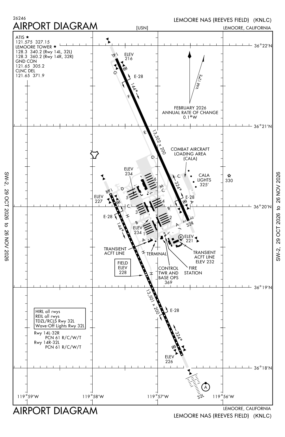
Runway 14L/32R:
13,502ft
Runway 14R/32L:
13,501ft
Access: Private to everyone
This is a military facility.
Similar Airports

Current Weather — VFR
-
Weather data is strictly informational and not for flight planning purposes.
-
METAR2026-11-19 15:56:00 PST
Ceiling: 7,000ft Wind: 250° @ 7kt Temperature: 55°F Dewpoint: 48°F Weather: N/A Visbility: 10SM Clouds: Scattered @ 4,000ft, Broken @ 7,000ft, Broken @ 16,000ft Raw:METAR KNLC 192356Z 25007KT 10SM SCT040 BKN070 BKN160 13/09 A2992 RMK AO2 RAE52 SLP131 CB DSNT SE RH/74 P0003 60005 T01330089 10183 20122 51036 $ -
TAF2026-11-19 15:00:00 PST – 2026-11-19 16:00:00 PST
Ceiling: 6,000ft Wind: 300° @ 15kt, gusts 24kt Weather: Rain Visbility: 6SM Clouds: Scattered @ 4,500ft, Broken @ 6,000ft, Broken @ 8,000ft Raw:TAF KNLC 192250Z 1923/2023 30015G24KT 9999 RA SCT045 BKN060 BKN080 QNH2983INS BECMG 2000/2002 23006KT 9999 VCSH SCT045 SCT060 BKN090 QNH2985INS FM200400 VRB06KT 9999 SCT050 SCT100 TX13/2023Z TN02/2014Z FS30067 -
TAF2026-11-19 16:00:00 PST – 2026-11-19 20:00:00 PST
Ceiling: 9,000ft Wind: 230° @ 6kt Weather: Showers in vicinity Visbility: 6SM Clouds: Scattered @ 4,500ft, Scattered @ 6,000ft, Broken @ 9,000ft Raw:TAF KNLC 192250Z 1923/2023 30015G24KT 9999 RA SCT045 BKN060 BKN080 QNH2983INS BECMG 2000/2002 23006KT 9999 VCSH SCT045 SCT060 BKN090 QNH2985INS FM200400 VRB06KT 9999 SCT050 SCT100 TX13/2023Z TN02/2014Z FS30067 -
TAF2026-11-19 20:00:00 PST – 2026-11-20 15:00:00 PST
Ceiling: Sky clear Wind: Variable Weather: N/A Visbility: 6SM Clouds: Scattered @ 5,000ft, Scattered @ 10,000ft Raw:TAF KNLC 192250Z 1923/2023 30015G24KT 9999 RA SCT045 BKN060 BKN080 QNH2983INS BECMG 2000/2002 23006KT 9999 VCSH SCT045 SCT060 BKN090 QNH2985INS FM200400 VRB06KT 9999 SCT050 SCT100 TX13/2023Z TN02/2014Z FS30067
Click/tap to add an annotation marker to the map
No webcams added yet.
Remarks
- Rot bcn not opr when arpt clsd.
- Jasu: 2(gtc-85) 2(nc-5) 2(nc-8) 1(ncpp-105).
- Fuel: j5.
- Fluid: sp presair oxrb (lox avbl 1600-2400z++ mon-fri only.)
- Tran alert: ltd tran svc/maint avbl dur arpt opr hr. hi-speed fuel lanes not avbl to tran acft.
Comments