Pirep is a free, collaborative database of all public and private airports. All pilots are welcome to contribute their local knowledge to any airport, no registration required.


Public
Undocumented
Events
METAR / TAF
Edit Tags
Airport Statistics
- Local flying clubs
- Fuel pump location
- Transient parking location
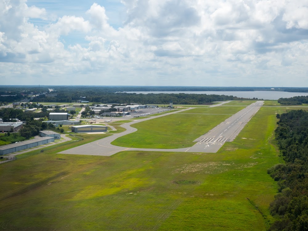
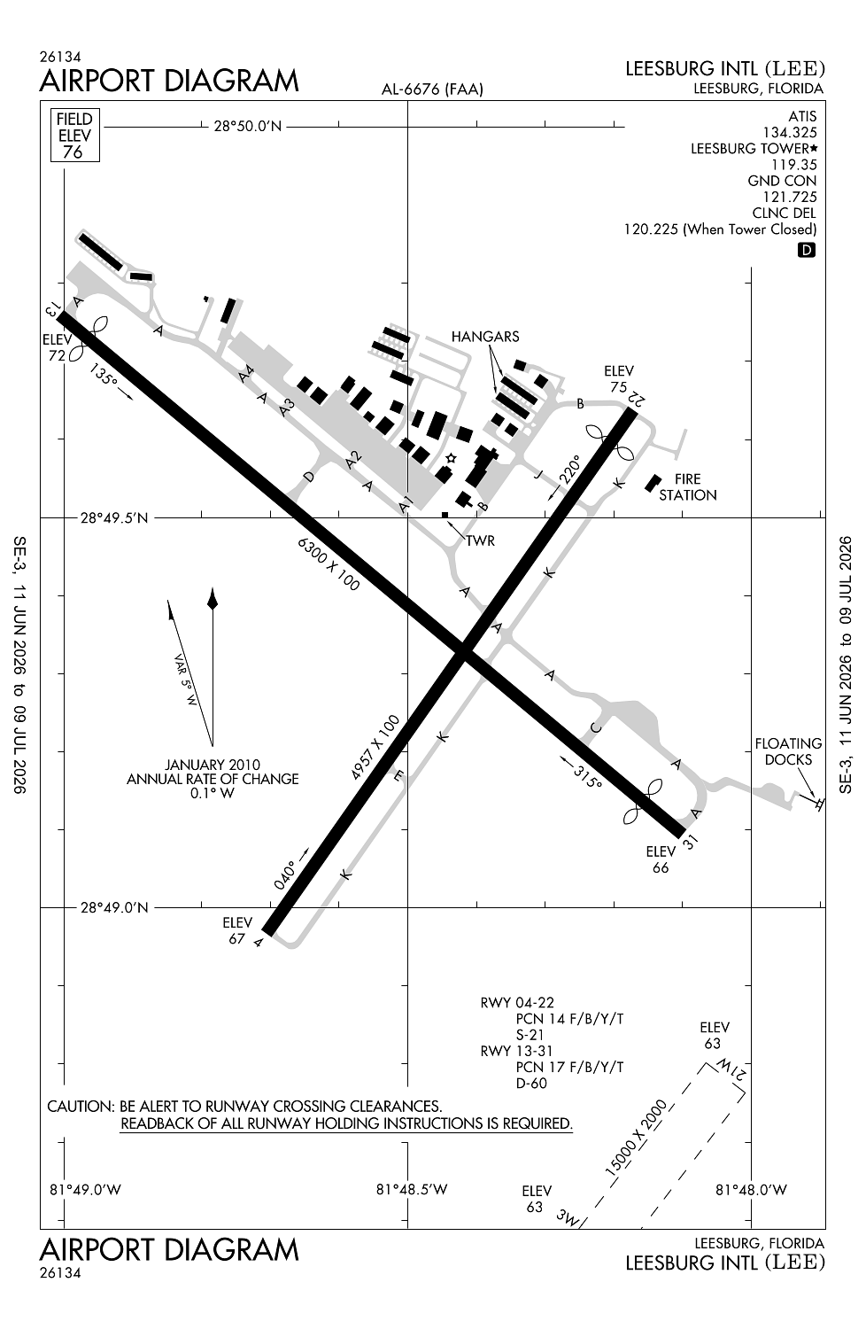
Location:
Leesburg, FL
Elevation:
76ft
Sectional:
Jacksonville
Activation date:
Jan 1943
Fuel:
100LL, A (prices)
Runway 03W/21W:
15,000ft
Runway 13/31:
6,300ft
Runway 04/22:
4,957ft
Access: Open to the public
Current Weather — MVFR
-
Weather data is strictly informational and not for flight planning purposes.
-
METAR2026-07-16 15:05:00 EDT
Ceiling: 5,500ft Wind: 280° @ 6kt Temperature: 78°F Dewpoint: 75°F Weather: Light rain, mist Visbility: 3SM Clouds: Scattered @ 4,000ft, Broken @ 5,500ft, Overcast @ 7,000ft Raw:SPECI KLEE 161905Z 28006KT 3SM -RA BR SCT040 BKN055 OVC070 26/24 A3008 RMK AO2 LTG DSNT S PRESFR P0002 T02610244 -
TAF2026-07-16 14:00:00 EDT – 2026-07-16 17:00:00 EDT
Ceiling: 3,000ft Wind: Variable, gusts 25kt Weather: Thunderstorm rain Visbility: 3SM Clouds: Broken @ 3,000ft Raw:TAF KLEE 161758Z 1618/1718 22009KT P6SM VCTS SCT035CB SCT060 SCT100 TEMPO 1618/1621 VRB15G25KT 3SM TSRA BKN030CB FM162300 28006KT P6SM SCT060 SCT100 BKN250 FM171400 34005KT P6SM FEW040 SCT080 BKN250 -
TAF2026-07-16 14:00:00 EDT – 2026-07-16 19:00:00 EDT
Ceiling: Sky clear Wind: 220° @ 9kt Weather: Thunderstorm in vicinity Visbility: 6SM Clouds: Scattered @ 3,500ft, Scattered @ 6,000ft, Scattered @ 10,000ft Raw:TAF KLEE 161758Z 1618/1718 22009KT P6SM VCTS SCT035CB SCT060 SCT100 TEMPO 1618/1621 VRB15G25KT 3SM TSRA BKN030CB FM162300 28006KT P6SM SCT060 SCT100 BKN250 FM171400 34005KT P6SM FEW040 SCT080 BKN250 -
TAF2026-07-16 19:00:00 EDT – 2026-07-17 10:00:00 EDT
Ceiling: 25,000ft Wind: 280° @ 6kt Weather: N/A Visbility: 6SM Clouds: Scattered @ 6,000ft, Scattered @ 10,000ft, Broken @ 25,000ft Raw:TAF KLEE 161758Z 1618/1718 22009KT P6SM VCTS SCT035CB SCT060 SCT100 TEMPO 1618/1621 VRB15G25KT 3SM TSRA BKN030CB FM162300 28006KT P6SM SCT060 SCT100 BKN250 FM171400 34005KT P6SM FEW040 SCT080 BKN250 -
TAF2026-07-17 10:00:00 EDT – 2026-07-17 14:00:00 EDT
Ceiling: 25,000ft Wind: 340° @ 5kt Weather: N/A Visbility: 6SM Clouds: Few @ 4,000ft, Scattered @ 8,000ft, Broken @ 25,000ft Raw:TAF KLEE 161758Z 1618/1718 22009KT P6SM VCTS SCT035CB SCT060 SCT100 TEMPO 1618/1621 VRB15G25KT 3SM TSRA BKN030CB FM162300 28006KT P6SM SCT060 SCT100 BKN250 FM171400 34005KT P6SM FEW040 SCT080 BKN250
Click/tap to add an annotation marker to the map
No webcams added yet.
Remarks
- Existed prior to 1959.
- Bird act invof arpt.
- Unlgtd 30 ft obstns 440 ft bfr aer rwy 04.
- Actvt reils 13 & 31; papi rwys 04, 22, 13 & 31; mirl rwys 04/22 & 13/31 - ctaf. twy lgts opr dusk - 2200; aft 2200 actvt - ctaf.
- Ext 1130 or 352-728-9786.
Comments