Pirep is a free, collaborative database of all public and private airports. All pilots are welcome to contribute their local knowledge to any airport, no registration required.
Public
Undocumented
METAR / TAF
Edit Tags
No upcoming events. Is anything happening here soon?
Airport Statistics
- Airport photos
- Fuel pump location
- Transient parking location
Location:
Alliance, NE
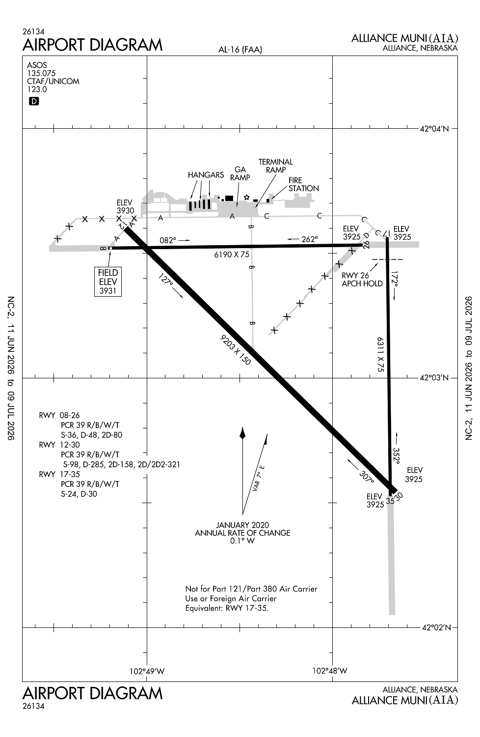
Elevation:
3,930ft
Sectional:
Cheyenne
Activation date:
Feb 1944
Fuel:
100LL, A (prices)
Runway 12/30:
9,203ft
Runway 17/35:
6,311ft
Runway 08/26:
6,190ft
Access: Open to the public
Current Weather — VFR
-
Weather data is strictly informational and not for flight planning purposes.
-
METAR2026-07-20 01:53:00 MDT
Ceiling: Sky clear Wind: 180° @ 7kt Temperature: 71°F Dewpoint: 57°F Weather: N/A Visbility: 10SM Raw:METAR KAIA 200753Z AUTO 18007KT 10SM CLR 22/14 A2999 RMK AO2 SLP097 T02170139 -
TAF2026-07-20 00:00:00 MDT – 2026-07-20 03:00:00 MDT
Ceiling: Sky clear Wind: 160° @ 11kt Weather: N/A Visbility: 6SM Clouds: Few @ 10,000ft Raw:TAF KAIA 200520Z 2006/2106 16011KT P6SM FEW100 FM200900 VRB06KT P6SM SKC FM201600 01009KT P6SM SCT130 PROB30 2020/2101 VRB30G45KT 3SM -TSRA BKN090CB FM210200 07020G27KT P6SM SCT130 BKN170 -
TAF2026-07-20 03:00:00 MDT – 2026-07-20 10:00:00 MDT
Ceiling: Sky clear Wind: Variable Weather: N/A Visbility: 6SM Clouds: @ ft Raw:TAF KAIA 200520Z 2006/2106 16011KT P6SM FEW100 FM200900 VRB06KT P6SM SKC FM201600 01009KT P6SM SCT130 PROB30 2020/2101 VRB30G45KT 3SM -TSRA BKN090CB FM210200 07020G27KT P6SM SCT130 BKN170 -
TAF2026-07-20 10:00:00 MDT – 2026-07-20 20:00:00 MDT
Ceiling: Sky clear Wind: 010° @ 9kt Weather: N/A Visbility: 6SM Clouds: Scattered @ 13,000ft Raw:TAF KAIA 200520Z 2006/2106 16011KT P6SM FEW100 FM200900 VRB06KT P6SM SKC FM201600 01009KT P6SM SCT130 PROB30 2020/2101 VRB30G45KT 3SM -TSRA BKN090CB FM210200 07020G27KT P6SM SCT130 BKN170 -
TAF2026-07-20 14:00:00 MDT – 2026-07-20 19:00:00 MDT
Ceiling: 9,000ft Wind: Variable, gusts 45kt Weather: Light thunderstorm rain Visbility: 3SM Clouds: Broken @ 9,000ft Raw:TAF KAIA 200520Z 2006/2106 16011KT P6SM FEW100 FM200900 VRB06KT P6SM SKC FM201600 01009KT P6SM SCT130 PROB30 2020/2101 VRB30G45KT 3SM -TSRA BKN090CB FM210200 07020G27KT P6SM SCT130 BKN170 -
TAF2026-07-20 20:00:00 MDT – 2026-07-21 00:00:00 MDT
Ceiling: 17,000ft Wind: 070° @ 20kt, gusts 27kt Weather: N/A Visbility: 6SM Clouds: Scattered @ 13,000ft, Broken @ 17,000ft Raw:TAF KAIA 200520Z 2006/2106 16011KT P6SM FEW100 FM200900 VRB06KT P6SM SKC FM201600 01009KT P6SM SCT130 PROB30 2020/2101 VRB30G45KT 3SM -TSRA BKN090CB FM210200 07020G27KT P6SM SCT130 BKN170
Click/tap to add an annotation marker to the map
No webcams added yet.
Remarks
- Rwy 17/35 not avbl for sked acr opns with more than 9 psgr seats or unsked acr at least 31 psgr seats.
- Ry 17/35 unavbl for use by air carriers.
- Ultralight & glider opns on & invof arpt.
- Aerial spraying opns on & invof arpt.
- Ry 08/26 designated calm wind.
Comments