Pirep is a free, collaborative database of all public and private airports. All pilots are welcome to contribute their local knowledge to any airport, no registration required.


Public
Undocumented
METAR / TAF
Edit Tags
No upcoming events. Is anything happening here soon?
Airport Statistics
- General description
- Airport photos
- Crew car availability
Location:
Nashville, TN
Elevation:
599ft
Sectional:
Atlanta
Activation date:
Dec 1937
Fuel:
100LL, A (prices)
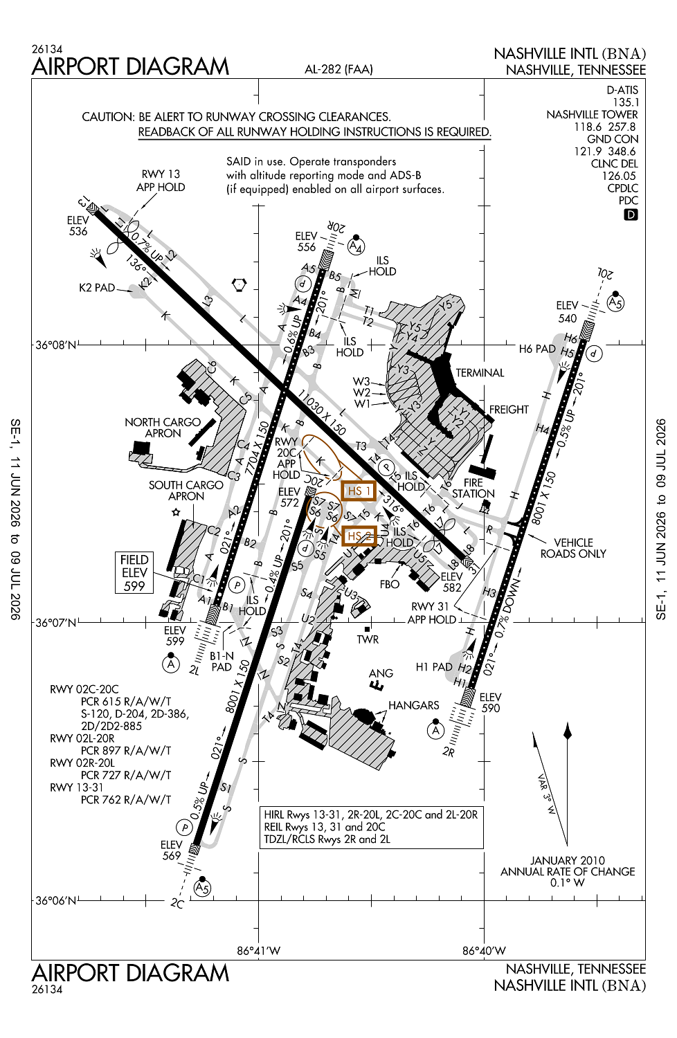
Runway 13/31:
11,030ft
Runway 02C/20C:
8,001ft
Runway 02R/20L:
8,001ft
Runway 02L/20R:
7,704ft
Access: Open to the public
Current Weather — VFR
-
Weather data is strictly informational and not for flight planning purposes.
-
METAR2026-07-20 02:53:00 CDT
Ceiling: Sky clear Wind: 140° @ 3kt Temperature: 73°F Dewpoint: 69°F Weather: N/A Visbility: 10SM Raw:METAR KBNA 200753Z 14003KT 10SM CLR 23/21 A2992 RMK AO2 SLP124 T02280211 $ -
TAF2026-07-20 01:00:00 CDT – 2026-07-20 05:00:00 CDT
Ceiling: Sky clear Wind: Calm Weather: N/A Visbility: 6SM Clouds: Scattered @ 15,000ft Raw:TAF KBNA 200520Z 2006/2112 00000KT P6SM SCT150 FM201000 00000KT P6SM BKN025 BKN150 TEMPO 2010/2014 BKN009 FM201700 22005KT P6SM SCT040 BKN090 PROB30 2018/2023 5SM -TSRA BKN035CB FM210200 19003KT P6SM BKN150 -
TAF2026-07-20 05:00:00 CDT – 2026-07-20 09:00:00 CDT
Ceiling: 900ft Wind: 000° @ kt Weather: N/A Visbility: SM Clouds: Broken @ 900ft Raw:TAF KBNA 200520Z 2006/2112 00000KT P6SM SCT150 FM201000 00000KT P6SM BKN025 BKN150 TEMPO 2010/2014 BKN009 FM201700 22005KT P6SM SCT040 BKN090 PROB30 2018/2023 5SM -TSRA BKN035CB FM210200 19003KT P6SM BKN150 -
TAF2026-07-20 05:00:00 CDT – 2026-07-20 12:00:00 CDT
Ceiling: 2,500ft Wind: Calm Weather: N/A Visbility: 6SM Clouds: Broken @ 2,500ft, Broken @ 15,000ft Raw:TAF KBNA 200520Z 2006/2112 00000KT P6SM SCT150 FM201000 00000KT P6SM BKN025 BKN150 TEMPO 2010/2014 BKN009 FM201700 22005KT P6SM SCT040 BKN090 PROB30 2018/2023 5SM -TSRA BKN035CB FM210200 19003KT P6SM BKN150 -
TAF2026-07-20 12:00:00 CDT – 2026-07-20 21:00:00 CDT
Ceiling: 9,000ft Wind: 220° @ 5kt Weather: N/A Visbility: 6SM Clouds: Scattered @ 4,000ft, Broken @ 9,000ft Raw:TAF KBNA 200520Z 2006/2112 00000KT P6SM SCT150 FM201000 00000KT P6SM BKN025 BKN150 TEMPO 2010/2014 BKN009 FM201700 22005KT P6SM SCT040 BKN090 PROB30 2018/2023 5SM -TSRA BKN035CB FM210200 19003KT P6SM BKN150 -
TAF2026-07-20 13:00:00 CDT – 2026-07-20 18:00:00 CDT
Ceiling: 3,500ft Wind: 000° @ kt Weather: Light thunderstorm rain Visbility: 5SM Clouds: Broken @ 3,500ft Raw:TAF KBNA 200520Z 2006/2112 00000KT P6SM SCT150 FM201000 00000KT P6SM BKN025 BKN150 TEMPO 2010/2014 BKN009 FM201700 22005KT P6SM SCT040 BKN090 PROB30 2018/2023 5SM -TSRA BKN035CB FM210200 19003KT P6SM BKN150 -
TAF2026-07-20 21:00:00 CDT – 2026-07-21 07:00:00 CDT
Ceiling: 15,000ft Wind: 190° @ 3kt Weather: N/A Visbility: 6SM Clouds: Broken @ 15,000ft Raw:TAF KBNA 200520Z 2006/2112 00000KT P6SM SCT150 FM201000 00000KT P6SM BKN025 BKN150 TEMPO 2010/2014 BKN009 FM201700 22005KT P6SM SCT040 BKN090 PROB30 2018/2023 5SM -TSRA BKN035CB FM210200 19003KT P6SM BKN150
Click/tap to add an annotation marker to the map
No webcams added yet.
Remarks
- Ctn: read back & compliance of rwy hldg instrn rqr; spcly twy k & rwy 20c, twy l at rwy 13 & twy h at rwy 31.
- Flt notification svc (adcus) avbl.
- Tbjt rwy noise abatement proc; mil tbjt use rwy 13/31 for arr & dep.
- 180 deg turns ovr 12500 lbs na on asph sfc.
- Flt ovr main trml na.
Comments