Pirep is a free, collaborative database of all public and private airports. All pilots are welcome to contribute their local knowledge to any airport, no registration required.
Undocumented
METAR / TAF
Edit Tags
No upcoming events. Is anything happening here soon?
Airport Statistics
- Transient parking location
- WiFi availability
- Airport map annotations
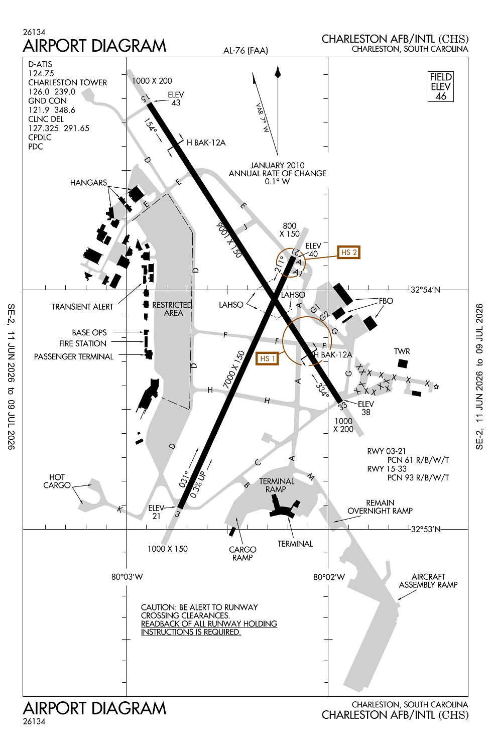
Location:
Charleston, SC
Elevation:
46ft
Sectional:
Charlotte
Activation date:
Oct 1937
Fuel:
100, A1+ (prices)
Runway 15/33:
9,001ft
Runway 03/21:
7,000ft
Access: Open to the public
Current Weather — VFR
-
Weather data is strictly informational and not for flight planning purposes.
-
METAR2026-07-20 08:56:00 EDT
Ceiling: Sky clear Wind: 210° @ 8kt Temperature: 86°F Dewpoint: 78°F Weather: N/A Visbility: 10SM Clouds: Few @ 2,500ft, Scattered @ 15,000ft, Scattered @ 25,000ft Raw:METAR KCHS 201256Z 21008KT 10SM FEW025 SCT150 SCT250 30/26 A2997 RMK AO2 SLP149 T03000256 -
TAF2026-07-20 08:00:00 EDT – 2026-07-20 09:00:00 EDT
Ceiling: Sky clear Wind: 190° @ 3kt Weather: N/A Visbility: 6SM Clouds: Few @ 2,000ft, Few @ 25,000ft Raw:TAF KCHS 201128Z 2012/2112 19003KT P6SM FEW020 FEW250 FM201300 22007KT P6SM SCT035 FM201900 19012G21KT P6SM FEW060 FM210000 20010KT P6SM BKN250 -
TAF2026-07-20 09:00:00 EDT – 2026-07-20 15:00:00 EDT
Ceiling: Sky clear Wind: 220° @ 7kt Weather: N/A Visbility: 6SM Clouds: Scattered @ 3,500ft Raw:TAF KCHS 201128Z 2012/2112 19003KT P6SM FEW020 FEW250 FM201300 22007KT P6SM SCT035 FM201900 19012G21KT P6SM FEW060 FM210000 20010KT P6SM BKN250 -
TAF2026-07-20 15:00:00 EDT – 2026-07-20 20:00:00 EDT
Ceiling: Sky clear Wind: 190° @ 12kt, gusts 21kt Weather: N/A Visbility: 6SM Clouds: Few @ 6,000ft Raw:TAF KCHS 201128Z 2012/2112 19003KT P6SM FEW020 FEW250 FM201300 22007KT P6SM SCT035 FM201900 19012G21KT P6SM FEW060 FM210000 20010KT P6SM BKN250 -
TAF2026-07-20 20:00:00 EDT – 2026-07-21 08:00:00 EDT
Ceiling: 25,000ft Wind: 200° @ 10kt Weather: N/A Visbility: 6SM Clouds: Broken @ 25,000ft Raw:TAF KCHS 201128Z 2012/2112 19003KT P6SM FEW020 FEW250 FM201300 22007KT P6SM SCT035 FM201900 19012G21KT P6SM FEW060 FM210000 20010KT P6SM BKN250
Click/tap to add an annotation marker to the map
No webcams added yet.
Remarks
- This airport has been surveyed by the national geodetic survey.
- Liquid oxygen serving avbl to military.
- No student solo touch and go landing allowed.
- Ppr for parking of general aviation acft on terminal ramp ctc 843-767-1100.
- Intensive heavy mil jets & other misc acft executing numerous cargo & personnel drops, high speed low-level formation flts & misc air-to-ground opns.
Comments