Pirep is a free, collaborative database of all public and private airports. All pilots are welcome to contribute their local knowledge to any airport, no registration required.

No upcoming events. Is anything happening here soon?
Last updated: 2024-02-03 14:18:59 EST
Airport Statistics
- Webcam links
- Airport map annotations
- Crew car availability
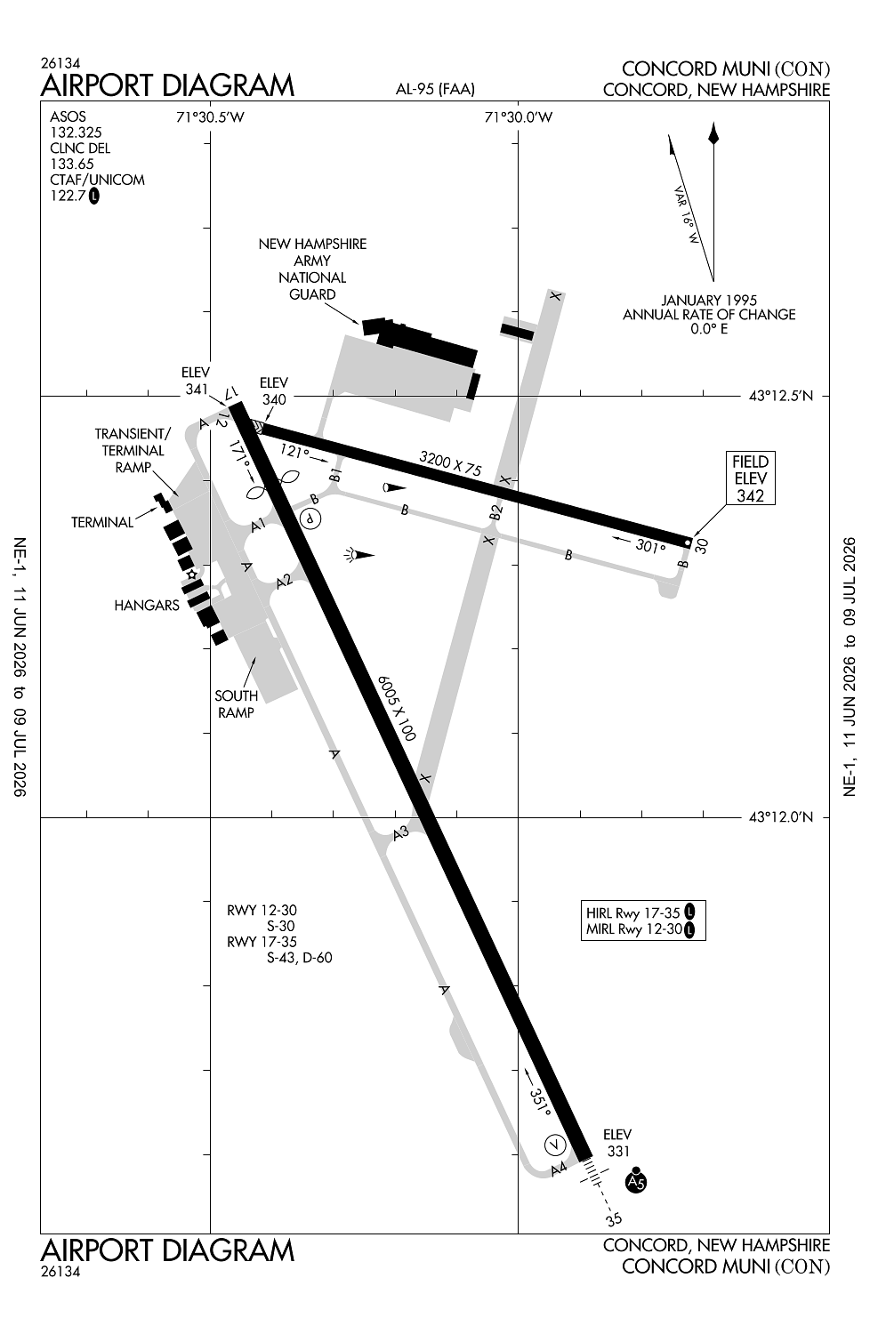
Location:
Concord, NH
Elevation:
341ft
Sectional:
New York
Activation date:
Mar 1947
Fuel:
100LL, A (prices)
Runway 17/35:
6,005ft
Runway 12/30:
3,200ft
Access: Open to the public
Similar Airports

Current Weather — VFR
-
Weather data is strictly informational and not for flight planning purposes.
-
METAR2026-07-29 02:51:00 EDT
Ceiling: 6,500ft Wind: Calm Temperature: 66°F Dewpoint: 64°F Weather: N/A Visbility: 10SM Clouds: Broken @ 6,500ft Raw:METAR KCON 290651Z AUTO 00000KT 10SM BKN065 19/18 A2970 RMK AO2 SLP055 T01940183 $ -
TAF2026-07-29 02:00:00 EDT – 2026-07-29 05:00:00 EDT
Ceiling: Sky clear Wind: Calm Weather: N/A Visbility: 6SM Clouds: @ ft Raw:TAF KCON 290527Z 2906/3006 00000KT P6SM SKC FM290900 12003KT P6SM OVC015 FM291200 VRB03KT 3SM BR OVC015 FM291800 10009KT 6SM -SHRA BR OVC015 FM300000 05010G20KT 2SM -SHRA BR OVC007 -
TAF2026-07-29 05:00:00 EDT – 2026-07-29 08:00:00 EDT
Ceiling: 1,500ft Wind: 120° @ 3kt Weather: N/A Visbility: 6SM Clouds: Overcast @ 1,500ft Raw:TAF KCON 290527Z 2906/3006 00000KT P6SM SKC FM290900 12003KT P6SM OVC015 FM291200 VRB03KT 3SM BR OVC015 FM291800 10009KT 6SM -SHRA BR OVC015 FM300000 05010G20KT 2SM -SHRA BR OVC007 -
TAF2026-07-29 08:00:00 EDT – 2026-07-29 14:00:00 EDT
Ceiling: 1,500ft Wind: Variable Weather: Mist Visbility: 3SM Clouds: Overcast @ 1,500ft Raw:TAF KCON 290527Z 2906/3006 00000KT P6SM SKC FM290900 12003KT P6SM OVC015 FM291200 VRB03KT 3SM BR OVC015 FM291800 10009KT 6SM -SHRA BR OVC015 FM300000 05010G20KT 2SM -SHRA BR OVC007 -
TAF2026-07-29 14:00:00 EDT – 2026-07-29 20:00:00 EDT
Ceiling: 1,500ft Wind: 100° @ 9kt Weather: Light rain showers, mist Visbility: 6SM Clouds: Overcast @ 1,500ft Raw:TAF KCON 290527Z 2906/3006 00000KT P6SM SKC FM290900 12003KT P6SM OVC015 FM291200 VRB03KT 3SM BR OVC015 FM291800 10009KT 6SM -SHRA BR OVC015 FM300000 05010G20KT 2SM -SHRA BR OVC007 -
TAF2026-07-29 20:00:00 EDT – 2026-07-30 02:00:00 EDT
Ceiling: 700ft Wind: 050° @ 10kt, gusts 20kt Weather: Light rain showers, mist Visbility: 2SM Clouds: Overcast @ 700ft Raw:TAF KCON 290527Z 2906/3006 00000KT P6SM SKC FM290900 12003KT P6SM OVC015 FM291200 VRB03KT 3SM BR OVC015 FM291800 10009KT 6SM -SHRA BR OVC015 FM300000 05010G20KT 2SM -SHRA BR OVC007
Click/tap to add an annotation marker to the map
No webcams added yet.
Remarks
- This airport has been surveyed by the national geodetic survey.
- Existed prior to 1959.
- Wildlife on & invof arpt.
- Ops on ng twy & ramp prohibited wo prior cdn due to scty.
- Day & ngt vfr hel ops to & fm new hampshire state police hngr.
Comments