Pirep is a free, collaborative database of all public and private airports. All pilots are welcome to contribute their local knowledge to any airport, no registration required.


Public
Undocumented
METAR / TAF
Edit Tags
No upcoming events. Is anything happening here soon?
Airport Statistics
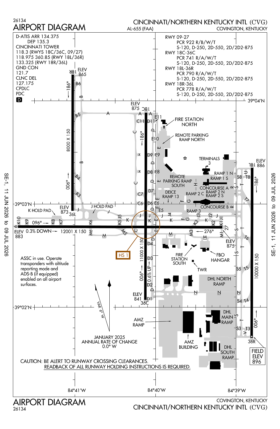
- WiFi availability
- Airport map annotations
- Fuel pump location
Location:
Covington, KY
Elevation:
896ft
Sectional:
Cincinnati
Activation date:
Dec 1944
Fuel:
100LL, A (prices)
Runway 09/27:
12,001ft
Runway 18C/36C:
11,000ft
Runway 18L/36R:
10,000ft
Runway 18R/36L:
8,000ft
Access: Open to the public
Current Weather — VFR
-
Weather data is strictly informational and not for flight planning purposes.
-
METAR2026-07-21 04:52:00 EDT
Ceiling: 25,000ft Wind: 200° @ 6kt Temperature: 73°F Dewpoint: 71°F Weather: N/A Visbility: 10SM Clouds: Broken @ 25,000ft Raw:METAR KCVG 210852Z 20006KT 10SM BKN250 23/22 A2980 RMK AO2 SLP079 T02280217 56015 $ -
TAF2026-07-21 05:00:00 EDT – 2026-07-21 09:00:00 EDT
Ceiling: 15,000ft Wind: 220° @ 6kt Weather: N/A Visbility: 6SM Clouds: Broken @ 15,000ft Raw:TAF KCVG 210914Z 2109/2212 22006KT P6SM BKN150 FM211300 24012KT P6SM -SHRA BKN050 PROB30 2113/2115 5SM -TSRA OVC025CB FM211800 25012G20KT P6SM -SHRA OVC035 PROB30 2118/2124 4SM TSRA OVC025CB FM220000 28012G22KT P6SM SCT040 BKN120 FM220400 32008KT P6SM SCT150 -
TAF2026-07-21 09:00:00 EDT – 2026-07-21 14:00:00 EDT
Ceiling: 5,000ft Wind: 240° @ 12kt Weather: Light rain showers Visbility: 6SM Clouds: Broken @ 5,000ft Raw:TAF KCVG 210914Z 2109/2212 22006KT P6SM BKN150 FM211300 24012KT P6SM -SHRA BKN050 PROB30 2113/2115 5SM -TSRA OVC025CB FM211800 25012G20KT P6SM -SHRA OVC035 PROB30 2118/2124 4SM TSRA OVC025CB FM220000 28012G22KT P6SM SCT040 BKN120 FM220400 32008KT P6SM SCT150 -
TAF2026-07-21 09:00:00 EDT – 2026-07-21 11:00:00 EDT
Ceiling: 2,500ft Wind: 000° @ kt Weather: Light thunderstorm rain Visbility: 5SM Clouds: Overcast @ 2,500ft Raw:TAF KCVG 210914Z 2109/2212 22006KT P6SM BKN150 FM211300 24012KT P6SM -SHRA BKN050 PROB30 2113/2115 5SM -TSRA OVC025CB FM211800 25012G20KT P6SM -SHRA OVC035 PROB30 2118/2124 4SM TSRA OVC025CB FM220000 28012G22KT P6SM SCT040 BKN120 FM220400 32008KT P6SM SCT150 -
TAF2026-07-21 14:00:00 EDT – 2026-07-21 20:00:00 EDT
Ceiling: 2,500ft Wind: 000° @ kt Weather: Thunderstorm rain Visbility: 4SM Clouds: Overcast @ 2,500ft Raw:TAF KCVG 210914Z 2109/2212 22006KT P6SM BKN150 FM211300 24012KT P6SM -SHRA BKN050 PROB30 2113/2115 5SM -TSRA OVC025CB FM211800 25012G20KT P6SM -SHRA OVC035 PROB30 2118/2124 4SM TSRA OVC025CB FM220000 28012G22KT P6SM SCT040 BKN120 FM220400 32008KT P6SM SCT150 -
TAF2026-07-21 14:00:00 EDT – 2026-07-21 20:00:00 EDT
Ceiling: 3,500ft Wind: 250° @ 12kt, gusts 20kt Weather: Light rain showers Visbility: 6SM Clouds: Overcast @ 3,500ft Raw:TAF KCVG 210914Z 2109/2212 22006KT P6SM BKN150 FM211300 24012KT P6SM -SHRA BKN050 PROB30 2113/2115 5SM -TSRA OVC025CB FM211800 25012G20KT P6SM -SHRA OVC035 PROB30 2118/2124 4SM TSRA OVC025CB FM220000 28012G22KT P6SM SCT040 BKN120 FM220400 32008KT P6SM SCT150 -
TAF2026-07-21 20:00:00 EDT – 2026-07-22 00:00:00 EDT
Ceiling: 12,000ft Wind: 280° @ 12kt, gusts 22kt Weather: N/A Visbility: 6SM Clouds: Scattered @ 4,000ft, Broken @ 12,000ft Raw:TAF KCVG 210914Z 2109/2212 22006KT P6SM BKN150 FM211300 24012KT P6SM -SHRA BKN050 PROB30 2113/2115 5SM -TSRA OVC025CB FM211800 25012G20KT P6SM -SHRA OVC035 PROB30 2118/2124 4SM TSRA OVC025CB FM220000 28012G22KT P6SM SCT040 BKN120 FM220400 32008KT P6SM SCT150 -
TAF2026-07-22 00:00:00 EDT – 2026-07-22 08:00:00 EDT
Ceiling: Sky clear Wind: 320° @ 8kt Weather: N/A Visbility: 6SM Clouds: Scattered @ 15,000ft Raw:TAF KCVG 210914Z 2109/2212 22006KT P6SM BKN150 FM211300 24012KT P6SM -SHRA BKN050 PROB30 2113/2115 5SM -TSRA OVC025CB FM211800 25012G20KT P6SM -SHRA OVC035 PROB30 2118/2124 4SM TSRA OVC025CB FM220000 28012G22KT P6SM SCT040 BKN120 FM220400 32008KT P6SM SCT150
Click/tap to add an annotation marker to the map
No webcams added yet.
Remarks
- Existed prior to 1959.
- Noise sens area n & s of arpt; rwy asgn 2200-0700 based on noise abatement.
- Successive or simul dep fm rwy 18l, 18c, 36l, 36c & 36r apvd with course dvrg bgn no further than 2 mi fm eor due to noise abatement.
- Twys rstrd to 15 mph or less with wingspan 214 ft or more.
- Birds on & invof the arpt.
Comments