Pirep is a free, collaborative database of all public and private airports. All pilots are welcome to contribute their local knowledge to any airport, no registration required.
Public
Undocumented
METAR / TAF
Edit Tags
No upcoming events. Is anything happening here soon?
Airport Statistics
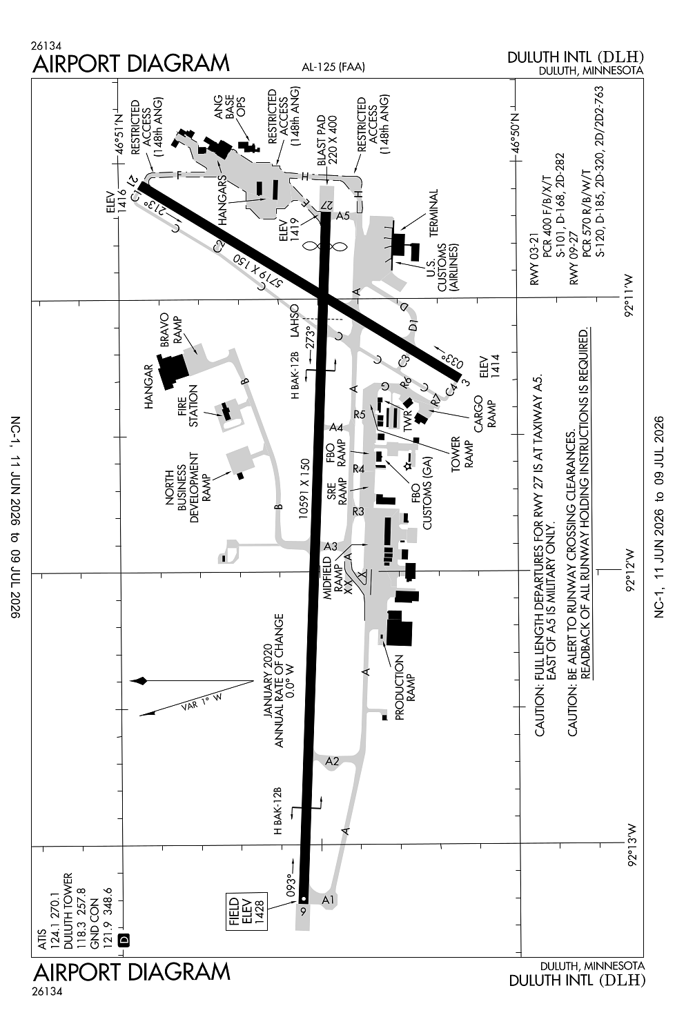
- Airport photos
- Crew car availability
- WiFi availability
Location:
Duluth, MN
Elevation:
1,427ft
Sectional:
Green Bay
Activation date:
Apr 1940
Fuel:
100LL, A, J8 (prices)
Runway 09/27:
10,591ft
Runway 03/21:
5,719ft
Access: Open to the public
Current Weather — VFR
-
Weather data is strictly informational and not for flight planning purposes.
-
METAR2026-07-20 03:55:00 CDT
Ceiling: Sky clear Wind: 220° @ 11kt Temperature: 71°F Dewpoint: 64°F Weather: N/A Visbility: 8SM Clouds: Few @ 3,600ft, Scattered @ 5,000ft Raw:METAR KDLH 200855Z 22011KT 8SM FEW036 SCT050 22/18 A2972 RMK AO2 SLP056 T02170178 58032 $ -
TAF2026-07-20 01:00:00 CDT – 2026-07-20 03:00:00 CDT
Ceiling: Sky clear Wind: 220° @ 11kt Weather: N/A Visbility: 6SM Clouds: Few @ 10,000ft Raw:TAF KDLH 200533Z 2006/2106 22011KT P6SM FEW100 FM200800 22010KT P6SM BKN090 PROB30 2008/2011 4SM -TSRA BKN060CB FM201400 25014G22KT P6SM SCT080 FM202200 27016G27KT P6SM SCT220 -
TAF2026-07-20 03:00:00 CDT – 2026-07-20 06:00:00 CDT
Ceiling: 6,000ft Wind: 000° @ kt Weather: Light thunderstorm rain Visbility: 4SM Clouds: Broken @ 6,000ft Raw:TAF KDLH 200533Z 2006/2106 22011KT P6SM FEW100 FM200800 22010KT P6SM BKN090 PROB30 2008/2011 4SM -TSRA BKN060CB FM201400 25014G22KT P6SM SCT080 FM202200 27016G27KT P6SM SCT220 -
TAF2026-07-20 03:00:00 CDT – 2026-07-20 09:00:00 CDT
Ceiling: 9,000ft Wind: 220° @ 10kt Weather: N/A Visbility: 6SM Clouds: Broken @ 9,000ft Raw:TAF KDLH 200533Z 2006/2106 22011KT P6SM FEW100 FM200800 22010KT P6SM BKN090 PROB30 2008/2011 4SM -TSRA BKN060CB FM201400 25014G22KT P6SM SCT080 FM202200 27016G27KT P6SM SCT220 -
TAF2026-07-20 09:00:00 CDT – 2026-07-20 17:00:00 CDT
Ceiling: Sky clear Wind: 250° @ 14kt, gusts 22kt Weather: N/A Visbility: 6SM Clouds: Scattered @ 8,000ft Raw:TAF KDLH 200533Z 2006/2106 22011KT P6SM FEW100 FM200800 22010KT P6SM BKN090 PROB30 2008/2011 4SM -TSRA BKN060CB FM201400 25014G22KT P6SM SCT080 FM202200 27016G27KT P6SM SCT220 -
TAF2026-07-20 17:00:00 CDT – 2026-07-21 01:00:00 CDT
Ceiling: Sky clear Wind: 270° @ 16kt, gusts 27kt Weather: N/A Visbility: 6SM Clouds: Scattered @ 22,000ft Raw:TAF KDLH 200533Z 2006/2106 22011KT P6SM FEW100 FM200800 22010KT P6SM BKN090 PROB30 2008/2011 4SM -TSRA BKN060CB FM201400 25014G22KT P6SM SCT080 FM202200 27016G27KT P6SM SCT220
Click/tap to add an annotation marker to the map
No webcams added yet.
Remarks
- Arff index d avbl h24 with 2 hr ppr - ctc ang 218-788-7434.
- Birds on & invof arpt.
- High speed military jet traffic not on ads-b operating in and above class d airspace from 3000' to 11,500' msl ctc dlh app for trfc adzys for transit rcmdd.
- When rwy 03/21 in use; twy c north of rwy 09/27 may be restricted by atc to acft with wingspans less than 49 ft.
- Jasu: 9(am32a-60) 2(a/m32a-86) 2(mc-11) 6(mc-2a) (mil).
Comments