Pirep is a free, collaborative database of all public and private airports. All pilots are welcome to contribute their local knowledge to any airport, no registration required.


No upcoming events. Is anything happening here soon?
Last updated: 2023-05-29 21:42:09 CDT
Airport Statistics
- WiFi availability
- Transient parking location
- Landing & tie-down fees
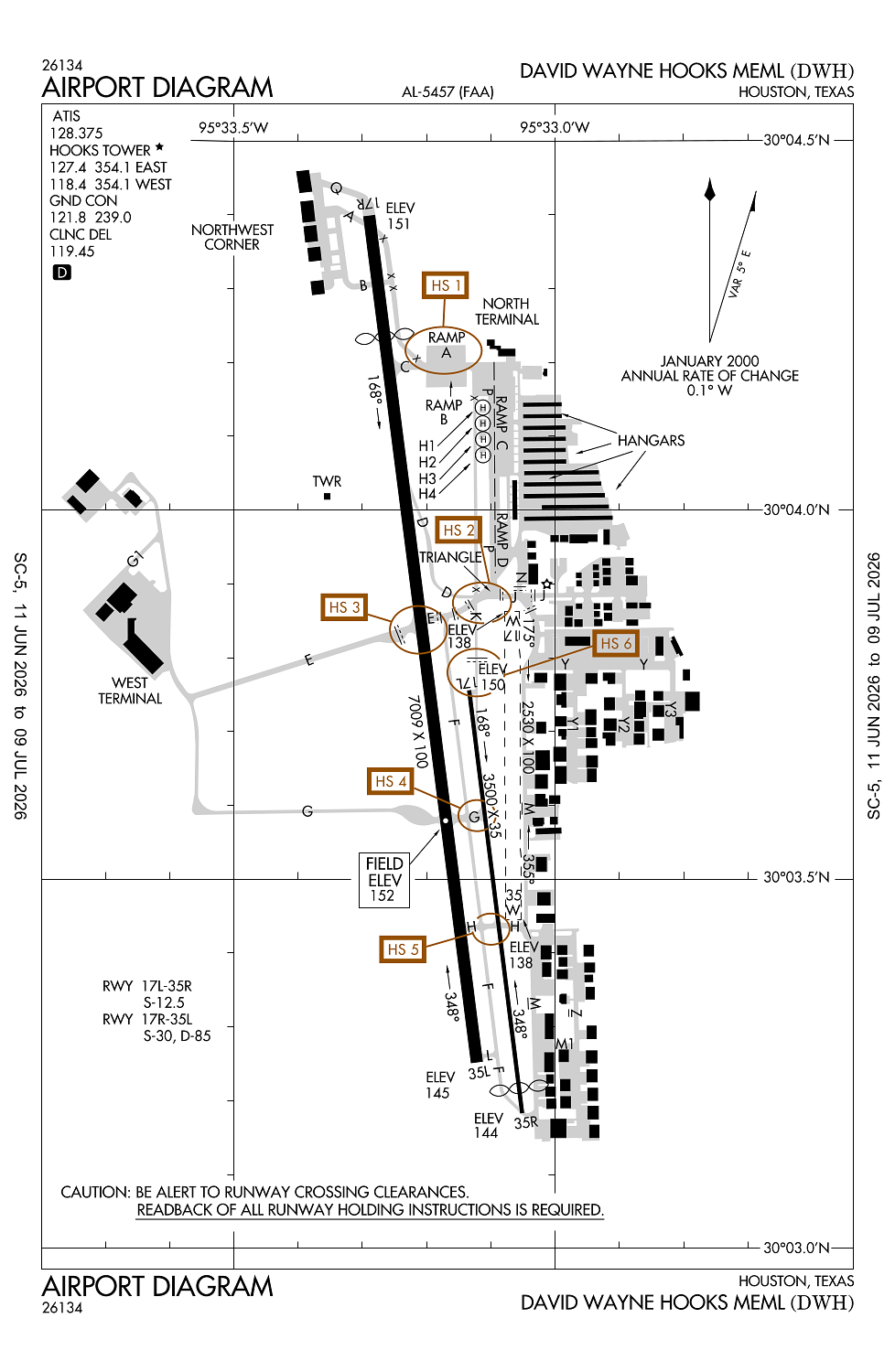
Location:
Houston, TX
Elevation:
152ft
Sectional:
Houston
Activation date:
Sep 1963
Fuel:
100LL, A1+ (prices)
Runway 17R/35L:
7,009ft
Runway 17L/35R:
3,500ft
Runway 17W/35W:
2,530ft
Runway H4:
50ft
Runway H1:
50ft
Runway H2:
50ft
Runway H3:
50ft
Access: Open to the public
This airport is privately owned but open to the public.
Similar Airports


Current Weather — VFR
-
Weather data is strictly informational and not for flight planning purposes.
-
METAR2026-07-21 14:53:00 CDT
Ceiling: Sky clear Wind: 260° @ 6kt Temperature: 93°F Dewpoint: 69°F Weather: N/A Visbility: 8SM Raw:METAR KDWH 211953Z 26006KT 8SM CLR 34/21 A2989 RMK AO2 SLP118 T03440206 -
TAF2026-07-20 07:00:00 CDT – 2026-07-20 09:00:00 CDT
Ceiling: Sky clear Wind: 240° @ 4kt Weather: Mist Visbility: 6SM Clouds: Few @ 1,500ft Raw:TAF KDWH 201120Z 2012/2112 24004KT 6SM BR FEW015 TEMPO 2012/2014 2SM BR FM201400 25007KT P6SM FEW035 FEW250 FM210000 21006KT P6SM FEW050 FEW250 -
TAF2026-07-20 07:00:00 CDT – 2026-07-20 09:00:00 CDT
Ceiling: Sky clear Wind: 000° @ kt Weather: Mist Visbility: 2SM Raw:TAF KDWH 201120Z 2012/2112 24004KT 6SM BR FEW015 TEMPO 2012/2014 2SM BR FM201400 25007KT P6SM FEW035 FEW250 FM210000 21006KT P6SM FEW050 FEW250 -
TAF2026-07-20 09:00:00 CDT – 2026-07-20 19:00:00 CDT
Ceiling: Sky clear Wind: 250° @ 7kt Weather: N/A Visbility: 6SM Clouds: Few @ 3,500ft, Few @ 25,000ft Raw:TAF KDWH 201120Z 2012/2112 24004KT 6SM BR FEW015 TEMPO 2012/2014 2SM BR FM201400 25007KT P6SM FEW035 FEW250 FM210000 21006KT P6SM FEW050 FEW250 -
TAF2026-07-20 19:00:00 CDT – 2026-07-21 07:00:00 CDT
Ceiling: Sky clear Wind: 210° @ 6kt Weather: N/A Visbility: 6SM Clouds: Few @ 5,000ft, Few @ 25,000ft Raw:TAF KDWH 201120Z 2012/2112 24004KT 6SM BR FEW015 TEMPO 2012/2014 2SM BR FM201400 25007KT P6SM FEW035 FEW250 FM210000 21006KT P6SM FEW050 FEW250
Click/tap to add an annotation marker to the map
No webcams added yet.
Remarks
- This airport has been surveyed by the national geodetic survey.
- Twys unlgtd.
- Aft ss lrg acft use twy p btn twys e & c.
- Hel practice area west of atct at or blw 600 ft.
- Four hel prkg pads lctd east of twy k.
Comments