Pirep is a free, collaborative database of all public and private airports. All pilots are welcome to contribute their local knowledge to any airport, no registration required.


Public
Undocumented
METAR / TAF
Edit Tags
No upcoming events. Is anything happening here soon?
Airport Statistics
- Tags
- Fuel pump location
- Airport map annotations
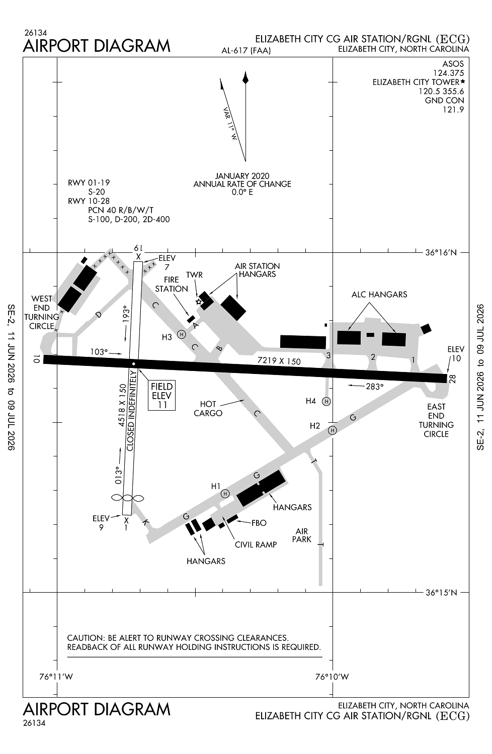
Location:
Elizabeth City, NC
Elevation:
10ft
Sectional:
Washington
Fuel:
100LL, A1+ (prices)
Runway 10/28:
7,219ft
Runway 01/19:
4,518ft
Runway H4:
100ft
Runway H1:
60ft
Runway H2:
50ft
Runway H3:
50ft
Access: Open to the public
Current Weather — VFR
-
Weather data is strictly informational and not for flight planning purposes.
-
METAR2026-07-16 06:54:00 EDT
Ceiling: Sky clear Wind: 230° @ 3kt Temperature: 71°F Dewpoint: 69°F Weather: N/A Visbility: 10SM Raw:METAR KECG 161054Z 23003KT 10SM CLR 22/21 A2997 RMK AO2 SLP148 T02170206 -
TAF2026-07-16 08:00:00 EDT – 2026-07-16 12:00:00 EDT
Ceiling: 25,000ft Wind: 230° @ 7kt Weather: N/A Visbility: 6SM Clouds: Broken @ 25,000ft Raw:TAF KECG 161120Z 1612/1712 23007KT P6SM BKN250 FM161600 18007KT P6SM BKN250 -
TAF2026-07-16 12:00:00 EDT – 2026-07-17 08:00:00 EDT
Ceiling: 25,000ft Wind: 180° @ 7kt Weather: N/A Visbility: 6SM Clouds: Broken @ 25,000ft Raw:TAF KECG 161120Z 1612/1712 23007KT P6SM BKN250 FM161600 18007KT P6SM BKN250
Click/tap to add an annotation marker to the map
No webcams added yet.
Remarks
- No line-of-sight between rwy ends.
- Acft with tail heights to 50 ft parked on apron first 2000 ft fm rwy 28 r side 250 ft fm rwy cntrln.
- Facilities and ramps north of rwy 10/28 rstrd to offl cg bus only.
- Intermittent tethered bln opns 3 nm se; dalgt hrs at 5000 ft.
- Seasonal low-flying agri acft based in the local area.
Comments