Pirep is a free, collaborative database of all public and private airports. All pilots are welcome to contribute their local knowledge to any airport, no registration required.
Events
Public
Undocumented
METAR / TAF
Edit Tags
Upcoming Events
-
Sat, Oct 31 2026 8:00am – Sun, Nov 1 2026 5:00pm
- Event webpage: https://wingsoverhouston.com/
Airport Statistics
- Airport photos
- Tags
- Crew car availability
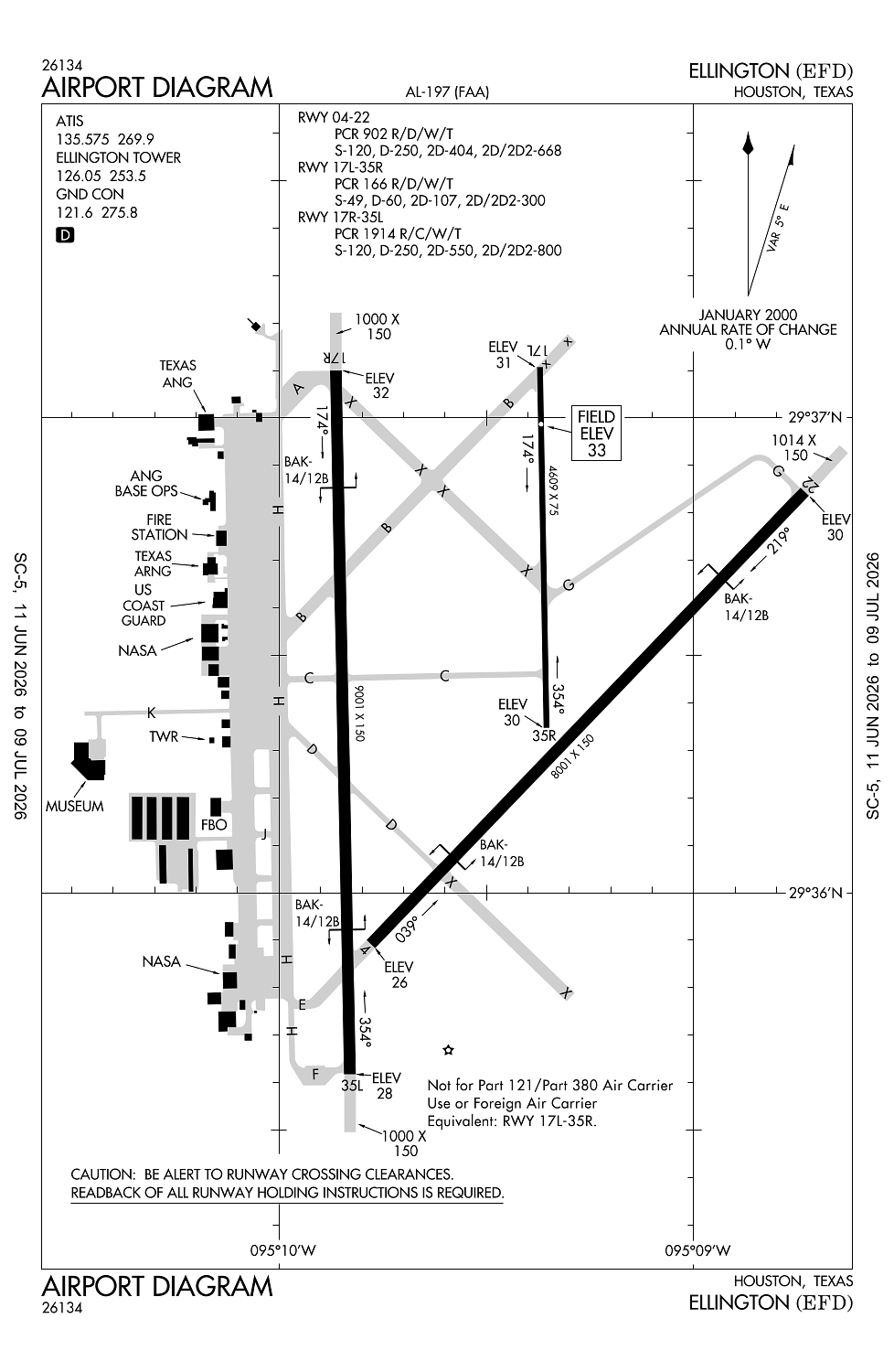
Location:
Houston, TX
Elevation:
32ft
Sectional:
Houston
Activation date:
Jun 1942
Fuel:
100LL, A (prices)
Runway 17R/35L:
9,001ft
Runway 04/22:
8,001ft
Runway 17L/35R:
4,609ft
Access: Open to the public
Current Weather — VFR
-
Weather data is strictly informational and not for flight planning purposes.
-
METAR2026-07-20 11:54:00 CDT
Ceiling: Sky clear Wind: 210° @ 6kt Temperature: 89°F Dewpoint: 75°F Weather: N/A Visbility: 10SM Raw:METAR KEFD 201654Z 21006KT 10SM CLR 32/24 A2997 -
TAF2026-07-20 09:00:00 CDT – 2026-07-20 10:00:00 CDT
Ceiling: 1,000ft Wind: Variable Weather: N/A Visbility: 6SM Clouds: Broken @ 1,000ft Raw:TAF AMD KEFD 201450Z 2014/2118 VRB06KT 9999 BKN010 QNH2995INS BECMG 2015/2016 VRB06KT 9999 SCT020 QNH2997INS TX35/2022Z TN29/2014Z -
TAF2026-07-20 10:00:00 CDT – 2026-07-21 13:00:00 CDT
Ceiling: Sky clear Wind: Variable Weather: N/A Visbility: 6SM Clouds: Scattered @ 2,000ft Raw:TAF AMD KEFD 201450Z 2014/2118 VRB06KT 9999 BKN010 QNH2995INS BECMG 2015/2016 VRB06KT 9999 SCT020 QNH2997INS TX35/2022Z TN29/2014Z
Click/tap to add an annotation marker to the map
No webcams added yet.
Remarks
- Provided arpt continues to be controlled by atct, rwy 04/22 is developed as primary rwy upgraded to pir capable of use by ang & nasa acft.
- Twy b unlgtd east of ry 17r/35l; dalgt use only.
- Be alert for mil acft at 1600 msl making ovhd apchs.
- 70 ft agl tanks lctd 1400 ft ne of ry 17r apch.
- Rwy 17l/35r btwn twys c & g - dual purpose rwy/twy with twy lgts.
Comments