Pirep is a free, collaborative database of all public and private airports. All pilots are welcome to contribute their local knowledge to any airport, no registration required.
Public
Undocumented
METAR / TAF
Edit Tags
No upcoming events. Is anything happening here soon?
Airport Statistics
- Airport map annotations
- Landing & tie-down fees
- Airport photos
Location:
Elko, NV
Elevation:
5,139ft
Sectional:
Salt Lake City
Activation date:
Apr 1940
Fuel:
100LL, A (prices)
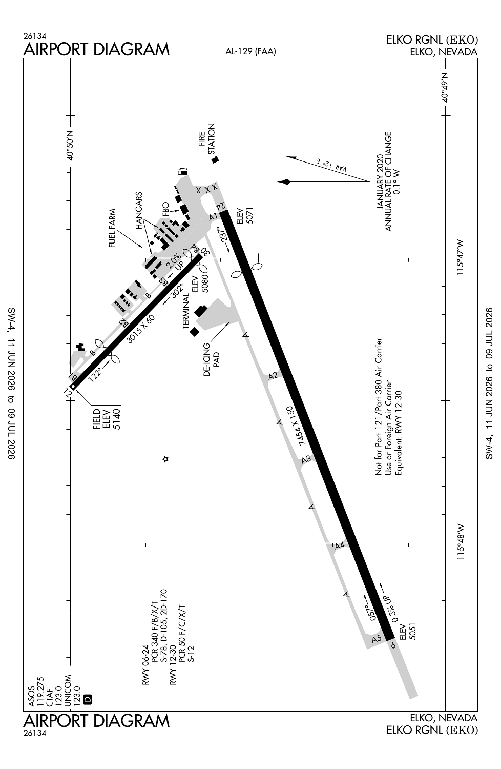
Runway 06/24:
7,454ft
Runway 12/30:
3,015ft
Access: Open to the public
Current Weather — VFR
-
Weather data is strictly informational and not for flight planning purposes.
-
METAR2026-07-20 17:09:00 PDT
Ceiling: 10,000ft Wind: 160° @ 21kt, gusts 33kt Temperature: 78°F Dewpoint: 55°F Weather: Light rain Visbility: 10SM Clouds: Overcast @ 10,000ft Raw:SPECI KEKO 210009Z AUTO 16021G33KT 10SM -RA OVC100 26/13 A3009 RMK AO2 PK WND 15034/2359 LTG DSNT NE AND S RAB06 P0000 T02610133 -
TAF2026-07-20 17:00:00 PDT – 2026-07-20 21:00:00 PDT
Ceiling: 12,000ft Wind: 200° @ 7kt Weather: Light rain showers Visbility: 6SM Clouds: Broken @ 12,000ft Raw:TAF KEKO 202330Z 2100/2124 20007KT P6SM -SHRA BKN120 PROB30 2100/2104 VRB15G30KT 5SM -TSRA OVC100CB FM210400 21010KT P6SM VCSH BKN100 FM210600 22003KT P6SM SCT120 BKN200 FM211800 22007KT P6SM BKN120 PROB30 2118/2124 VRB15G25KT 5SM -TSRA OVC100CB -
TAF2026-07-20 17:00:00 PDT – 2026-07-20 21:00:00 PDT
Ceiling: 10,000ft Wind: Variable, gusts 30kt Weather: Light thunderstorm rain Visbility: 5SM Clouds: Overcast @ 10,000ft Raw:TAF KEKO 202330Z 2100/2124 20007KT P6SM -SHRA BKN120 PROB30 2100/2104 VRB15G30KT 5SM -TSRA OVC100CB FM210400 21010KT P6SM VCSH BKN100 FM210600 22003KT P6SM SCT120 BKN200 FM211800 22007KT P6SM BKN120 PROB30 2118/2124 VRB15G25KT 5SM -TSRA OVC100CB -
TAF2026-07-20 21:00:00 PDT – 2026-07-20 23:00:00 PDT
Ceiling: 10,000ft Wind: 210° @ 10kt Weather: Showers in vicinity Visbility: 6SM Clouds: Broken @ 10,000ft Raw:TAF KEKO 202330Z 2100/2124 20007KT P6SM -SHRA BKN120 PROB30 2100/2104 VRB15G30KT 5SM -TSRA OVC100CB FM210400 21010KT P6SM VCSH BKN100 FM210600 22003KT P6SM SCT120 BKN200 FM211800 22007KT P6SM BKN120 PROB30 2118/2124 VRB15G25KT 5SM -TSRA OVC100CB -
TAF2026-07-20 23:00:00 PDT – 2026-07-21 11:00:00 PDT
Ceiling: 20,000ft Wind: 220° @ 3kt Weather: N/A Visbility: 6SM Clouds: Scattered @ 12,000ft, Broken @ 20,000ft Raw:TAF KEKO 202330Z 2100/2124 20007KT P6SM -SHRA BKN120 PROB30 2100/2104 VRB15G30KT 5SM -TSRA OVC100CB FM210400 21010KT P6SM VCSH BKN100 FM210600 22003KT P6SM SCT120 BKN200 FM211800 22007KT P6SM BKN120 PROB30 2118/2124 VRB15G25KT 5SM -TSRA OVC100CB -
TAF2026-07-21 11:00:00 PDT – 2026-07-21 17:00:00 PDT
Ceiling: 12,000ft Wind: 220° @ 7kt Weather: N/A Visbility: 6SM Clouds: Broken @ 12,000ft Raw:TAF KEKO 202330Z 2100/2124 20007KT P6SM -SHRA BKN120 PROB30 2100/2104 VRB15G30KT 5SM -TSRA OVC100CB FM210400 21010KT P6SM VCSH BKN100 FM210600 22003KT P6SM SCT120 BKN200 FM211800 22007KT P6SM BKN120 PROB30 2118/2124 VRB15G25KT 5SM -TSRA OVC100CB -
TAF2026-07-21 11:00:00 PDT – 2026-07-21 17:00:00 PDT
Ceiling: 10,000ft Wind: Variable, gusts 25kt Weather: Light thunderstorm rain Visbility: 5SM Clouds: Overcast @ 10,000ft Raw:TAF KEKO 202330Z 2100/2124 20007KT P6SM -SHRA BKN120 PROB30 2100/2104 VRB15G30KT 5SM -TSRA OVC100CB FM210400 21010KT P6SM VCSH BKN100 FM210600 22003KT P6SM SCT120 BKN200 FM211800 22007KT P6SM BKN120 PROB30 2118/2124 VRB15G25KT 5SM -TSRA OVC100CB
Click/tap to add an annotation marker to the map
No webcams added yet.
Remarks
- Rwy 24 designated calm wind rwy.
- Ppr for all acft opns over 100000 lbs call 775-777-7190.
- Tkof only on rwy 12. land only on rwy 30.
- No tgl rwy 12/30.
- Steep slope/gradient rwy 30 upward.
Comments