Pirep is a free, collaborative database of all public and private airports. All pilots are welcome to contribute their local knowledge to any airport, no registration required.
Undocumented
METAR / TAF
Edit Tags
No upcoming events. Is anything happening here soon?
Airport Statistics
- Transient parking location
- Fuel pump location
- Crew car availability
Location:
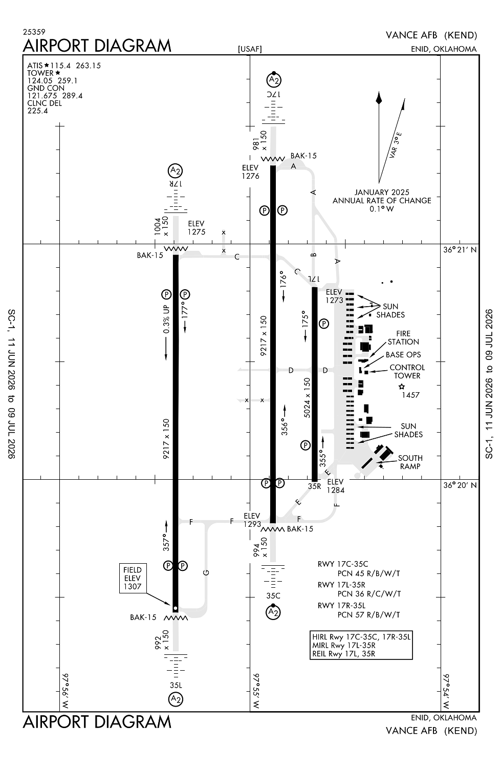
Enid, OK
Elevation:
1,312ft
Sectional:
Wichita
Activation date:
Jul 1943
Fuel:
None
Runway 17C/35C:
9,217ft
Runway 17R/35L:
9,217ft
Runway 17L/35R:
5,024ft
Access: Private to everyone
This is a military facility.
Current Weather — VFR
-
Weather data is strictly informational and not for flight planning purposes.
-
METAR2026-07-20 01:55:00 CDT
Ceiling: Sky clear Wind: 180° @ 8kt Temperature: 79°F Dewpoint: 70°F Weather: N/A Visbility: 10SM Raw:METAR KEND 200655Z AUTO 18008KT 10SM CLR 26/22 A2990 RMK AO2 SLP108 T02640216 $ -
TAF2026-07-19 16:00:00 CDT – 2026-07-19 19:00:00 CDT
Ceiling: Sky clear Wind: 140° @ 10kt, gusts 20kt Weather: N/A Visbility: 6SM Clouds: Scattered @ 7,000ft Raw:TAF AMD KEND 192138Z 1921/2024 14010G20KT 9999 SCT070 QNH2987INS BECMG 2000/2001 18008KT 9999 FEW100 QNH2985INS BECMG 2018/2019 19010G20KT 9999 SCT080 QNH2983INS TX36/1923Z TN25/2012Z LAST NO AMDS AFT 1921 NEXT 2010 -
TAF2026-07-19 19:00:00 CDT – 2026-07-20 13:00:00 CDT
Ceiling: Sky clear Wind: 180° @ 8kt Weather: N/A Visbility: 6SM Clouds: Few @ 10,000ft Raw:TAF AMD KEND 192138Z 1921/2024 14010G20KT 9999 SCT070 QNH2987INS BECMG 2000/2001 18008KT 9999 FEW100 QNH2985INS BECMG 2018/2019 19010G20KT 9999 SCT080 QNH2983INS TX36/1923Z TN25/2012Z LAST NO AMDS AFT 1921 NEXT 2010 -
TAF2026-07-20 13:00:00 CDT – 2026-07-20 19:00:00 CDT
Ceiling: Sky clear Wind: 190° @ 10kt, gusts 20kt Weather: N/A Visbility: 6SM Clouds: Scattered @ 8,000ft Raw:TAF AMD KEND 192138Z 1921/2024 14010G20KT 9999 SCT070 QNH2987INS BECMG 2000/2001 18008KT 9999 FEW100 QNH2985INS BECMG 2018/2019 19010G20KT 9999 SCT080 QNH2983INS TX36/1923Z TN25/2012Z LAST NO AMDS AFT 1921 NEXT 2010
Click/tap to add an annotation marker to the map
No webcams added yet.
Remarks
- Rstd: durg vmc dep rmn blw 2300 ft until der to ensure sepn fm vfr ovhd pat unless otrw cleared by atc.
- Bearing strength rwy 04-22: st127 sbtt379 ddt547.
- Bearing strength rwy 17l-35r: trt544.
- Bearing strength rwy 17r-35l: trt540.
- Bearing strength rwy 17c-35c: sbtt535 ddt790 trt469.
Comments