Pirep is a free, collaborative database of all public and private airports. All pilots are welcome to contribute their local knowledge to any airport, no registration required.
Undocumented
METAR / TAF
Edit Tags
No upcoming events. Is anything happening here soon?
Airport Statistics
- Local flying clubs
- Fuel pump location
- Crew car availability
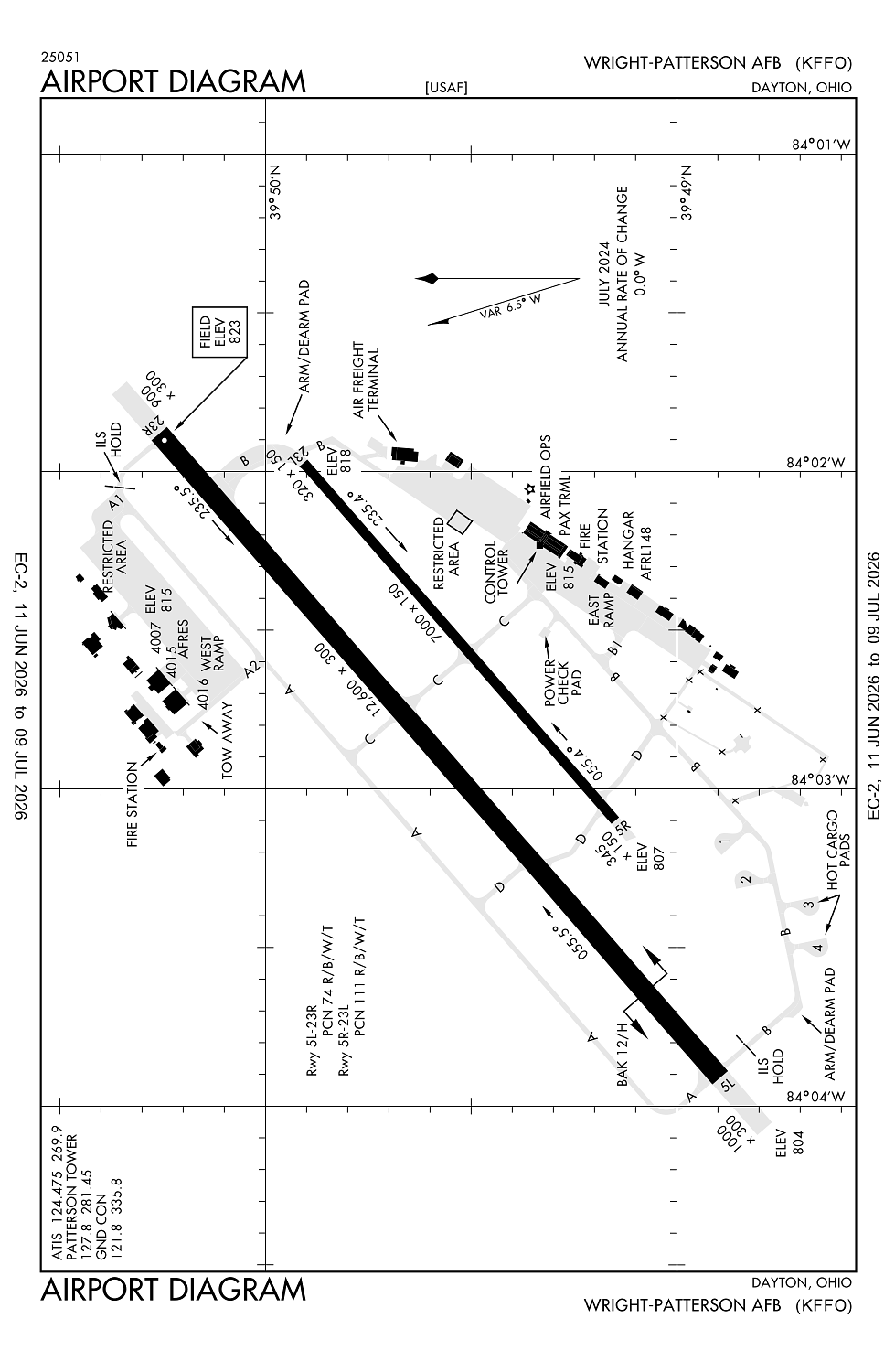
Location:
Dayton, OH
Elevation:
823ft
Sectional:
Cincinnati
Activation date:
Aug 1943
Fuel:
None
Runway 05L/23R:
12,600ft
Runway 05R/23L:
7,000ft
Access: Private to everyone
This is a military facility.
Current Weather — VFR
-
Weather data is strictly informational and not for flight planning purposes.
-
METAR2026-07-21 01:55:00 EDT
Ceiling: Sky clear Wind: Calm Temperature: 75°F Dewpoint: 69°F Weather: N/A Visbility: 10SM Raw:METAR KFFO 210555Z AUTO 00000KT 10SM CLR 24/21 A2980 RMK AO2 SLP086 T02390210 10289 20236 55007 -
TAF2026-07-20 23:00:00 EDT – 2026-07-21 05:00:00 EDT
Ceiling: 22,000ft Wind: 230° @ 7kt Weather: N/A Visbility: 6SM Clouds: Broken @ 22,000ft Raw:TAF KFFO 210300Z 2103/2209 23007KT 9999 BKN220 510103 QNH2973INS BECMG 2109/2111 24009KT 9000 -SHRA BKN025 BKN060 OVC100 QNH2973INS BECMG 2112/2113 24012KT 9000 -TSRA BKN020CB OVC035 QNH2969INS TEMPO 2113/2117 VRB25G35KT 3200 TSRA BR FEW005 BKN018CB OVC025 BECMG 2117/2118 25012KT 9999 VCSH BKN035 BKN120 BKN220 QNH2967INS TEMPO 2118/2123 25015G25KT 9000 -SHRA BKN025 OVC080 BECMG 2123/2124 27009KT 9999 NSW SCT045 QNH2970INS TX29/2121Z TN22/2110Z -
TAF2026-07-21 05:00:00 EDT – 2026-07-21 08:00:00 EDT
Ceiling: 2,500ft Wind: 240° @ 9kt Weather: Light rain showers Visbility: 5SM Clouds: Broken @ 2,500ft, Broken @ 6,000ft, Overcast @ 10,000ft Raw:TAF KFFO 210300Z 2103/2209 23007KT 9999 BKN220 510103 QNH2973INS BECMG 2109/2111 24009KT 9000 -SHRA BKN025 BKN060 OVC100 QNH2973INS BECMG 2112/2113 24012KT 9000 -TSRA BKN020CB OVC035 QNH2969INS TEMPO 2113/2117 VRB25G35KT 3200 TSRA BR FEW005 BKN018CB OVC025 BECMG 2117/2118 25012KT 9999 VCSH BKN035 BKN120 BKN220 QNH2967INS TEMPO 2118/2123 25015G25KT 9000 -SHRA BKN025 OVC080 BECMG 2123/2124 27009KT 9999 NSW SCT045 QNH2970INS TX29/2121Z TN22/2110Z -
TAF2026-07-21 08:00:00 EDT – 2026-07-21 13:00:00 EDT
Ceiling: 2,000ft Wind: 240° @ 12kt Weather: Light thunderstorm rain Visbility: 5SM Clouds: Broken @ 2,000ft, Overcast @ 3,500ft Raw:TAF KFFO 210300Z 2103/2209 23007KT 9999 BKN220 510103 QNH2973INS BECMG 2109/2111 24009KT 9000 -SHRA BKN025 BKN060 OVC100 QNH2973INS BECMG 2112/2113 24012KT 9000 -TSRA BKN020CB OVC035 QNH2969INS TEMPO 2113/2117 VRB25G35KT 3200 TSRA BR FEW005 BKN018CB OVC025 BECMG 2117/2118 25012KT 9999 VCSH BKN035 BKN120 BKN220 QNH2967INS TEMPO 2118/2123 25015G25KT 9000 -SHRA BKN025 OVC080 BECMG 2123/2124 27009KT 9999 NSW SCT045 QNH2970INS TX29/2121Z TN22/2110Z -
TAF2026-07-21 09:00:00 EDT – 2026-07-21 13:00:00 EDT
Ceiling: 1,800ft Wind: Variable, gusts 35kt Weather: Thunderstorm rain, mist Visbility: 1SM Clouds: Few @ 500ft, Broken @ 1,800ft, Overcast @ 2,500ft Raw:TAF KFFO 210300Z 2103/2209 23007KT 9999 BKN220 510103 QNH2973INS BECMG 2109/2111 24009KT 9000 -SHRA BKN025 BKN060 OVC100 QNH2973INS BECMG 2112/2113 24012KT 9000 -TSRA BKN020CB OVC035 QNH2969INS TEMPO 2113/2117 VRB25G35KT 3200 TSRA BR FEW005 BKN018CB OVC025 BECMG 2117/2118 25012KT 9999 VCSH BKN035 BKN120 BKN220 QNH2967INS TEMPO 2118/2123 25015G25KT 9000 -SHRA BKN025 OVC080 BECMG 2123/2124 27009KT 9999 NSW SCT045 QNH2970INS TX29/2121Z TN22/2110Z -
TAF2026-07-21 13:00:00 EDT – 2026-07-21 19:00:00 EDT
Ceiling: 3,500ft Wind: 250° @ 12kt Weather: Showers in vicinity Visbility: 6SM Clouds: Broken @ 3,500ft, Broken @ 12,000ft, Broken @ 22,000ft Raw:TAF KFFO 210300Z 2103/2209 23007KT 9999 BKN220 510103 QNH2973INS BECMG 2109/2111 24009KT 9000 -SHRA BKN025 BKN060 OVC100 QNH2973INS BECMG 2112/2113 24012KT 9000 -TSRA BKN020CB OVC035 QNH2969INS TEMPO 2113/2117 VRB25G35KT 3200 TSRA BR FEW005 BKN018CB OVC025 BECMG 2117/2118 25012KT 9999 VCSH BKN035 BKN120 BKN220 QNH2967INS TEMPO 2118/2123 25015G25KT 9000 -SHRA BKN025 OVC080 BECMG 2123/2124 27009KT 9999 NSW SCT045 QNH2970INS TX29/2121Z TN22/2110Z -
TAF2026-07-21 14:00:00 EDT – 2026-07-21 19:00:00 EDT
Ceiling: 2,500ft Wind: 250° @ 15kt, gusts 25kt Weather: Light rain showers Visbility: 5SM Clouds: Broken @ 2,500ft, Overcast @ 8,000ft Raw:TAF KFFO 210300Z 2103/2209 23007KT 9999 BKN220 510103 QNH2973INS BECMG 2109/2111 24009KT 9000 -SHRA BKN025 BKN060 OVC100 QNH2973INS BECMG 2112/2113 24012KT 9000 -TSRA BKN020CB OVC035 QNH2969INS TEMPO 2113/2117 VRB25G35KT 3200 TSRA BR FEW005 BKN018CB OVC025 BECMG 2117/2118 25012KT 9999 VCSH BKN035 BKN120 BKN220 QNH2967INS TEMPO 2118/2123 25015G25KT 9000 -SHRA BKN025 OVC080 BECMG 2123/2124 27009KT 9999 NSW SCT045 QNH2970INS TX29/2121Z TN22/2110Z -
TAF2026-07-21 19:00:00 EDT – 2026-07-22 05:00:00 EDT
Ceiling: Sky clear Wind: 270° @ 9kt Weather: N/A Visbility: 6SM Clouds: Scattered @ 4,500ft Raw:TAF KFFO 210300Z 2103/2209 23007KT 9999 BKN220 510103 QNH2973INS BECMG 2109/2111 24009KT 9000 -SHRA BKN025 BKN060 OVC100 QNH2973INS BECMG 2112/2113 24012KT 9000 -TSRA BKN020CB OVC035 QNH2969INS TEMPO 2113/2117 VRB25G35KT 3200 TSRA BR FEW005 BKN018CB OVC025 BECMG 2117/2118 25012KT 9999 VCSH BKN035 BKN120 BKN220 QNH2967INS TEMPO 2118/2123 25015G25KT 9000 -SHRA BKN025 OVC080 BECMG 2123/2124 27009KT 9999 NSW SCT045 QNH2970INS TX29/2121Z TN22/2110Z
Click/tap to add an annotation marker to the map
No webcams added yet.
Remarks
- Caution: portions of flameout & overhead tfc pat not vis fm twr.
- Misc: exp dep fr ry 23r at twy 'b' int 11,600 ft avbl; if full len rqr, rq back-taxi fm twr.
- Caution: unlgtd obst sur afld.
- Caution: bird watch condition phase i (nov-jun) indicates lgt bird act, phase ii (jul-oct) indicates hvy bird act nml associated with migratory season.
- Misc: unlgtd abandoned twr w side fld.
Comments