Pirep is a free, collaborative database of all public and private airports. All pilots are welcome to contribute their local knowledge to any airport, no registration required.


Undocumented
METAR / TAF
Edit Tags
No upcoming events. Is anything happening here soon?
Airport Statistics
- Landing & tie-down fees
- General description
- Crew car availability
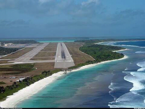
Location:
Camp Justice, IO
Elevation:
13ft
Activation date:
May 2009
Fuel:
None
Runway 13/31:
12,004ft
Runway 13L/31R:
9,204ft
Access: Private to everyone
This is a military facility.
Current Weather — VFR
-
Weather data is strictly informational and not for flight planning purposes.
-
METAR2026-07-21 12:55:00 +06
Ceiling: 9,000ft Wind: 130° @ 16kt, gusts 22kt Temperature: 84°F Dewpoint: 71°F Weather: N/A Visbility: 6SM Clouds: Few @ 2,500ft, Broken @ 9,000ft Raw:METAR FJDG 210655Z 13016G22KT 9999 FEW025 BKN090 29/22 A2993 RMK SLP135 ALSTG/SLP ESTMD T02940222 -
TAF2026-07-21 07:00:00 +06 – 2026-07-22 13:00:00 +06
Ceiling: 10,000ft Wind: 120° @ 15kt Weather: N/A Visbility: 6SM Clouds: Few @ 2,000ft, Scattered @ 5,000ft, Broken @ 10,000ft Raw:TAF FJDG 210100Z 2101/2207 12015KT 9999 FEW020 SCT050 BKN100 QNH2985INS TEMPO 2200/2207 12018G25KT TX30/2106Z TN25/2122Z -
TAF2026-07-22 06:00:00 +06 – 2026-07-22 13:00:00 +06
Ceiling: Sky clear Wind: 120° @ 18kt, gusts 25kt Weather: N/A Visbility: SM Raw:TAF FJDG 210100Z 2101/2207 12015KT 9999 FEW020 SCT050 BKN100 QNH2985INS TEMPO 2200/2207 12018G25KT TX30/2106Z TN25/2122Z
Click/tap to add an annotation marker to the map
No webcams added yet.
Remarks
- The information and data contained herein has been provided by entities outside of, and not under the control of, the federal aviation administration (faa). source dod flip.
- Extended-range twin-engine operations (etops).
- Service: lgt-papi rwy 13 gs 3.5 degs, rwy 13 gs 3.0 degs.
- Nsf diego garcia shall not be listed as a planned etops or enroute alternate airfield by any commercial or private aircraft.
- Arff index: icao cat 10.
- Prior sked ops only.
- For calp coord ctc base opsnsfdg_air_traffic_control@us.navy.mil. dsn 315-370-3322, co11-246-370-3322.
- Flt plans shall be filed 4 hr in advn due to msg tfc relay dly. acft trmtg fjdg plan fuel for min one hr hldg dur periods of hvy rain. twr has no radar cpblty and prvds no ifr sepn.
Comments