Pirep is a free, collaborative database of all public and private airports. All pilots are welcome to contribute their local knowledge to any airport, no registration required.
Undocumented
METAR / TAF
Edit Tags
No upcoming events. Is anything happening here soon?
Airport Statistics
- General description
- Fuel pump location
- Tags
Location:
Fort Drum, NY
Elevation:
689ft
Sectional:
Montreal
Fuel:
None
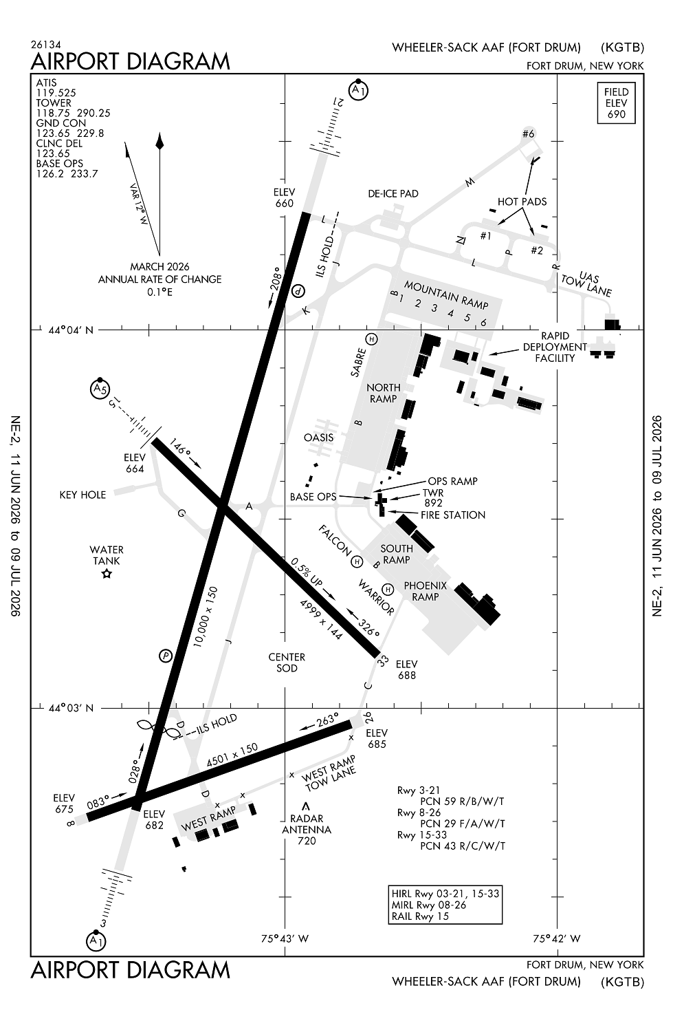
Runway 03/21:
10,000ft
Runway 15/33:
5,002ft
Runway 08/26:
4,501ft
Access: Private to everyone
This is a military facility.
Current Weather — VFR
-
Weather data is strictly informational and not for flight planning purposes.
-
METAR2026-07-20 14:55:00 EDT
Ceiling: Sky clear Wind: 290° @ 7kt Temperature: 77°F Dewpoint: 50°F Weather: N/A Visbility: 10SM Raw:METAR KGTB 201855Z AUTO 29007KT 10SM CLR 25/10 A2991 RMK AO2 SLP126 T02510102 $ -
TAF2026-07-20 13:00:00 EDT – 2026-07-20 19:00:00 EDT
Ceiling: Sky clear Wind: 260° @ 10kt Weather: N/A Visbility: 6SM Clouds: Few @ 5,000ft, Few @ 15,000ft Raw:TAF KGTB 201700Z 2017/2123 26010KT 9999 FEW050 FEW150 QNH2986INS BECMG 2023/2024 VRB06KT 9999 BKN200 QNH2977INS BECMG 2107/2108 15010G20KT 9999 FEW050 BKN150 QNH2963INS BECMG 2116/2117 18015G25KT 9000 -SHRA BKN050 520003 QNH2956INS TEMPO 2118/2121 18015G30KT 4800 TSRA BKN020CB BECMG 2122/2123 17010G20KT 9000 -SHRA BKN050 QNH2956INS TX25/2020Z TN17/2102Z -
TAF2026-07-20 19:00:00 EDT – 2026-07-21 03:00:00 EDT
Ceiling: 20,000ft Wind: Variable Weather: N/A Visbility: 6SM Clouds: Broken @ 20,000ft Raw:TAF KGTB 201700Z 2017/2123 26010KT 9999 FEW050 FEW150 QNH2986INS BECMG 2023/2024 VRB06KT 9999 BKN200 QNH2977INS BECMG 2107/2108 15010G20KT 9999 FEW050 BKN150 QNH2963INS BECMG 2116/2117 18015G25KT 9000 -SHRA BKN050 520003 QNH2956INS TEMPO 2118/2121 18015G30KT 4800 TSRA BKN020CB BECMG 2122/2123 17010G20KT 9000 -SHRA BKN050 QNH2956INS TX25/2020Z TN17/2102Z -
TAF2026-07-21 03:00:00 EDT – 2026-07-21 12:00:00 EDT
Ceiling: 15,000ft Wind: 150° @ 10kt, gusts 20kt Weather: N/A Visbility: 6SM Clouds: Few @ 5,000ft, Broken @ 15,000ft Raw:TAF KGTB 201700Z 2017/2123 26010KT 9999 FEW050 FEW150 QNH2986INS BECMG 2023/2024 VRB06KT 9999 BKN200 QNH2977INS BECMG 2107/2108 15010G20KT 9999 FEW050 BKN150 QNH2963INS BECMG 2116/2117 18015G25KT 9000 -SHRA BKN050 520003 QNH2956INS TEMPO 2118/2121 18015G30KT 4800 TSRA BKN020CB BECMG 2122/2123 17010G20KT 9000 -SHRA BKN050 QNH2956INS TX25/2020Z TN17/2102Z -
TAF2026-07-21 12:00:00 EDT – 2026-07-21 18:00:00 EDT
Ceiling: 5,000ft Wind: 180° @ 15kt, gusts 25kt Weather: Light rain showers Visbility: 5SM Clouds: Broken @ 5,000ft Raw:TAF KGTB 201700Z 2017/2123 26010KT 9999 FEW050 FEW150 QNH2986INS BECMG 2023/2024 VRB06KT 9999 BKN200 QNH2977INS BECMG 2107/2108 15010G20KT 9999 FEW050 BKN150 QNH2963INS BECMG 2116/2117 18015G25KT 9000 -SHRA BKN050 520003 QNH2956INS TEMPO 2118/2121 18015G30KT 4800 TSRA BKN020CB BECMG 2122/2123 17010G20KT 9000 -SHRA BKN050 QNH2956INS TX25/2020Z TN17/2102Z -
TAF2026-07-21 14:00:00 EDT – 2026-07-21 17:00:00 EDT
Ceiling: 2,000ft Wind: 180° @ 15kt, gusts 30kt Weather: Thunderstorm rain Visbility: 2SM Clouds: Broken @ 2,000ft Raw:TAF KGTB 201700Z 2017/2123 26010KT 9999 FEW050 FEW150 QNH2986INS BECMG 2023/2024 VRB06KT 9999 BKN200 QNH2977INS BECMG 2107/2108 15010G20KT 9999 FEW050 BKN150 QNH2963INS BECMG 2116/2117 18015G25KT 9000 -SHRA BKN050 520003 QNH2956INS TEMPO 2118/2121 18015G30KT 4800 TSRA BKN020CB BECMG 2122/2123 17010G20KT 9000 -SHRA BKN050 QNH2956INS TX25/2020Z TN17/2102Z -
TAF2026-07-21 18:00:00 EDT – 2026-07-21 19:00:00 EDT
Ceiling: 5,000ft Wind: 170° @ 10kt, gusts 20kt Weather: Light rain showers Visbility: 5SM Clouds: Broken @ 5,000ft Raw:TAF KGTB 201700Z 2017/2123 26010KT 9999 FEW050 FEW150 QNH2986INS BECMG 2023/2024 VRB06KT 9999 BKN200 QNH2977INS BECMG 2107/2108 15010G20KT 9999 FEW050 BKN150 QNH2963INS BECMG 2116/2117 18015G25KT 9000 -SHRA BKN050 520003 QNH2956INS TEMPO 2118/2121 18015G30KT 4800 TSRA BKN020CB BECMG 2122/2123 17010G20KT 9000 -SHRA BKN050 QNH2956INS TX25/2020Z TN17/2102Z
Click/tap to add an annotation marker to the map
No webcams added yet.
Remarks
- Lctd on 847'msl tower west of rwy 8.
- Service-l-aoe jasu-3(asu600-270-ddp). fuel-a++ (mil); avbl 1400-0300z++mon-fri, exc hol, ot pn.
- Tran alert: no catering, cleaning, lav, trash removal, water, or crew trnsp svc avbl.
- Rstd: ppr ctc base ops dsn 772-5681 c315-772-5681/5682. tenant acft have priority for lcl pat ops, tran may be ltd. rwy 15-33.twy g rstd to c130 or smaller. sod ldg/ops rstd to cntr, sod. oasis rst to tenant r/w hot reful ops, ldg/dep prohibited when clsd. twy b btn twy a and n ramp clsd.
- Ctn: uas opr wi 20nm kgtb sfc-fl290. extsy mil acft activity vcnty arpt mil acft refer to flip ap/1 prior to ops on fort drum or wi r-5201. narrow twy a,b int arc 40 ft wide. n ramp edge lgt us. twy b edge lgt us btn twy a and sabre helipad. w ramp unlgtd. rsc not mntn when base ops is clsd. wildlife haz, refer to ap/1.
Comments