Pirep is a free, collaborative database of all public and private airports. All pilots are welcome to contribute their local knowledge to any airport, no registration required.
Undocumented
METAR / TAF
Edit Tags
No upcoming events. Is anything happening here soon?
Airport Statistics
- Crew car availability
- Airport map annotations
- WiFi availability
Location:
Guernsey, WY
Elevation:
4,401ft
Sectional:
Cheyenne
Activation date:
Sep 1947
Fuel:
A (prices)
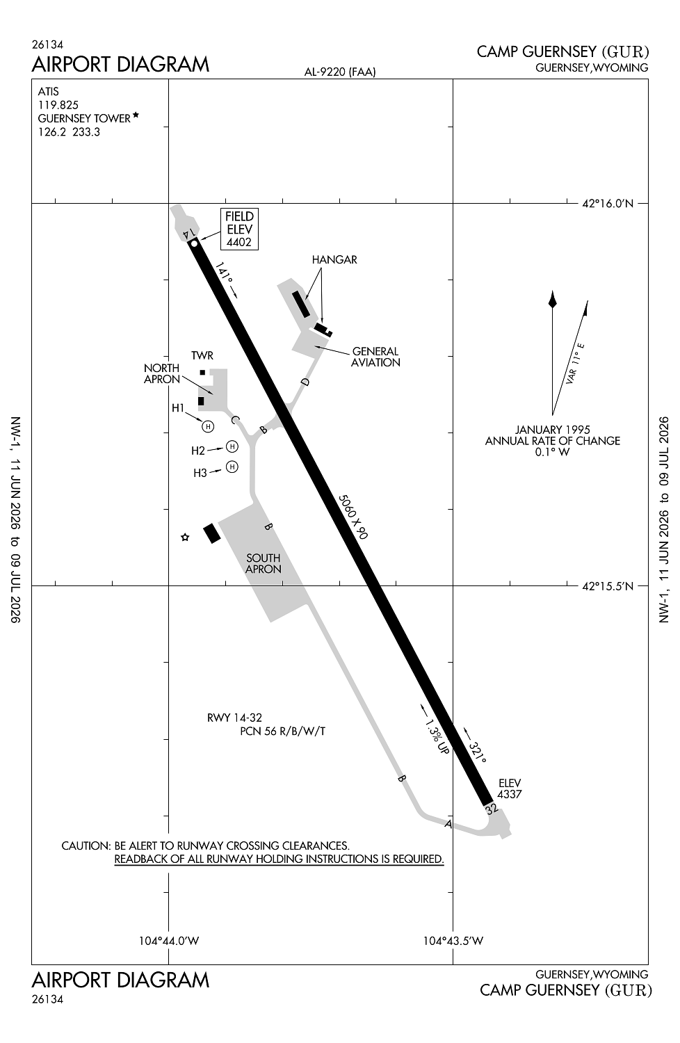
Runway 14/32:
5,060ft
Runway H1:
80ft
Runway H2:
80ft
Runway H3:
80ft
Access: Open to the public
Current Weather — VFR
-
Weather data is strictly informational and not for flight planning purposes.
-
METAR2026-07-20 13:55:00 MDT
Ceiling: Sky clear Wind: 100° @ 10kt, gusts 17kt Temperature: 102°F Dewpoint: 52°F Weather: N/A Visbility: 10SM Raw:METAR KGUR 201955Z AUTO 10010G17KT 10SM CLR 39/12 A2999 RMK AO2 SLP108 T03940115 -
TAF2026-07-20 07:00:00 MDT – 2026-07-20 16:00:00 MDT
Ceiling: Sky clear Wind: Variable Weather: N/A Visbility: 6SM Clouds: @ ft Raw:TAF KGUR 201300Z 2013/2119 VRB06KT 9999 SKC QNH3002INS BECMG 2022/2023 06009KT 9000 -SHRA BKN120 QNH3007INS BECMG 2102/2103 VRB06KT 9999 NSW SCT100 QNH3010INS BECMG 2117/2118 13010G20KT 9999 FEW110 QNH3012INS TX39/2022Z TN19/2112Z -
TAF2026-07-20 16:00:00 MDT – 2026-07-20 20:00:00 MDT
Ceiling: 12,000ft Wind: 060° @ 9kt Weather: Light rain showers Visbility: 5SM Clouds: Broken @ 12,000ft Raw:TAF KGUR 201300Z 2013/2119 VRB06KT 9999 SKC QNH3002INS BECMG 2022/2023 06009KT 9000 -SHRA BKN120 QNH3007INS BECMG 2102/2103 VRB06KT 9999 NSW SCT100 QNH3010INS BECMG 2117/2118 13010G20KT 9999 FEW110 QNH3012INS TX39/2022Z TN19/2112Z -
TAF2026-07-20 20:00:00 MDT – 2026-07-21 11:00:00 MDT
Ceiling: Sky clear Wind: Variable Weather: N/A Visbility: 6SM Clouds: Scattered @ 10,000ft Raw:TAF KGUR 201300Z 2013/2119 VRB06KT 9999 SKC QNH3002INS BECMG 2022/2023 06009KT 9000 -SHRA BKN120 QNH3007INS BECMG 2102/2103 VRB06KT 9999 NSW SCT100 QNH3010INS BECMG 2117/2118 13010G20KT 9999 FEW110 QNH3012INS TX39/2022Z TN19/2112Z -
TAF2026-07-21 11:00:00 MDT – 2026-07-21 13:00:00 MDT
Ceiling: Sky clear Wind: 130° @ 10kt, gusts 20kt Weather: N/A Visbility: 6SM Clouds: Few @ 11,000ft Raw:TAF KGUR 201300Z 2013/2119 VRB06KT 9999 SKC QNH3002INS BECMG 2022/2023 06009KT 9000 -SHRA BKN120 QNH3007INS BECMG 2102/2103 VRB06KT 9999 NSW SCT100 QNH3010INS BECMG 2117/2118 13010G20KT 9999 FEW110 QNH3012INS TX39/2022Z TN19/2112Z
Click/tap to add an annotation marker to the map
No webcams added yet.
Remarks
- Estab prior to 1959.
- City has lease agreement with military for public use.
- Cfr avbl only on apvd ppr at eta/etd.
- Rstd: extv mil r/w and c-130/c17 f/w opr yr round. acft weighing more than 12,500 lbs must use conc turn arounds at each thld int. all c130/c17 acft ppr.
- Rstd: all trans mil acft ppr dsn 307-836-2378; c307-292-5635.
Comments