Pirep is a free, collaborative database of all public and private airports. All pilots are welcome to contribute their local knowledge to any airport, no registration required.
Public
Undocumented
METAR / TAF
Edit Tags
No upcoming events. Is anything happening here soon?
Airport Statistics
- Tags
- Webcam links
- Airport photos
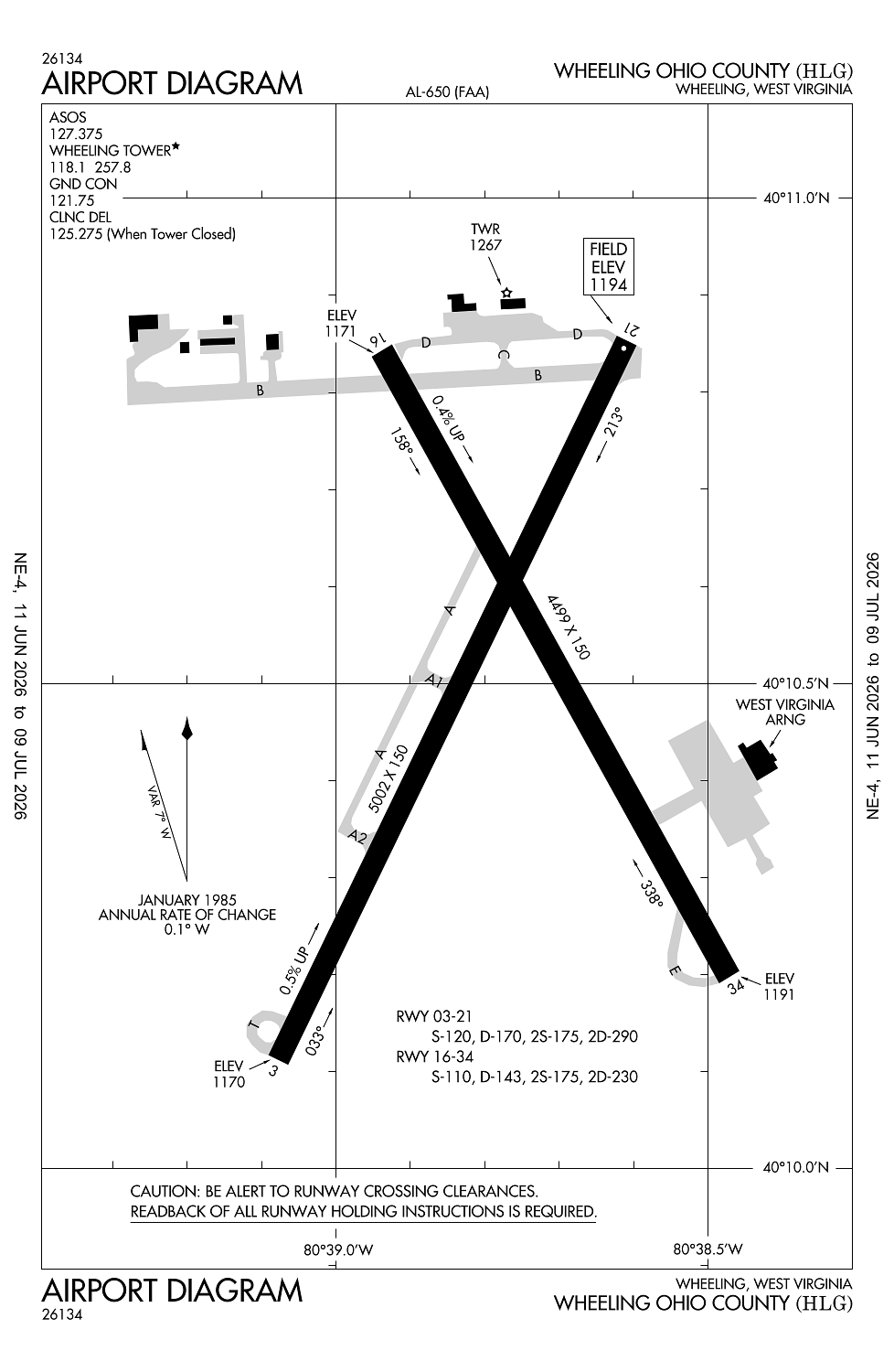
Location:
Wheeling, WV
Elevation:
1,194ft
Sectional:
Cincinnati
Activation date:
Nov 1945
Fuel:
100LL, A+ (prices)
Runway 03/21:
5,002ft
Runway 16/34:
4,499ft
Access: Open to the public
Current Weather — VFR
-
Weather data is strictly informational and not for flight planning purposes.
-
METAR2026-07-20 14:53:00 EDT
Ceiling: Sky clear Wind: Calm Temperature: 78°F Dewpoint: 55°F Weather: N/A Visbility: 10SM Raw:METAR KHLG 201853Z 00000KT 10SM CLR 26/13 A2997 RMK AO2 SLP145 T02610133 -
TAF2026-07-20 14:00:00 EDT – 2026-07-21 07:00:00 EDT
Ceiling: 25,000ft Wind: Variable Weather: N/A Visbility: 6SM Clouds: Broken @ 25,000ft Raw:TAF KHLG 201720Z 2018/2118 VRB04KT P6SM BKN250 FM211100 23010G15KT P6SM SCT090 PROB30 2113/2117 4SM -TSRA OVC020CB FM211700 23010G20KT 6SM -SHRA SCT013 OVC022 -
TAF2026-07-21 07:00:00 EDT – 2026-07-21 13:00:00 EDT
Ceiling: Sky clear Wind: 230° @ 10kt, gusts 15kt Weather: N/A Visbility: 6SM Clouds: Scattered @ 9,000ft Raw:TAF KHLG 201720Z 2018/2118 VRB04KT P6SM BKN250 FM211100 23010G15KT P6SM SCT090 PROB30 2113/2117 4SM -TSRA OVC020CB FM211700 23010G20KT 6SM -SHRA SCT013 OVC022 -
TAF2026-07-21 09:00:00 EDT – 2026-07-21 13:00:00 EDT
Ceiling: 2,000ft Wind: 000° @ kt Weather: Light thunderstorm rain Visbility: 4SM Clouds: Overcast @ 2,000ft Raw:TAF KHLG 201720Z 2018/2118 VRB04KT P6SM BKN250 FM211100 23010G15KT P6SM SCT090 PROB30 2113/2117 4SM -TSRA OVC020CB FM211700 23010G20KT 6SM -SHRA SCT013 OVC022 -
TAF2026-07-21 13:00:00 EDT – 2026-07-21 14:00:00 EDT
Ceiling: 2,200ft Wind: 230° @ 10kt, gusts 20kt Weather: Light rain showers Visbility: 6SM Clouds: Scattered @ 1,300ft, Overcast @ 2,200ft Raw:TAF KHLG 201720Z 2018/2118 VRB04KT P6SM BKN250 FM211100 23010G15KT P6SM SCT090 PROB30 2113/2117 4SM -TSRA OVC020CB FM211700 23010G20KT 6SM -SHRA SCT013 OVC022
Click/tap to add an annotation marker to the map
No webcams added yet.
Remarks
- Paved svc rd extends fm end rwy 03 to faa equip; access controlled.
- Birds and deer on and invof arpt.
- When atct clsd actvt malsf rwy 03; reil rwy 21 & 34; papi rwy 34; hirl rwy 03/21; mirl rwy 16/34; twy lgts excp twy a - ctaf.
- Ctlng obstn exceeds a 45 deg slp.
- Unusbl byd 8 degs left of cntrln.
Comments