Pirep is a free, collaborative database of all public and private airports. All pilots are welcome to contribute their local knowledge to any airport, no registration required.

Undocumented
METAR / TAF
Edit Tags
No upcoming events. Is anything happening here soon?
Airport Statistics
- Tags
- Local flying clubs
- Transient parking location
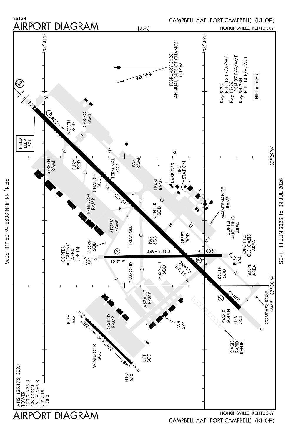
Location:
Fort Campbell/Hopkinsville, KY
Elevation:
571ft
Sectional:
St Louis
Fuel:
A++ (prices)
Runway 05/23:
10,926ft
Runway 18/36:
4,500ft
Access: Private to everyone
This is a military facility.
Current Weather — VFR
-
Weather data is strictly informational and not for flight planning purposes.
-
METAR2026-07-20 16:55:00 CDT
Ceiling: Sky clear Wind: 340° @ 4kt Temperature: 90°F Dewpoint: 77°F Weather: N/A Visbility: 10SM Clouds: Few @ 3,400ft Raw:METAR KHOP 202155Z AUTO 34004KT 10SM FEW034 33/25 A2986 RMK AO2 SLP106 T03250253 -
TAF2026-07-20 11:00:00 CDT – 2026-07-20 19:00:00 CDT
Ceiling: Sky clear Wind: Variable Weather: N/A Visbility: 6SM Clouds: Scattered @ 4,000ft Raw:TAF KHOP 201600Z 2016/2122 VRB06KT 9999 SCT040 QNH2985INS TEMPO 2020/2024 28010G20KT 8000 -TSRA BKN040CB BECMG 2100/2101 VRB06KT 9999 SCT040 QNH2983INS TEMPO 2108/2112 8000 BR BECMG 2112/2113 23009KT 9999 SCT060 QNH2977INS TX32/2021Z TN24/2111Z -
TAF2026-07-20 15:00:00 CDT – 2026-07-20 19:00:00 CDT
Ceiling: 4,000ft Wind: 280° @ 10kt, gusts 20kt Weather: Light thunderstorm rain Visbility: 4SM Clouds: Broken @ 4,000ft Raw:TAF KHOP 201600Z 2016/2122 VRB06KT 9999 SCT040 QNH2985INS TEMPO 2020/2024 28010G20KT 8000 -TSRA BKN040CB BECMG 2100/2101 VRB06KT 9999 SCT040 QNH2983INS TEMPO 2108/2112 8000 BR BECMG 2112/2113 23009KT 9999 SCT060 QNH2977INS TX32/2021Z TN24/2111Z -
TAF2026-07-20 19:00:00 CDT – 2026-07-21 07:00:00 CDT
Ceiling: Sky clear Wind: Variable Weather: N/A Visbility: 6SM Clouds: Scattered @ 4,000ft Raw:TAF KHOP 201600Z 2016/2122 VRB06KT 9999 SCT040 QNH2985INS TEMPO 2020/2024 28010G20KT 8000 -TSRA BKN040CB BECMG 2100/2101 VRB06KT 9999 SCT040 QNH2983INS TEMPO 2108/2112 8000 BR BECMG 2112/2113 23009KT 9999 SCT060 QNH2977INS TX32/2021Z TN24/2111Z -
TAF2026-07-21 03:00:00 CDT – 2026-07-21 07:00:00 CDT
Ceiling: Sky clear Wind: 000° @ kt Weather: Mist Visbility: 4SM Raw:TAF KHOP 201600Z 2016/2122 VRB06KT 9999 SCT040 QNH2985INS TEMPO 2020/2024 28010G20KT 8000 -TSRA BKN040CB BECMG 2100/2101 VRB06KT 9999 SCT040 QNH2983INS TEMPO 2108/2112 8000 BR BECMG 2112/2113 23009KT 9999 SCT060 QNH2977INS TX32/2021Z TN24/2111Z -
TAF2026-07-21 07:00:00 CDT – 2026-07-21 17:00:00 CDT
Ceiling: Sky clear Wind: 230° @ 9kt Weather: N/A Visbility: 6SM Clouds: Scattered @ 6,000ft Raw:TAF KHOP 201600Z 2016/2122 VRB06KT 9999 SCT040 QNH2985INS TEMPO 2020/2024 28010G20KT 8000 -TSRA BKN040CB BECMG 2100/2101 VRB06KT 9999 SCT040 QNH2983INS TEMPO 2108/2112 8000 BR BECMG 2112/2113 23009KT 9999 SCT060 QNH2977INS TX32/2021Z TN24/2111Z
Click/tap to add an annotation marker to the map
No webcams added yet.
Remarks
- Cstms/ag/img: avbl 72 hr ppr; mil acft only - d635-7146.
- Oil: o-123-128-148-156 sp
- Fleet svc not avbl.
- Ctn: pje; r3701 & small arms range 1000 yd fm dep end rwy 23; deer haz.
- Base ops h24 - dsn 635-7146/7147/c270-798-7146/47.
Comments