Pirep is a free, collaborative database of all public and private airports. All pilots are welcome to contribute their local knowledge to any airport, no registration required.


Public
Undocumented
METAR / TAF
Edit Tags
No upcoming events. Is anything happening here soon?
Airport Statistics
- General description
- Tags
- Transient parking location
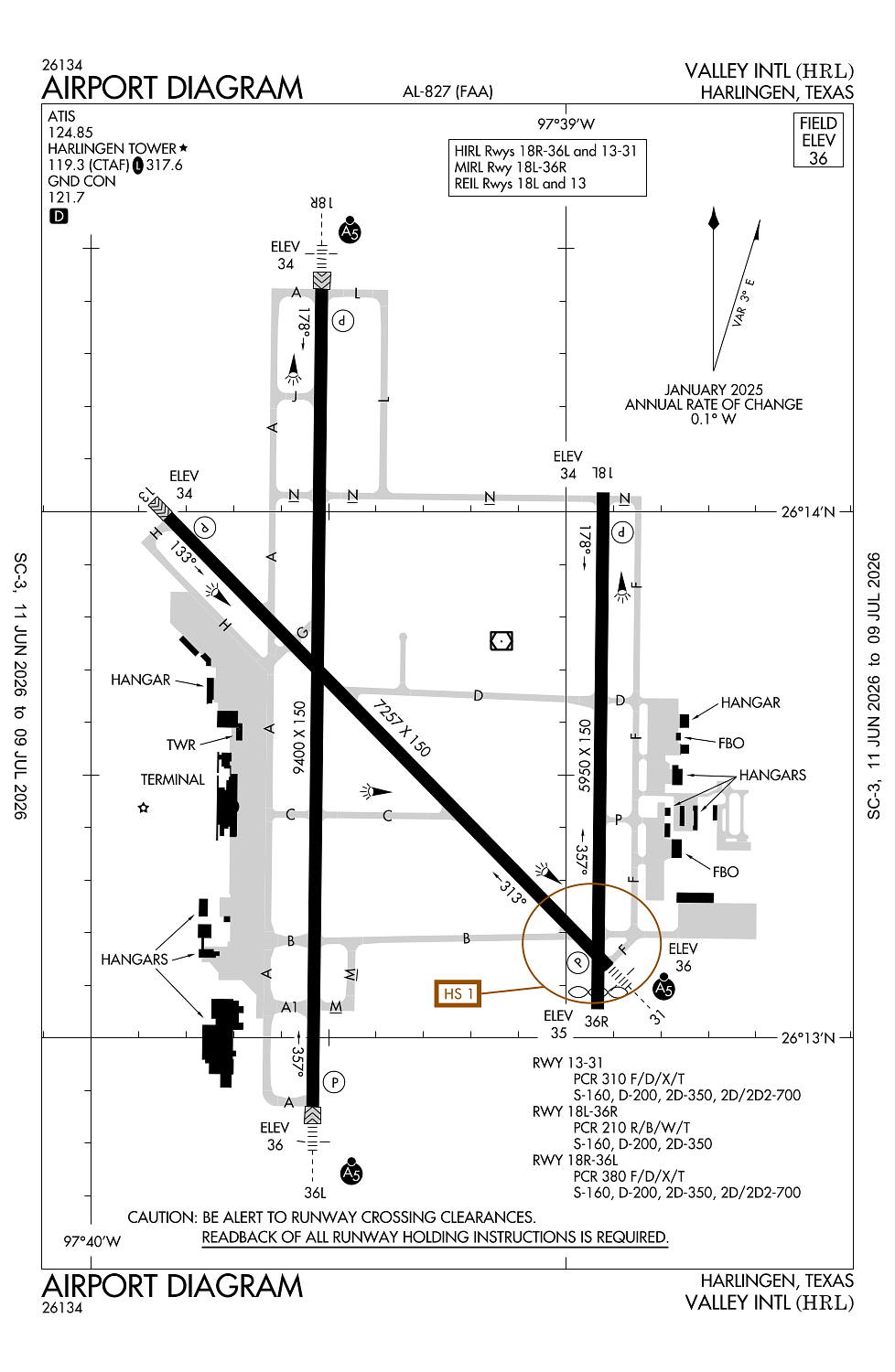
Location:
Harlingen, TX
Elevation:
36ft
Sectional:
Brownsville
Activation date:
Jul 1943
Fuel:
100LL, A (prices)
Runway 18R/36L:
9,400ft
Runway 17R/35L:
8,301ft
Runway 13/31:
7,257ft
Runway 18L/36R:
5,950ft
Runway 17L/35R:
5,949ft
Access: Open to the public
Current Weather — VFR
-
Weather data is strictly informational and not for flight planning purposes.
-
METAR2026-07-20 20:52:00 CDT
Ceiling: Sky clear Wind: 130° @ 14kt Temperature: 84°F Dewpoint: 75°F Weather: N/A Visbility: 10SM Raw:METAR KHRL 210152Z 13014KT 10SM CLR 29/24 A2988 RMK AO2 SLP116 T02890239 -
TAF2026-07-20 19:00:00 CDT – 2026-07-20 20:00:00 CDT
Ceiling: Sky clear Wind: 160° @ 17kt, gusts 25kt Weather: N/A Visbility: 6SM Clouds: @ ft Raw:TAF KHRL 202337Z 2100/2124 16017G25KT P6SM SKC FM210100 15010G20KT P6SM FEW250 FM210300 16006KT P6SM FEW250 FM212200 15013G23KT P6SM FEW250 -
TAF2026-07-20 20:00:00 CDT – 2026-07-20 22:00:00 CDT
Ceiling: Sky clear Wind: 150° @ 10kt, gusts 20kt Weather: N/A Visbility: 6SM Clouds: Few @ 25,000ft Raw:TAF KHRL 202337Z 2100/2124 16017G25KT P6SM SKC FM210100 15010G20KT P6SM FEW250 FM210300 16006KT P6SM FEW250 FM212200 15013G23KT P6SM FEW250 -
TAF2026-07-20 22:00:00 CDT – 2026-07-21 17:00:00 CDT
Ceiling: Sky clear Wind: 160° @ 6kt Weather: N/A Visbility: 6SM Clouds: Few @ 25,000ft Raw:TAF KHRL 202337Z 2100/2124 16017G25KT P6SM SKC FM210100 15010G20KT P6SM FEW250 FM210300 16006KT P6SM FEW250 FM212200 15013G23KT P6SM FEW250 -
TAF2026-07-21 17:00:00 CDT – 2026-07-21 19:00:00 CDT
Ceiling: Sky clear Wind: 150° @ 13kt, gusts 23kt Weather: N/A Visbility: 6SM Clouds: Few @ 25,000ft Raw:TAF KHRL 202337Z 2100/2124 16017G25KT P6SM SKC FM210100 15010G20KT P6SM FEW250 FM210300 16006KT P6SM FEW250 FM212200 15013G23KT P6SM FEW250
Click/tap to add an annotation marker to the map
No webcams added yet.
Remarks
- Migratory birds on & invof arpt.
- When atct clsd req arff thru corpus approach or flt svc.
- For cd when atct is clsd ctc crp apch at 361-299-4230.
- Dusk-dawn. when atct clsd actvt malsr rwy 18r, rwy 31, rwy 36l - ctaf.
- Pcr value: 310/f/d/x/t
Comments