HUA - Redstone Aaf

Pirep is a free, collaborative database of all public and private airports. All pilots are welcome to contribute their local knowledge to any airport, no registration required.
Uploaded photos will be licensed under a CC BY-SA 4.0 license. Please only upload photos you have the rights to use.
Tags
Undocu­mented
METAR / TAF
Edit Tags
Food
Camping
Lodging
Car Rental
Bicycles
Swimming
Golfing
Fishing
Hot Springs
Museum
Flying Clubs
Airpark
Upcoming Events
No upcoming events. Is anything happening here soon?
*
*
*

Where exactly on/near the airport is this event taking place?

Is there a webpage with more information for this event?

Who should be contacted for more information?

What is this event all about?

Repeat every
Description
Transient Parking
Fuel Location
Landing & Tie-down Fees
Crew Car Availability
Flying Clubs
WiFi Access
Airport Statistics
0%
Are you familiar with this airport? Help complete its documentation by adding some of the following info if applicable:
  • Tags
  • Airport map annotations
  • Webcam links
Location: 
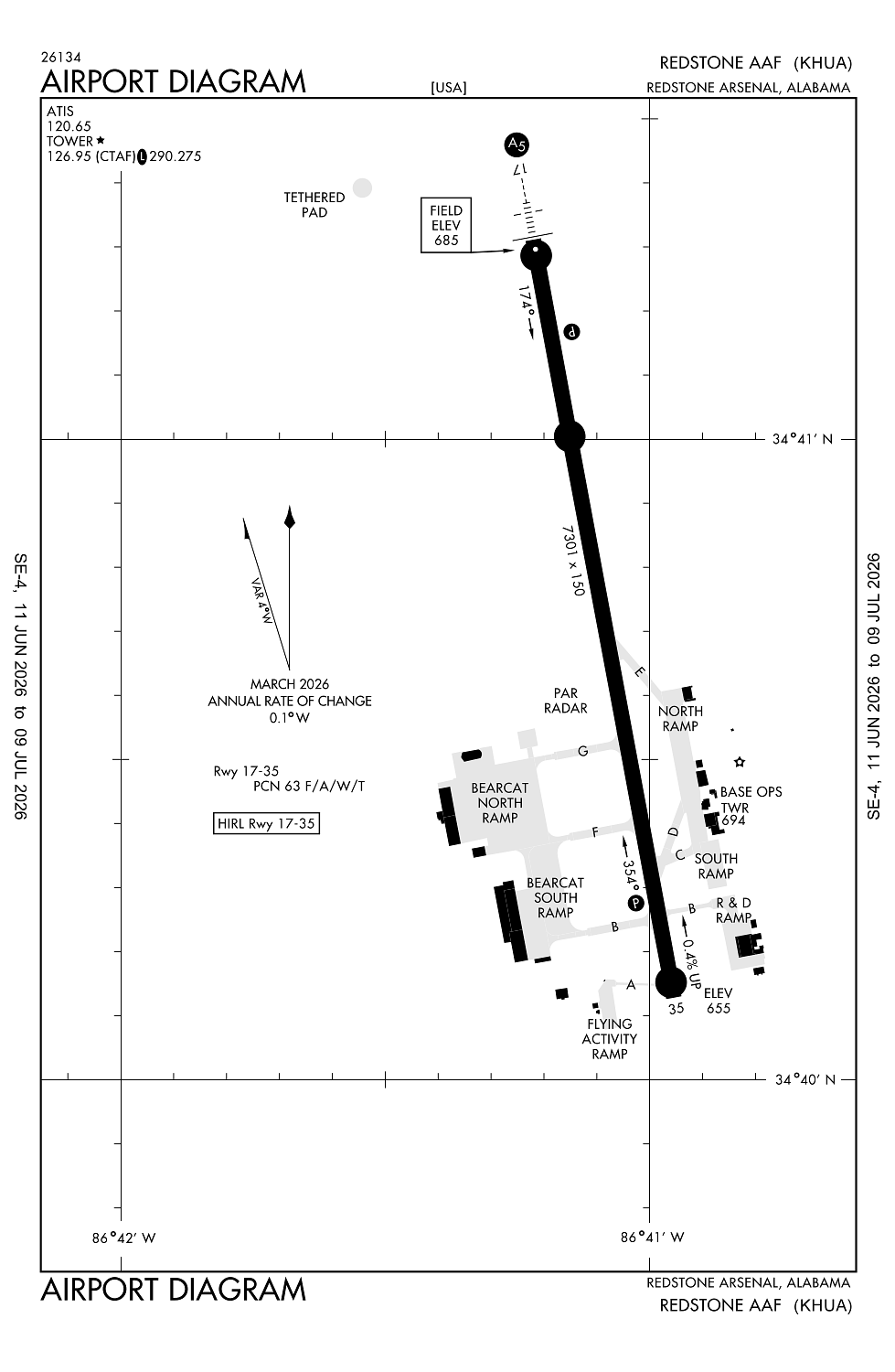
Redstone Arsnl Huntsville, AL
Elevation: 685ft
Sectional: Atlanta
Fuel: 100LL (prices)
Runway 17/35: 7,300ft
Access: Private to everyone
This is a military facility.
Current Weather — VFR
  • Weather data is strictly informational and not for flight planning purposes.
  • METAR
    2026-03-17 12:53:00 CDT
    Ceiling: Sky clear
    Wind: 300° @ 12kt
    Temperature: 35°F
    Dewpoint: 8°F
    Weather: N/A
    Visbility: 7SM
    Raw: METAR KHUA 171753Z 30012KT 7SM CLR 02/M13 A3025 RMK SLPNO RVRNO $
  • TAF
    2026-03-16 07:00:00 CDT – 2026-03-16 12:00:00 CDT
    Ceiling: 2,000ft
    Wind: 000° @ kt
    Weather: Light snow
    Visbility: 4SM
    Clouds: Overcast @ 2,000ft
    Raw: TAF KHUA 161200Z 1612/1718 29015G25KT 9999 OVC025 QNH2982INS TEMPO 1612/1617 8000 -SN OVC020 620409 BECMG 1620/1621 30015G25KT 9999 BKN080 QNH2993INS BECMG 1701/1702 31010KT 9999 OVC050 QNH3005INS TX04/1619Z TN01/1701Z
  • TAF
    2026-03-16 07:00:00 CDT – 2026-03-16 15:00:00 CDT
    Ceiling: 2,500ft
    Wind: 290° @ 15kt, gusts 25kt
    Weather: N/A
    Visbility: 6SM
    Clouds: Overcast @ 2,500ft
    Raw: TAF KHUA 161200Z 1612/1718 29015G25KT 9999 OVC025 QNH2982INS TEMPO 1612/1617 8000 -SN OVC020 620409 BECMG 1620/1621 30015G25KT 9999 BKN080 QNH2993INS BECMG 1701/1702 31010KT 9999 OVC050 QNH3005INS TX04/1619Z TN01/1701Z
  • TAF
    2026-03-16 15:00:00 CDT – 2026-03-16 20:00:00 CDT
    Ceiling: 8,000ft
    Wind: 300° @ 15kt, gusts 25kt
    Weather: N/A
    Visbility: 6SM
    Clouds: Broken @ 8,000ft
    Raw: TAF KHUA 161200Z 1612/1718 29015G25KT 9999 OVC025 QNH2982INS TEMPO 1612/1617 8000 -SN OVC020 620409 BECMG 1620/1621 30015G25KT 9999 BKN080 QNH2993INS BECMG 1701/1702 31010KT 9999 OVC050 QNH3005INS TX04/1619Z TN01/1701Z
  • TAF
    2026-03-16 20:00:00 CDT – 2026-03-17 13:00:00 CDT
    Ceiling: 5,000ft
    Wind: 310° @ 10kt
    Weather: N/A
    Visbility: 6SM
    Clouds: Overcast @ 5,000ft
    Raw: TAF KHUA 161200Z 1612/1718 29015G25KT 9999 OVC025 QNH2982INS TEMPO 1612/1617 8000 -SN OVC020 620409 BECMG 1620/1621 30015G25KT 9999 BKN080 QNH2993INS BECMG 1701/1702 31010KT 9999 OVC050 QNH3005INS TX04/1619Z TN01/1701Z
Click/tap to add an annotation marker to the map
Airport Webcams
No webcams added yet.
Direct links to live image URLs will be displayed inline on this page. URLs to separate webpages will be linked to.
URL:
Direct links to live image URLs will be displayed inline on this page. URLs to separate webpages will be linked to.
URL:
Remarks
  • Fuel: a ++ (avbl 1230-0330z++ mon-fri exc hol; ot o/r).
  • Tran alert: ltd svc.
  • Rstd: 24 hr ppr all acft, 48 hr ppr acft with haz cargo. ctc base ops dsn 746-7916/4299 c256-876-1916/4299. reful exp delay. acft must adhere to ppr arr block time +/- 30 min of sked ldg.
  • Misc: ltd prk. no photography allowed wo base ops apvl.
  • Caution: deer, tukey, coyote haz. acft larger than c-12 use extreme caution while taxiing due to min wg tip clnc.
Comments
Leave a comment What was your experience like at this airport?