Pirep is a free, collaborative database of all public and private airports. All pilots are welcome to contribute their local knowledge to any airport, no registration required.
Undocumented
METAR / TAF
Edit Tags
No upcoming events. Is anything happening here soon?
Airport Statistics
- Airport photos
- Crew car availability
- Transient parking location
Location:
Wichita, KS
Elevation:
1,371ft
Sectional:
Wichita
Activation date:
Apr 1940
Fuel:
None
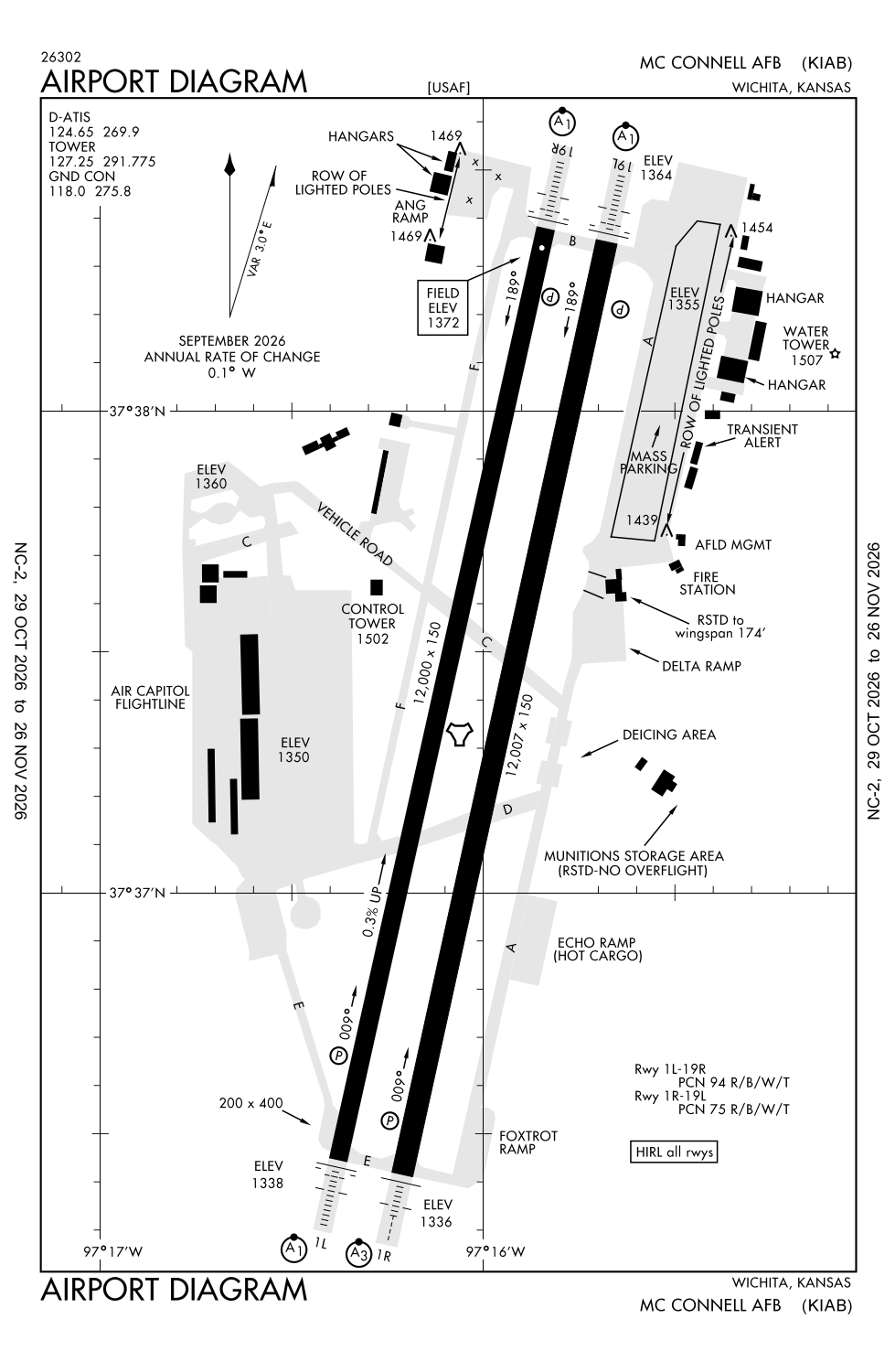
Runway 01R/19L:
12,007ft
Runway 01L/19R:
12,000ft
Access: Private to everyone
This is a military facility.
Current Weather — VFR
-
Weather data is strictly informational and not for flight planning purposes.
-
METAR2026-11-14 12:55:00 CST
Ceiling: Sky clear Wind: 160° @ 11kt Temperature: 51°F Dewpoint: 29°F Weather: N/A Visbility: 10SM Raw:METAR KIAB 141855Z AUTO 16011KT 10SM CLR 11/M01 A3014 RMK AO2 SLP214 T01111013 $ -
TAF2026-11-14 12:00:00 CST – 2026-11-14 23:00:00 CST
Ceiling: 5,000ft Wind: 130° @ 12kt Weather: N/A Visbility: 6SM Clouds: Broken @ 5,000ft, Overcast @ 7,000ft Raw:TAF KIAB 141800Z 1418/1524 13012KT 9999 BKN050 OVC070 QNH3013INS BECMG 1505/1506 13012KT 9999 VCSH BKN025 OVC050 QNH3022INS TEMPO 1512/1516 8000 -SHRA BKN007 BECMG 1515/1516 15009KT 9999 NSW BKN012 OVC030 QNH3035INS TX11/1421Z TN04/1512Z -
TAF2026-11-14 23:00:00 CST – 2026-11-15 09:00:00 CST
Ceiling: 2,500ft Wind: 130° @ 12kt Weather: Showers in vicinity Visbility: 6SM Clouds: Broken @ 2,500ft, Overcast @ 5,000ft Raw:TAF KIAB 141800Z 1418/1524 13012KT 9999 BKN050 OVC070 QNH3013INS BECMG 1505/1506 13012KT 9999 VCSH BKN025 OVC050 QNH3022INS TEMPO 1512/1516 8000 -SHRA BKN007 BECMG 1515/1516 15009KT 9999 NSW BKN012 OVC030 QNH3035INS TX11/1421Z TN04/1512Z -
TAF2026-11-15 06:00:00 CST – 2026-11-15 10:00:00 CST
Ceiling: 700ft Wind: 000° @ kt Weather: Light rain showers Visbility: 4SM Clouds: Broken @ 700ft Raw:TAF KIAB 141800Z 1418/1524 13012KT 9999 BKN050 OVC070 QNH3013INS BECMG 1505/1506 13012KT 9999 VCSH BKN025 OVC050 QNH3022INS TEMPO 1512/1516 8000 -SHRA BKN007 BECMG 1515/1516 15009KT 9999 NSW BKN012 OVC030 QNH3035INS TX11/1421Z TN04/1512Z -
TAF2026-11-15 09:00:00 CST – 2026-11-15 18:00:00 CST
Ceiling: 1,200ft Wind: 150° @ 9kt Weather: N/A Visbility: 6SM Clouds: Broken @ 1,200ft, Overcast @ 3,000ft Raw:TAF KIAB 141800Z 1418/1524 13012KT 9999 BKN050 OVC070 QNH3013INS BECMG 1505/1506 13012KT 9999 VCSH BKN025 OVC050 QNH3022INS TEMPO 1512/1516 8000 -SHRA BKN007 BECMG 1515/1516 15009KT 9999 NSW BKN012 OVC030 QNH3035INS TX11/1421Z TN04/1512Z
Click/tap to add an annotation marker to the map
No webcams added yet.
Remarks
- Ppr v962-5271.
- Jasu: 4(m32a-86) (ma-1a) (mc-1a) 2(mc-2a) 5(md-4) 3(am32-95)
- Fuel: a++
- Oil: o-133-148-156 soap.
- Tran alert: no priority basis. ltd tran maint svc avbl 1300-0500z++ wkd; 1400-0000z++ sat-sun; clsd fed hol.
Comments