Pirep is a free, collaborative database of all public and private airports. All pilots are welcome to contribute their local knowledge to any airport, no registration required.


Public
Undocumented
METAR / TAF
Edit Tags
No upcoming events. Is anything happening here soon?
Airport Statistics
- Crew car availability
- Airport map annotations
- Tags
Location:
New York, NY
Elevation:
98ft
Sectional:
New York
Activation date:
May 1943
Fuel:
100LL, A (prices)
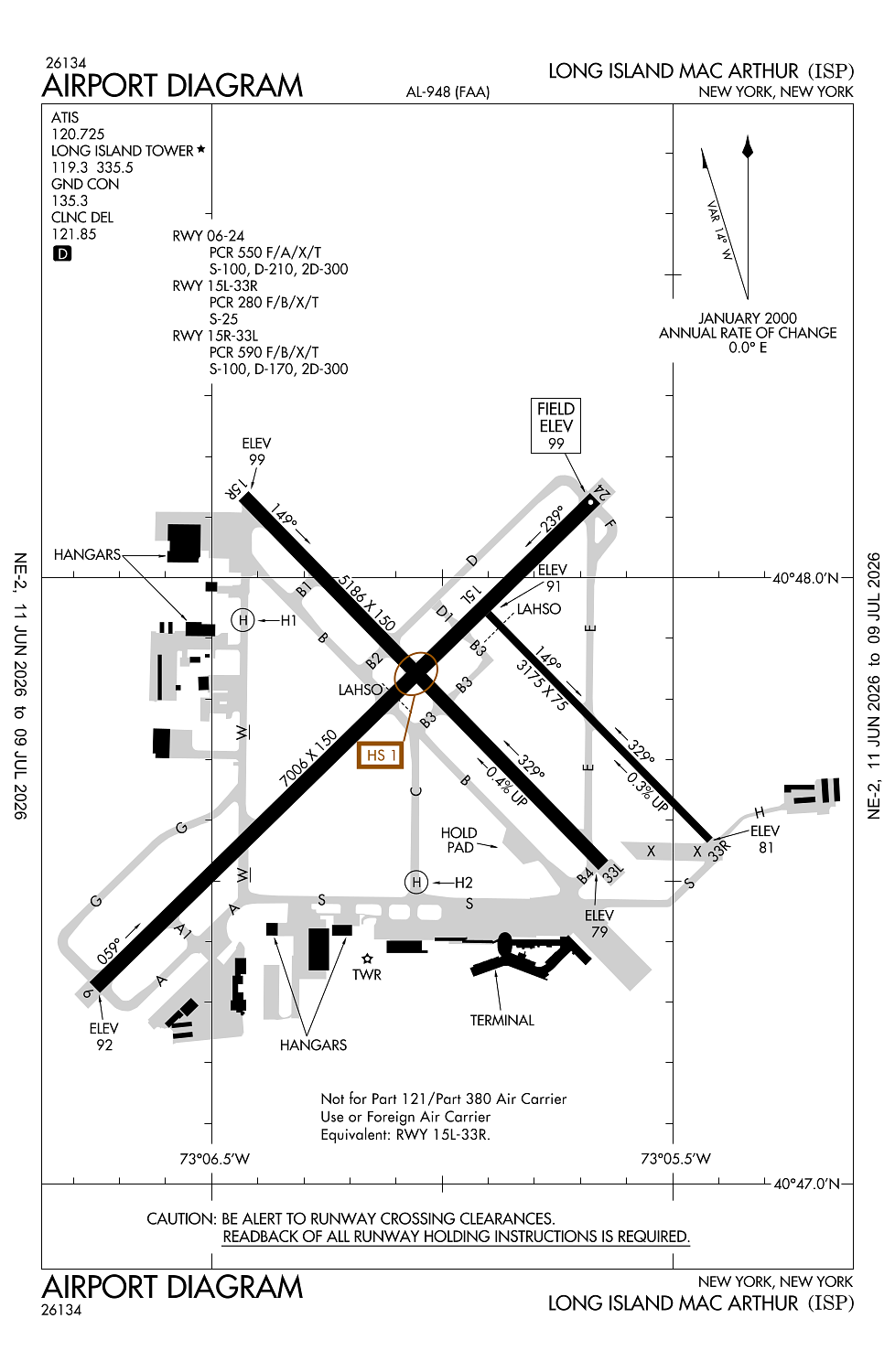
Runway 06/24:
7,006ft
Runway 15R/33L:
5,186ft
Runway 15L/33R:
3,175ft
Runway H1:
50ft
Runway H2:
50ft
Access: Open to the public
Current Weather — VFR
-
Weather data is strictly informational and not for flight planning purposes.
-
METAR2026-07-16 04:56:00 EDT
Ceiling: 6,000ft Wind: 300° @ 5kt Temperature: 73°F Dewpoint: 59°F Weather: N/A Visbility: 10SM Clouds: Overcast @ 6,000ft Raw:METAR KISP 160856Z AUTO 30005KT 10SM OVC060 23/15 A2991 RMK AO2 SLP128 T02330150 53004 -
TAF2026-07-16 05:00:00 EDT – 2026-07-16 08:00:00 EDT
Ceiling: 5,000ft Wind: Variable Weather: N/A Visbility: 6SM Clouds: Broken @ 5,000ft, Broken @ 25,000ft Raw:TAF KISP 160831Z 1609/1706 VRB05KT P6SM BKN050 BKN250 FM161200 29006KT 6SM HZ SCT050 BKN250 FM161600 25010KT 5SM FU SCT050 BKN250 FM161800 24012G20KT 5SM FU SCT050 BKN250 TEMPO 1619/1623 3SM FU FM162300 29011KT 4SM FU FEW050 BKN250 FM170300 30006KT 5SM FU BKN250 -
TAF2026-07-16 08:00:00 EDT – 2026-07-16 12:00:00 EDT
Ceiling: 25,000ft Wind: 290° @ 6kt Weather: Haze Visbility: 6SM Clouds: Scattered @ 5,000ft, Broken @ 25,000ft Raw:TAF KISP 160831Z 1609/1706 VRB05KT P6SM BKN050 BKN250 FM161200 29006KT 6SM HZ SCT050 BKN250 FM161600 25010KT 5SM FU SCT050 BKN250 FM161800 24012G20KT 5SM FU SCT050 BKN250 TEMPO 1619/1623 3SM FU FM162300 29011KT 4SM FU FEW050 BKN250 FM170300 30006KT 5SM FU BKN250 -
TAF2026-07-16 12:00:00 EDT – 2026-07-16 14:00:00 EDT
Ceiling: 25,000ft Wind: 250° @ 10kt Weather: Smoke Visbility: 5SM Clouds: Scattered @ 5,000ft, Broken @ 25,000ft Raw:TAF KISP 160831Z 1609/1706 VRB05KT P6SM BKN050 BKN250 FM161200 29006KT 6SM HZ SCT050 BKN250 FM161600 25010KT 5SM FU SCT050 BKN250 FM161800 24012G20KT 5SM FU SCT050 BKN250 TEMPO 1619/1623 3SM FU FM162300 29011KT 4SM FU FEW050 BKN250 FM170300 30006KT 5SM FU BKN250 -
TAF2026-07-16 14:00:00 EDT – 2026-07-16 19:00:00 EDT
Ceiling: 25,000ft Wind: 240° @ 12kt, gusts 20kt Weather: Smoke Visbility: 5SM Clouds: Scattered @ 5,000ft, Broken @ 25,000ft Raw:TAF KISP 160831Z 1609/1706 VRB05KT P6SM BKN050 BKN250 FM161200 29006KT 6SM HZ SCT050 BKN250 FM161600 25010KT 5SM FU SCT050 BKN250 FM161800 24012G20KT 5SM FU SCT050 BKN250 TEMPO 1619/1623 3SM FU FM162300 29011KT 4SM FU FEW050 BKN250 FM170300 30006KT 5SM FU BKN250 -
TAF2026-07-16 15:00:00 EDT – 2026-07-16 19:00:00 EDT
Ceiling: Sky clear Wind: 000° @ kt Weather: Smoke Visbility: 3SM Raw:TAF KISP 160831Z 1609/1706 VRB05KT P6SM BKN050 BKN250 FM161200 29006KT 6SM HZ SCT050 BKN250 FM161600 25010KT 5SM FU SCT050 BKN250 FM161800 24012G20KT 5SM FU SCT050 BKN250 TEMPO 1619/1623 3SM FU FM162300 29011KT 4SM FU FEW050 BKN250 FM170300 30006KT 5SM FU BKN250 -
TAF2026-07-16 19:00:00 EDT – 2026-07-16 23:00:00 EDT
Ceiling: 25,000ft Wind: 290° @ 11kt Weather: Smoke Visbility: 4SM Clouds: Few @ 5,000ft, Broken @ 25,000ft Raw:TAF KISP 160831Z 1609/1706 VRB05KT P6SM BKN050 BKN250 FM161200 29006KT 6SM HZ SCT050 BKN250 FM161600 25010KT 5SM FU SCT050 BKN250 FM161800 24012G20KT 5SM FU SCT050 BKN250 TEMPO 1619/1623 3SM FU FM162300 29011KT 4SM FU FEW050 BKN250 FM170300 30006KT 5SM FU BKN250 -
TAF2026-07-16 23:00:00 EDT – 2026-07-17 02:00:00 EDT
Ceiling: 25,000ft Wind: 300° @ 6kt Weather: Smoke Visbility: 5SM Clouds: Broken @ 25,000ft Raw:TAF KISP 160831Z 1609/1706 VRB05KT P6SM BKN050 BKN250 FM161200 29006KT 6SM HZ SCT050 BKN250 FM161600 25010KT 5SM FU SCT050 BKN250 FM161800 24012G20KT 5SM FU SCT050 BKN250 TEMPO 1619/1623 3SM FU FM162300 29011KT 4SM FU FEW050 BKN250 FM170300 30006KT 5SM FU BKN250
Click/tap to add an annotation marker to the map
No webcams added yet.
Remarks
- Adzy:tfc lndg rwy 33l high density vfr tfc operg 600 ft msl & blw vcnty bayport aerodrome 3 miles se.
- Bird actvty on & invof arpt.
- Twy s unlgtd east of trml apn.
- Rwy 15l/33r clsd to fixed wing acft at ngt & avbl for txg.
- Updrafts may be encountered invof power plant 1.5 nm ne rwy 24.
Comments