Pirep is a free, collaborative database of all public and private airports. All pilots are welcome to contribute their local knowledge to any airport, no registration required.
Undocumented
METAR / TAF
Edit Tags
No upcoming events. Is anything happening here soon?
Airport Statistics
- Local flying clubs
- Airport photos
- Transient parking location
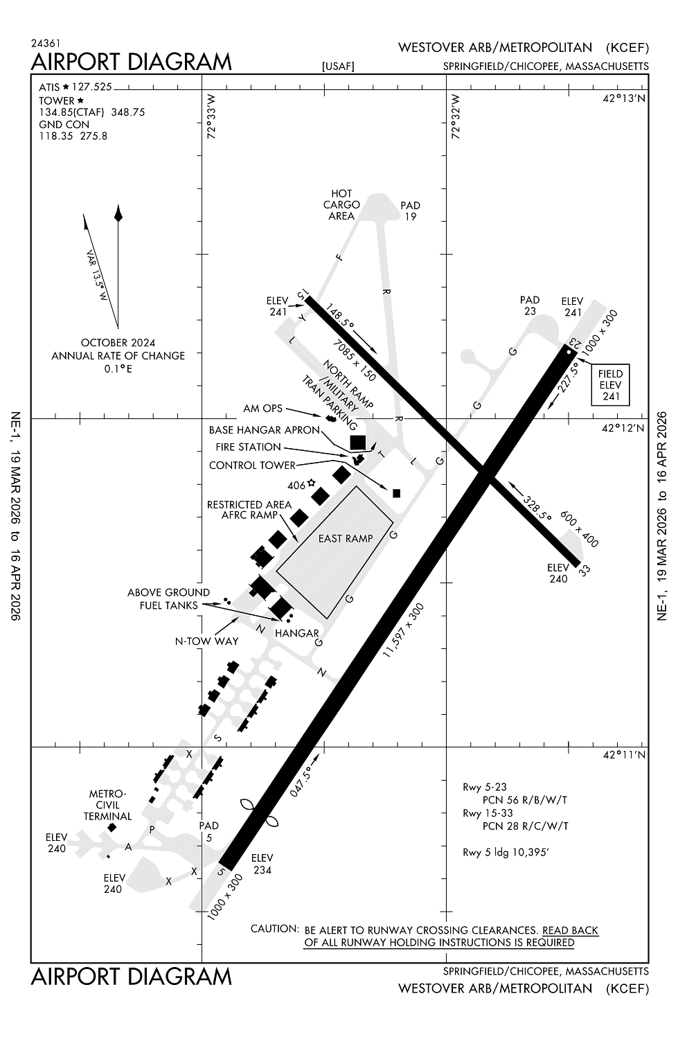
Location:
Springfield/Chicopee, MA
Elevation:
241ft
Sectional:
New York
Activation date:
Jul 1942
Fuel:
100LL, A (prices)
Runway 05/23:
11,597ft
Runway 15/33:
7,085ft
Access: Open to the public
Current Weather — VFR
-
Weather data is strictly informational and not for flight planning purposes.
-
METAR2026-03-21 17:55:00 EDT
Ceiling: Sky clear Wind: 020° @ 12kt Temperature: 45°F Dewpoint: 19°F Weather: N/A Visbility: 10SM Raw:METAR KCEF 212155Z AUTO 02012KT 10SM CLR 08/M07 A2993 RMK AO2 SLP140 T00761069 -
TAF2026-03-21 13:00:00 EDT – 2026-03-21 18:00:00 EDT
Ceiling: Sky clear Wind: 340° @ 12kt, gusts 20kt Weather: N/A Visbility: 6SM Clouds: Scattered @ 4,000ft Raw:TAF KCEF 211700Z 2117/2223 34012G20KT 9999 SCT040 QNH2983INS BECMG 2122/2123 36009KT 9999 FEW040 BKN200 QNH2989INS WND VRB06KT AFT 2203 BECMG 2207/2208 VRB06KT 8000 -SHRA BR FEW006 BKN015 OVC040 620158 QNH2992INS BECMG 2212/2213 18009KT 8000 -RA BR FEW006 OVC015 QNH2969INS TEMPO 2216/2223 16012G18KT 4000 -RA BR BKN006 OVC015 TX12/2119Z TN02/2209Z LAST NO AMDS AFT 2121 NEXT 2217 -
TAF2026-03-21 18:00:00 EDT – 2026-03-22 03:00:00 EDT
Ceiling: 20,000ft Wind: 360° @ 9kt Weather: N/A Visbility: 6SM Clouds: Few @ 4,000ft, Broken @ 20,000ft Raw:TAF KCEF 211700Z 2117/2223 34012G20KT 9999 SCT040 QNH2983INS BECMG 2122/2123 36009KT 9999 FEW040 BKN200 QNH2989INS WND VRB06KT AFT 2203 BECMG 2207/2208 VRB06KT 8000 -SHRA BR FEW006 BKN015 OVC040 620158 QNH2992INS BECMG 2212/2213 18009KT 8000 -RA BR FEW006 OVC015 QNH2969INS TEMPO 2216/2223 16012G18KT 4000 -RA BR BKN006 OVC015 TX12/2119Z TN02/2209Z LAST NO AMDS AFT 2121 NEXT 2217 -
TAF2026-03-22 03:00:00 EDT – 2026-03-22 08:00:00 EDT
Ceiling: 1,500ft Wind: Variable Weather: Light rain showers, mist Visbility: 4SM Clouds: Few @ 600ft, Broken @ 1,500ft, Overcast @ 4,000ft Raw:TAF KCEF 211700Z 2117/2223 34012G20KT 9999 SCT040 QNH2983INS BECMG 2122/2123 36009KT 9999 FEW040 BKN200 QNH2989INS WND VRB06KT AFT 2203 BECMG 2207/2208 VRB06KT 8000 -SHRA BR FEW006 BKN015 OVC040 620158 QNH2992INS BECMG 2212/2213 18009KT 8000 -RA BR FEW006 OVC015 QNH2969INS TEMPO 2216/2223 16012G18KT 4000 -RA BR BKN006 OVC015 TX12/2119Z TN02/2209Z LAST NO AMDS AFT 2121 NEXT 2217 -
TAF2026-03-22 08:00:00 EDT – 2026-03-22 19:00:00 EDT
Ceiling: 1,500ft Wind: 180° @ 9kt Weather: Light rain, mist Visbility: 4SM Clouds: Few @ 600ft, Overcast @ 1,500ft Raw:TAF KCEF 211700Z 2117/2223 34012G20KT 9999 SCT040 QNH2983INS BECMG 2122/2123 36009KT 9999 FEW040 BKN200 QNH2989INS WND VRB06KT AFT 2203 BECMG 2207/2208 VRB06KT 8000 -SHRA BR FEW006 BKN015 OVC040 620158 QNH2992INS BECMG 2212/2213 18009KT 8000 -RA BR FEW006 OVC015 QNH2969INS TEMPO 2216/2223 16012G18KT 4000 -RA BR BKN006 OVC015 TX12/2119Z TN02/2209Z LAST NO AMDS AFT 2121 NEXT 2217 -
TAF2026-03-22 12:00:00 EDT – 2026-03-22 19:00:00 EDT
Ceiling: 600ft Wind: 160° @ 12kt, gusts 18kt Weather: Light rain, mist Visbility: 2SM Clouds: Broken @ 600ft, Overcast @ 1,500ft Raw:TAF KCEF 211700Z 2117/2223 34012G20KT 9999 SCT040 QNH2983INS BECMG 2122/2123 36009KT 9999 FEW040 BKN200 QNH2989INS WND VRB06KT AFT 2203 BECMG 2207/2208 VRB06KT 8000 -SHRA BR FEW006 BKN015 OVC040 620158 QNH2992INS BECMG 2212/2213 18009KT 8000 -RA BR FEW006 OVC015 QNH2969INS TEMPO 2216/2223 16012G18KT 4000 -RA BR BKN006 OVC015 TX12/2119Z TN02/2209Z LAST NO AMDS AFT 2121 NEXT 2217
Click/tap to add an annotation marker to the map
No webcams added yet.
Remarks
- Clear side is split. dalgt turned on when airfield is ifr.
- Dusk-2300. airfield lgts not avbl 2300-0700 hrs.
- Civ trng ltd to low apch only; tgl not auth.
- Cef is a joint-use afld. ifr tkof & ldg min as prescribed by usaf reg apply.
- Hvy vfr tfc below 10,000 ft along river & hwy 5 nm sw of afld.
Comments