Pirep is a free, collaborative database of all public and private airports. All pilots are welcome to contribute their local knowledge to any airport, no registration required.


Public
Undocumented
METAR / TAF
Edit Tags
No upcoming events. Is anything happening here soon?
Airport Statistics
- Airport map annotations
- Crew car availability
- Local flying clubs
Location:
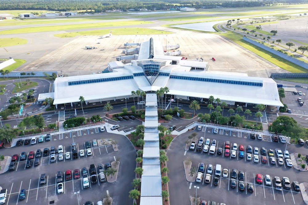
Daytona Beach, FL
Elevation:
34ft
Sectional:
Jacksonville
Activation date:
Apr 1940
Fuel:
100LL, A (prices)
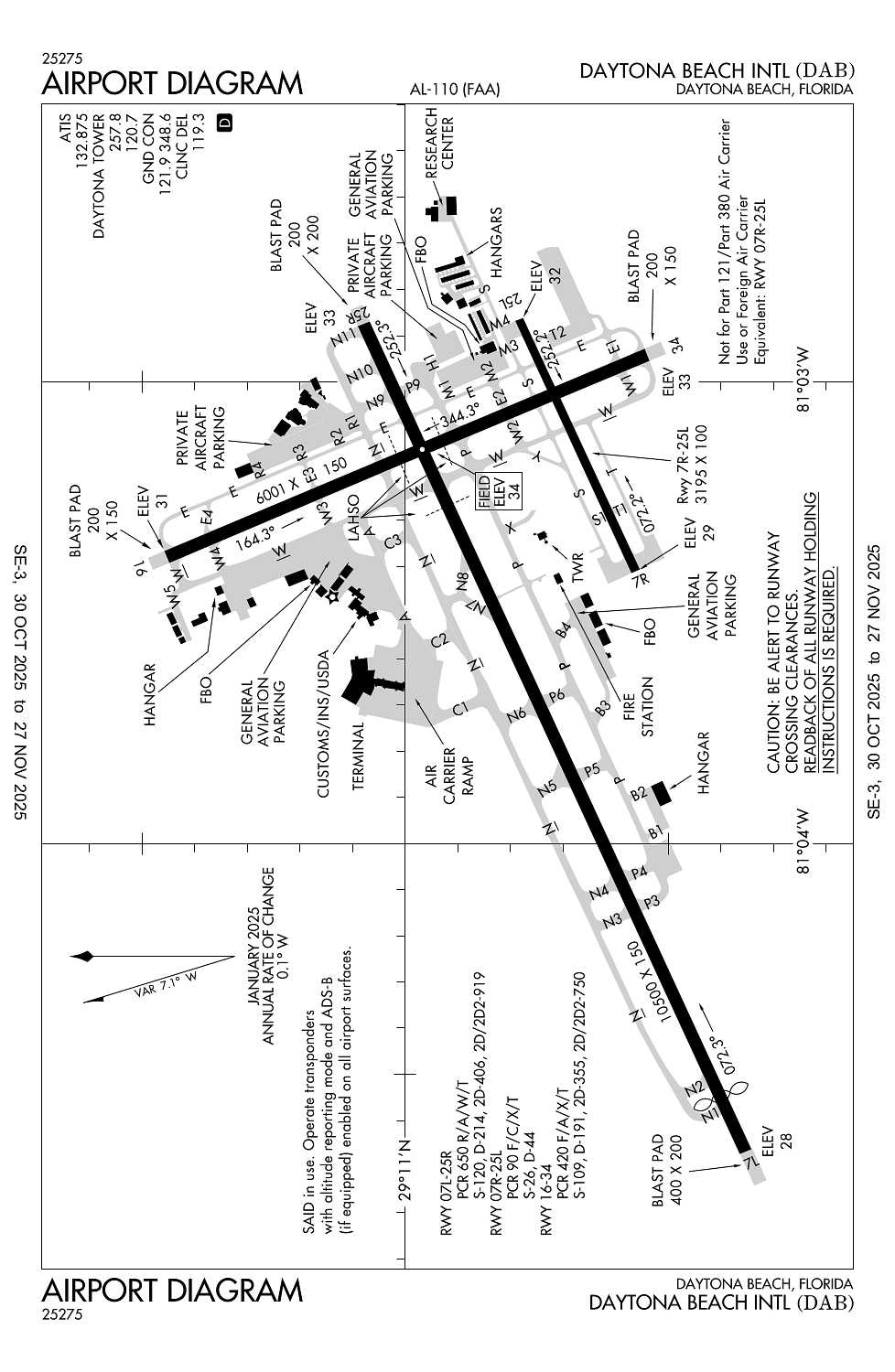
Runway 07L/25R:
10,500ft
Runway 16/34:
6,001ft
Runway 07R/25L:
3,195ft
Access: Open to the public
Current Weather — VFR
-
Weather data is strictly informational and not for flight planning purposes.
-
METAR2025-12-14 05:53:00 EST
Ceiling: Sky clear Wind: Calm Temperature: 55°F Dewpoint: 55°F Weather: N/A Visbility: 10SM Raw:METAR KDAB 141053Z 00000KT 10SM CLR 13/13 A3006 RMK AO2 SLP178 T01280128 -
TAF2025-12-14 04:00:00 EST – 2025-12-14 09:00:00 EST
Ceiling: Sky clear Wind: 270° @ 2kt Weather: Shallow fog Visbility: 6SM Clouds: Few @ 5,000ft, Scattered @ 16,000ft, Scattered @ 25,000ft Raw:TAF KDAB 140856Z 1409/1506 27002KT P6SM MIFG FEW050 SCT160 SCT250 TEMPO 1409/1413 5SM BR SCT004 FM141400 34004KT P6SM FEW050 FEW120 SCT250 FM141700 32010KT P6SM SCT040 FM142300 35016G25KT P6SM SCT020 BKN035 -
TAF2025-12-14 04:00:00 EST – 2025-12-14 08:00:00 EST
Ceiling: Sky clear Wind: 000° @ kt Weather: Mist Visbility: 5SM Clouds: Scattered @ 400ft Raw:TAF KDAB 140856Z 1409/1506 27002KT P6SM MIFG FEW050 SCT160 SCT250 TEMPO 1409/1413 5SM BR SCT004 FM141400 34004KT P6SM FEW050 FEW120 SCT250 FM141700 32010KT P6SM SCT040 FM142300 35016G25KT P6SM SCT020 BKN035 -
TAF2025-12-14 09:00:00 EST – 2025-12-14 12:00:00 EST
Ceiling: Sky clear Wind: 340° @ 4kt Weather: N/A Visbility: 6SM Clouds: Few @ 5,000ft, Few @ 12,000ft, Scattered @ 25,000ft Raw:TAF KDAB 140856Z 1409/1506 27002KT P6SM MIFG FEW050 SCT160 SCT250 TEMPO 1409/1413 5SM BR SCT004 FM141400 34004KT P6SM FEW050 FEW120 SCT250 FM141700 32010KT P6SM SCT040 FM142300 35016G25KT P6SM SCT020 BKN035 -
TAF2025-12-14 12:00:00 EST – 2025-12-14 18:00:00 EST
Ceiling: Sky clear Wind: 320° @ 10kt Weather: N/A Visbility: 6SM Clouds: Scattered @ 4,000ft Raw:TAF KDAB 140856Z 1409/1506 27002KT P6SM MIFG FEW050 SCT160 SCT250 TEMPO 1409/1413 5SM BR SCT004 FM141400 34004KT P6SM FEW050 FEW120 SCT250 FM141700 32010KT P6SM SCT040 FM142300 35016G25KT P6SM SCT020 BKN035 -
TAF2025-12-14 18:00:00 EST – 2025-12-15 01:00:00 EST
Ceiling: 3,500ft Wind: 350° @ 16kt, gusts 25kt Weather: N/A Visbility: 6SM Clouds: Scattered @ 2,000ft, Broken @ 3,500ft Raw:TAF KDAB 140856Z 1409/1506 27002KT P6SM MIFG FEW050 SCT160 SCT250 TEMPO 1409/1413 5SM BR SCT004 FM141400 34004KT P6SM FEW050 FEW120 SCT250 FM141700 32010KT P6SM SCT040 FM142300 35016G25KT P6SM SCT020 BKN035
Click/tap to add an annotation marker to the map
No webcams added yet.
Remarks
- Hvy migratory bird act on & invof arpt.
- E end of twy s is non-movement area.
- Twy e rstrd to 22000 lbs max crtfyd gross tkof weight; twy p rstrd to 190500 lbs max crtfyd gross tkof weight.
- Twy "n" n of ry 7l-25r can be mistaken for the ry & apch environment.
- Acft oprg rwy 07l use ctn, twy p3 & p4 have no signs no mrkgs.
Comments