Pirep is a free, collaborative database of all public and private airports. All pilots are welcome to contribute their local knowledge to any airport, no registration required.


Public
Undocumented
METAR / TAF
Edit Tags
No upcoming events. Is anything happening here soon?
Airport Statistics
- Webcam links
- Fuel pump location
- WiFi availability
Location:
Houston, TX
Elevation:
95ft
Sectional:
Houston
Activation date:
Jan 1963
Fuel:
100LL, A (prices)
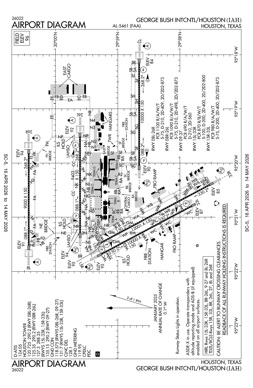
Runway 15L/33R:
12,001ft
Runway 09/27:
10,000ft
Runway 15R/33L:
10,000ft
Runway 08R/26L:
9,402ft
Runway 08L/26R:
9,000ft
Access: Open to the public
Current Weather — MVFR
-
Weather data is strictly informational and not for flight planning purposes.
-
METAR2026-05-23 10:53:00 CDT
Ceiling: 2,200ft Wind: 330° @ 5kt Temperature: 78°F Dewpoint: 69°F Weather: N/A Visbility: 10SM Clouds: Broken @ 2,200ft, Overcast @ 3,400ft Raw:METAR KIAH 231553Z 33005KT 10SM BKN022 OVC034 26/21 A2993 RMK AO2 SLP134 T02610211 -
TAF2026-05-23 10:00:00 CDT – 2026-05-23 15:00:00 CDT
Ceiling: 25,000ft Wind: 330° @ 5kt Weather: N/A Visbility: 6SM Clouds: Few @ 2,000ft, Scattered @ 3,000ft, Broken @ 25,000ft Raw:TAF KIAH 231506Z 2315/2418 33005KT P6SM FEW020 SCT030 BKN250 FM232000 16008KT 6SM -SHRA BR VCTS BKN035CB OVC050 TEMPO 2320/2324 VRB10G20KT 4SM TSRA BR BKN025CB BKN050 FM240000 09005KT P6SM VCSH OVC050 FM240600 VRB05KT P6SM BKN030 OVC100 -
TAF2026-05-23 15:00:00 CDT – 2026-05-23 19:00:00 CDT
Ceiling: 3,500ft Wind: 160° @ 8kt Weather: Light rain showers, mist, thunderstorm in vicinity Visbility: 6SM Clouds: Broken @ 3,500ft, Overcast @ 5,000ft Raw:TAF KIAH 231506Z 2315/2418 33005KT P6SM FEW020 SCT030 BKN250 FM232000 16008KT 6SM -SHRA BR VCTS BKN035CB OVC050 TEMPO 2320/2324 VRB10G20KT 4SM TSRA BR BKN025CB BKN050 FM240000 09005KT P6SM VCSH OVC050 FM240600 VRB05KT P6SM BKN030 OVC100 -
TAF2026-05-23 15:00:00 CDT – 2026-05-23 19:00:00 CDT
Ceiling: 2,500ft Wind: Variable, gusts 20kt Weather: Thunderstorm rain, mist Visbility: 4SM Clouds: Broken @ 2,500ft, Broken @ 5,000ft Raw:TAF KIAH 231506Z 2315/2418 33005KT P6SM FEW020 SCT030 BKN250 FM232000 16008KT 6SM -SHRA BR VCTS BKN035CB OVC050 TEMPO 2320/2324 VRB10G20KT 4SM TSRA BR BKN025CB BKN050 FM240000 09005KT P6SM VCSH OVC050 FM240600 VRB05KT P6SM BKN030 OVC100 -
TAF2026-05-23 19:00:00 CDT – 2026-05-24 01:00:00 CDT
Ceiling: 5,000ft Wind: 090° @ 5kt Weather: Showers in vicinity Visbility: 6SM Clouds: Overcast @ 5,000ft Raw:TAF KIAH 231506Z 2315/2418 33005KT P6SM FEW020 SCT030 BKN250 FM232000 16008KT 6SM -SHRA BR VCTS BKN035CB OVC050 TEMPO 2320/2324 VRB10G20KT 4SM TSRA BR BKN025CB BKN050 FM240000 09005KT P6SM VCSH OVC050 FM240600 VRB05KT P6SM BKN030 OVC100 -
TAF2026-05-24 01:00:00 CDT – 2026-05-24 13:00:00 CDT
Ceiling: 3,000ft Wind: Variable Weather: N/A Visbility: 6SM Clouds: Broken @ 3,000ft, Overcast @ 10,000ft Raw:TAF KIAH 231506Z 2315/2418 33005KT P6SM FEW020 SCT030 BKN250 FM232000 16008KT 6SM -SHRA BR VCTS BKN035CB OVC050 TEMPO 2320/2324 VRB10G20KT 4SM TSRA BR BKN025CB BKN050 FM240000 09005KT P6SM VCSH OVC050 FM240600 VRB05KT P6SM BKN030 OVC100
Click/tap to add an annotation marker to the map
No webcams added yet.
Remarks
- Birds on & invof arpt.
- Txln 'ra', 'rb', 'rc', 'r2', and twy 'sc' north of twy 'sb' are dsgnd non-movement areas operd by ual ramp ctl.
- 9 ft agl unmkd security fence adj to fbo & corporate base opr ramps and nonmov area txls.
- Twy 'nr' clsd to acft with wing spans greater than 125 ft btn twy 'wd' & twy 'wb'.
- Twy 'sf' btn twy 'nb' and txl 'ra' is dsgnd non-mov area.
Comments