Pirep is a free, collaborative database of all public and private airports. All pilots are welcome to contribute their local knowledge to any airport, no registration required.


Public
Undocumented
METAR / TAF
Edit Tags
No upcoming events. Is anything happening here soon?
Airport Statistics
- Webcam links
- Transient parking location
- Tags
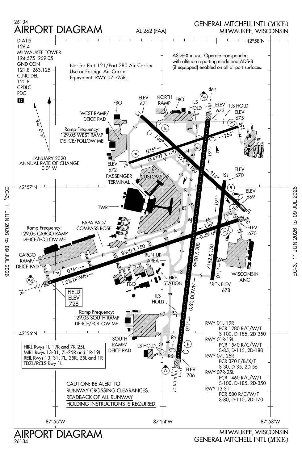
Location:
Milwaukee, WI
Elevation:
728ft
Sectional:
Chicago
Fuel:
100LL, A (prices)
Runway 01L/19R:
9,990ft
Runway 07R/25L:
8,300ft
Runway 13/31:
5,537ft
Runway 07L/25R:
4,797ft
Runway 01R/19L:
4,182ft
Access: Open to the public
Current Weather — VFR
-
Weather data is strictly informational and not for flight planning purposes.
-
METAR2026-07-14 04:52:00 CDT
Ceiling: Sky clear Wind: 250° @ 4kt Temperature: 77°F Dewpoint: 68°F Weather: N/A Visbility: 10SM Clouds: Few @ 20,000ft Raw:METAR KMKE 140952Z 25004KT 10SM FEW200 25/20 A3015 RMK AO2 SLP203 T02500200 -
TAF2026-07-14 04:00:00 CDT – 2026-07-14 11:00:00 CDT
Ceiling: Sky clear Wind: 260° @ 7kt Weather: N/A Visbility: 6SM Clouds: @ ft Raw:TAF KMKE 140903Z 1409/1512 26007KT P6SM SKC FM141600 27008KT P6SM SKC FM142100 24007KT P6SM SKC -
TAF2026-07-14 11:00:00 CDT – 2026-07-14 16:00:00 CDT
Ceiling: Sky clear Wind: 270° @ 8kt Weather: N/A Visbility: 6SM Clouds: @ ft Raw:TAF KMKE 140903Z 1409/1512 26007KT P6SM SKC FM141600 27008KT P6SM SKC FM142100 24007KT P6SM SKC -
TAF2026-07-14 16:00:00 CDT – 2026-07-15 07:00:00 CDT
Ceiling: Sky clear Wind: 240° @ 7kt Weather: N/A Visbility: 6SM Clouds: @ ft Raw:TAF KMKE 140903Z 1409/1512 26007KT P6SM SKC FM141600 27008KT P6SM SKC FM142100 24007KT P6SM SKC
Click/tap to add an annotation marker to the map
No webcams added yet.
Remarks
- Arff index d equip avbl upon request.
- Ry 07l/25r clsd to all jet acft.
- Ry 13/31 clsd jet acft, unless pmsn from twr or amgr 414-747-5325.
- Trng flgts involving successive use of any ry prohibited 2200-0600.
- Rwy 13/31 & 07l/25r clsd exc lgt wt sngl eng acft 0400-1200z dly.
Comments