Pirep is a free, collaborative database of all public and private airports. All pilots are welcome to contribute their local knowledge to any airport, no registration required.


Public
Undocumented
METAR / TAF
Edit Tags
No upcoming events. Is anything happening here soon?
Airport Statistics
- WiFi availability
- General description
- Fuel pump location
Location:
Pittsburgh, PA
Elevation:
1,202ft
Sectional:
Detroit
Activation date:
Mar 1944
Fuel:
100LL, A (prices)
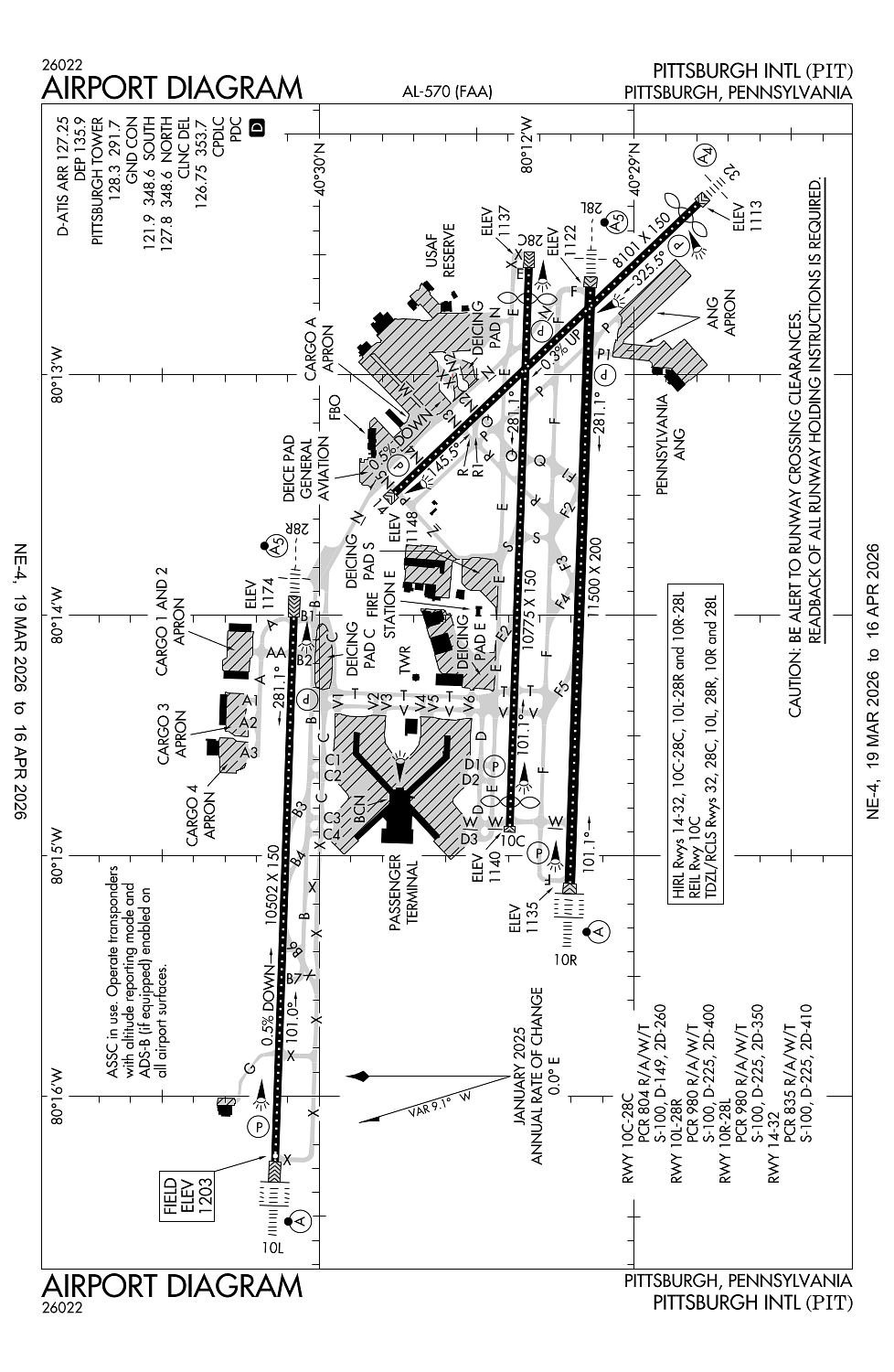
Runway 10R/28L:
11,500ft
Runway 10C/28C:
10,775ft
Runway 10L/28R:
10,502ft
Runway 14/32:
8,101ft
Access: Open to the public
Current Weather — VFR
-
Weather data is strictly informational and not for flight planning purposes.
-
METAR2026-03-25 00:51:00 EDT
Ceiling: 11,000ft Wind: 020° @ 5kt Temperature: 39°F Dewpoint: 21°F Weather: N/A Visbility: 10SM Clouds: Broken @ 11,000ft, Overcast @ 20,000ft Raw:METAR KPIT 250451Z 02005KT 10SM BKN110 OVC200 04/M06 A3030 RMK AO2 SLP277 T00441061 400831061 -
TAF2026-03-25 02:00:00 EDT – 2026-03-25 12:00:00 EDT
Ceiling: 12,000ft Wind: Variable Weather: N/A Visbility: 6SM Clouds: Broken @ 12,000ft Raw:TAF KPIT 250520Z 2506/2612 VRB03KT P6SM BKN120 FM251600 18008KT P6SM BKN150 FM260900 22008KT P6SM BKN035 -
TAF2026-03-25 12:00:00 EDT – 2026-03-26 05:00:00 EDT
Ceiling: 15,000ft Wind: 180° @ 8kt Weather: N/A Visbility: 6SM Clouds: Broken @ 15,000ft Raw:TAF KPIT 250520Z 2506/2612 VRB03KT P6SM BKN120 FM251600 18008KT P6SM BKN150 FM260900 22008KT P6SM BKN035 -
TAF2026-03-26 05:00:00 EDT – 2026-03-26 08:00:00 EDT
Ceiling: 3,500ft Wind: 220° @ 8kt Weather: N/A Visbility: 6SM Clouds: Broken @ 3,500ft Raw:TAF KPIT 250520Z 2506/2612 VRB03KT P6SM BKN120 FM251600 18008KT P6SM BKN150 FM260900 22008KT P6SM BKN035
Click/tap to add an annotation marker to the map
No webcams added yet.
Remarks
- In opern prior to 1959.
- Deer & birds on & invof arpt.
- All jets departing ry 28r must be aligned wi ry prior to applying tkof power.
- Acft using twy 'n' prohibited to stop on overpass area due to possible emergency evacuation hazard.
- Ang acft must ctc tanker 303.0/ftr opns 293.7 before crossing rwy 28l to obtain clnc to enter.
Comments