Pirep is a free, collaborative database of all public and private airports. All pilots are welcome to contribute their local knowledge to any airport, no registration required.


No upcoming events. Is anything happening here soon?
Last updated: 2023-05-31 19:30:01 PDT
Airport Statistics
- WiFi availability
- Transient parking location
- Crew car availability
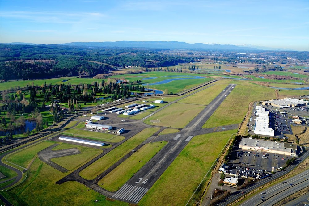
Location:
Salinas, CA
Elevation:
84ft
Sectional:
San Francisco
Activation date:
Jun 1942
Fuel:
100LL, A (prices)
Runway 08/26:
6,004ft
Runway 13/31:
4,825ft
Runway H1:
90ft
Access: Open to the public
Similar Airports
Current Weather — VFR
-
Weather data is strictly informational and not for flight planning purposes.
-
METAR2025-12-13 14:53:00 PST
Ceiling: Sky clear Wind: 310° @ 8kt Temperature: 62°F Dewpoint: 51°F Weather: N/A Visbility: 10SM Raw:METAR KSNS 132253Z 31008KT 10SM CLR 17/11 A3001 RMK AO2 SLP171 T01670106 -
TAF2025-12-13 10:00:00 PST – 2025-12-13 14:00:00 PST
Ceiling: Sky clear Wind: 140° @ 8kt Weather: N/A Visbility: 6SM Clouds: @ ft Raw:TAF KSNS 131740Z 1318/1418 14008KT P6SM SKC FM132200 34005KT P6SM SKC FM140200 32006KT 6SM BR OVC003 FM140700 12004KT 5SM BR OVC003 -
TAF2025-12-13 14:00:00 PST – 2025-12-13 18:00:00 PST
Ceiling: Sky clear Wind: 340° @ 5kt Weather: N/A Visbility: 6SM Clouds: @ ft Raw:TAF KSNS 131740Z 1318/1418 14008KT P6SM SKC FM132200 34005KT P6SM SKC FM140200 32006KT 6SM BR OVC003 FM140700 12004KT 5SM BR OVC003 -
TAF2025-12-13 18:00:00 PST – 2025-12-13 23:00:00 PST
Ceiling: 300ft Wind: 320° @ 6kt Weather: Mist Visbility: 6SM Clouds: Overcast @ 300ft Raw:TAF KSNS 131740Z 1318/1418 14008KT P6SM SKC FM132200 34005KT P6SM SKC FM140200 32006KT 6SM BR OVC003 FM140700 12004KT 5SM BR OVC003 -
TAF2025-12-13 23:00:00 PST – 2025-12-14 10:00:00 PST
Ceiling: 300ft Wind: 120° @ 4kt Weather: Mist Visbility: 5SM Clouds: Overcast @ 300ft Raw:TAF KSNS 131740Z 1318/1418 14008KT P6SM SKC FM132200 34005KT P6SM SKC FM140200 32006KT 6SM BR OVC003 FM140700 12004KT 5SM BR OVC003
Click/tap to add an annotation marker to the map

No webcams added yet.
Remarks
- Portions of twy b between d & n limited atct services provided
- 6 ft tall security fence 400 ft prior to ry 13 thld on cntrln and steeply descending terrain 350 ft prior to ry 31 thld on cntrln both in ry 13/31 safety area.
- For cd when atct is clsd ctc norcal apch at 916-361-3748.
- When atct clsd actvt malsr rwy 31; reil rwy 13 & 26; papi rwy 31; hirl rwy 13/31; mirl rwy 08/26; h1 - ctaf. vasi rwy 08, 13, & 26 opr consly.
- 200 ft asph stwy ry 31.
Comments