Pirep is a free, collaborative database of all public and private airports located within the United States. All pilots are welcome to contribute, edit, and improve any airport they have local knowledge about, no registration required.
Upcoming Events
No upcoming events. Is anything happening here soon?
Last updated: 2023-10-25 21:13:05 PDT
Last updated: 2023-11-07 00:06:26 PST
Last updated: 2023-11-07 00:06:26 PST
Last updated: 2023-11-14 21:20:12 PST
Airport Statistics
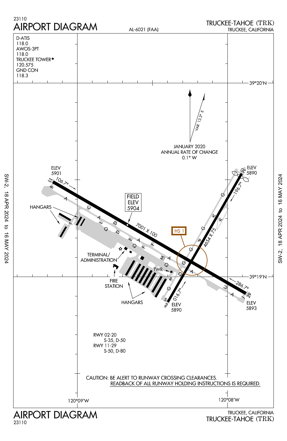
Location:
Truckee, CA
Elevation:
5,904ft
Sectional:
San Francisco
Activation date:
Oct 1962
Fuel:
100LL, A, A1+ (prices)
Runway 11/29:
7,001ft
Runway 02/20:
4,654ft
Access: Open to the public
Current Weather — IFR
-
Weather data is strictly informational and not for flight planning purposes.
-
METAR2024-05-05 04:15:00 PDT
Ceiling Wind Temperature Dewpoint Weather Visbility 1,000ft Calm 24°F 23°F Snow 1SM Clouds: Overcast @ 1,000ft Raw:KTRK 051115Z AUTO 00000KT 1SM SN OVC010 M04/M05 A2979 RMK AO2 -
TAF2024-05-05 05:00:00 PDT – 2024-05-05 09:00:00 PDT
Ceiling Wind Weather Visbility 1,000ft 210° @ 7kt Light snow showers 2SM Clouds: Broken @ 1,000ft, Overcast @ 4,000ft Raw:KTRK 051120Z 0512/0612 21007KT 2SM -SHSN BKN010 OVC040 FM051600 26011G20KT P6SM BKN040 FM060300 18004KT P6SM BKN130 -
TAF2024-05-05 09:00:00 PDT – 2024-05-05 20:00:00 PDT
Ceiling Wind Weather Visbility 4,000ft 260° @ 11kt, gusts 20kt N/A 6SM Clouds: Broken @ 4,000ft Raw:KTRK 051120Z 0512/0612 21007KT 2SM -SHSN BKN010 OVC040 FM051600 26011G20KT P6SM BKN040 FM060300 18004KT P6SM BKN130 -
TAF2024-05-05 20:00:00 PDT – 2024-05-06 05:00:00 PDT
Ceiling Wind Weather Visbility 13,000ft 180° @ 4kt N/A 6SM Clouds: Broken @ 13,000ft Raw:KTRK 051120Z 0512/0612 21007KT 2SM -SHSN BKN010 OVC040 FM051600 26011G20KT P6SM BKN040 FM060300 18004KT P6SM BKN130
Click/tap to add an annotation marker to the map
Remarks
- When atct clsd.
- Rwy 20 & rwy 11 dist-to-go mkrs instld on left side.
- Summer density alts in aftns frqly exceed 9000 ft.
- Wildlife on and invof arpt.
- Gldr and skydiving opns ne of arpt may-sep.
Very GA-friendly airport with attentive staff. Be mindful of the noise abatement procedure off all four rwys 11/29 and 02/20 - you’ll get a letter in the mail if you deviate, as the locals like to report those who don’t follow the plan. It’s easy - just know before you go. Plan posters all over the airport, and ATC can help you if you can’t find it.