Pirep is a free, collaborative database of all public and private airports located within the United States. All pilots are welcome to contribute, edit, and improve any airport they have local knowledge about, no registration required.
Upcoming Events
No upcoming events. Is anything happening here soon?
Last updated: 2023-06-15 23:32:53 CDT
Airport Statistics
Location:
Tulsa, OK
Elevation:
677ft
Sectional:
Kansas City
Activation date:
Aug 1942
Fuel:
100LL, A (prices)
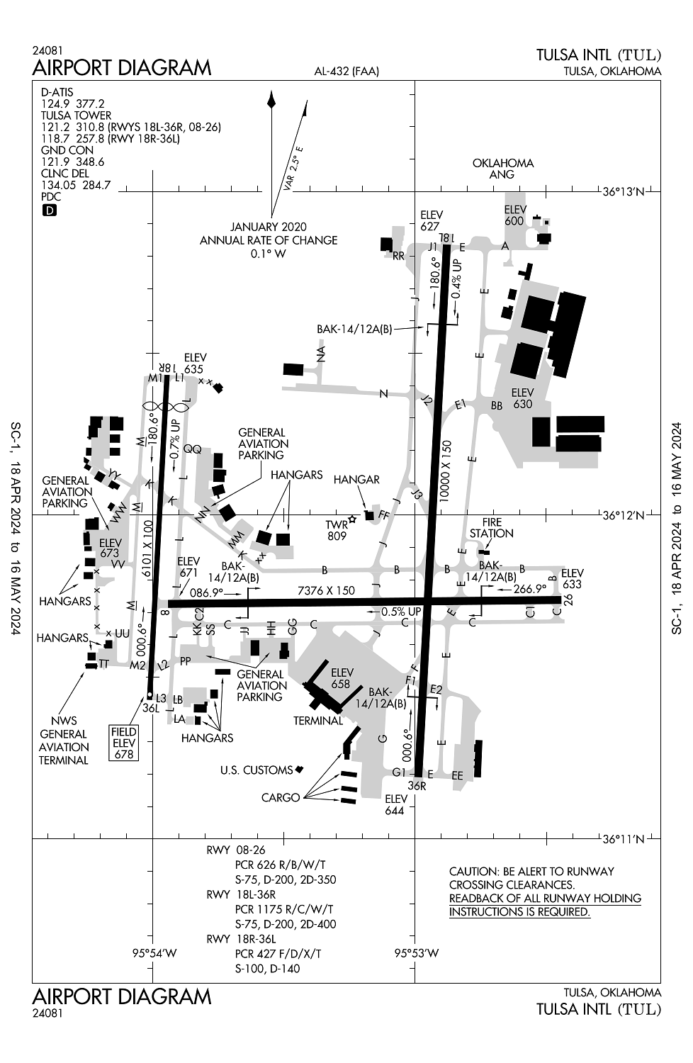
Runway 18L/36R:
10,000ft
Runway 08/26:
7,376ft
Runway 18R/36L:
6,101ft
Access: Open to the public
Current Weather — VFR
-
Weather data is strictly informational and not for flight planning purposes.
-
METAR2024-05-14 09:53:00 CDT
Ceiling Wind Temperature Dewpoint Weather Visbility Sky clear 340° @ 10kt 66°F 55°F N/A 7SM Raw:KTUL 141453Z 34010KT 7SM CLR 19/13 A2979 RMK AO2 SLP083 T01940133 51014 -
TAF2024-05-14 07:00:00 CDT – 2024-05-14 10:00:00 CDT
Ceiling Wind Weather Visbility Sky clear 310° @ 8kt N/A 6SM Clouds: Scattered @ 2,400ft Raw:KTUL 141120Z 1412/1512 31008KT P6SM SCT024 FM141500 33011KT P6SM FEW040 FEW250 FM150000 VRB03KT P6SM SKC -
TAF2024-05-14 10:00:00 CDT – 2024-05-14 19:00:00 CDT
Ceiling Wind Weather Visbility Sky clear 330° @ 11kt N/A 6SM Clouds: Few @ 4,000ft, Few @ 25,000ft Raw:KTUL 141120Z 1412/1512 31008KT P6SM SCT024 FM141500 33011KT P6SM FEW040 FEW250 FM150000 VRB03KT P6SM SKC -
TAF2024-05-14 19:00:00 CDT – 2024-05-15 07:00:00 CDT
Ceiling Wind Weather Visbility Sky clear Variable N/A 6SM Clouds: @ ft Raw:KTUL 141120Z 1412/1512 31008KT P6SM SCT024 FM141500 33011KT P6SM FEW040 FEW250 FM150000 VRB03KT P6SM SKC
Click/tap to add an annotation marker to the map
No webcams added yet.
Remarks
- Ctn: 4000 ft blacktop track 1.5 nm e rwy 26; do not mistake for rwy.
- Wt rstrd areas: twy jj s-35; twy m2 s-81/d-140/dt-186; twy hh s-55/d-60; twy l north of rwy 08/26 s-93/d-140/dt 209; twy l btn twy c & twy l2 s-120/d-250/dt 372; twy l2 s-70/d-100/dt-166.
- Noise abatement all rwys: climb to 3000 ft asap aft tkof.
- Ireg wind pat aer 18r.
- Txl la, nn & qq not vsb fm atct.
Comments