Pirep is a free, collaborative database of all public and private airports. All pilots are welcome to contribute their local knowledge to any airport, no registration required.
Undocumented
METAR / TAF
Edit Tags
No upcoming events. Is anything happening here soon?
Airport Statistics
- Transient parking location
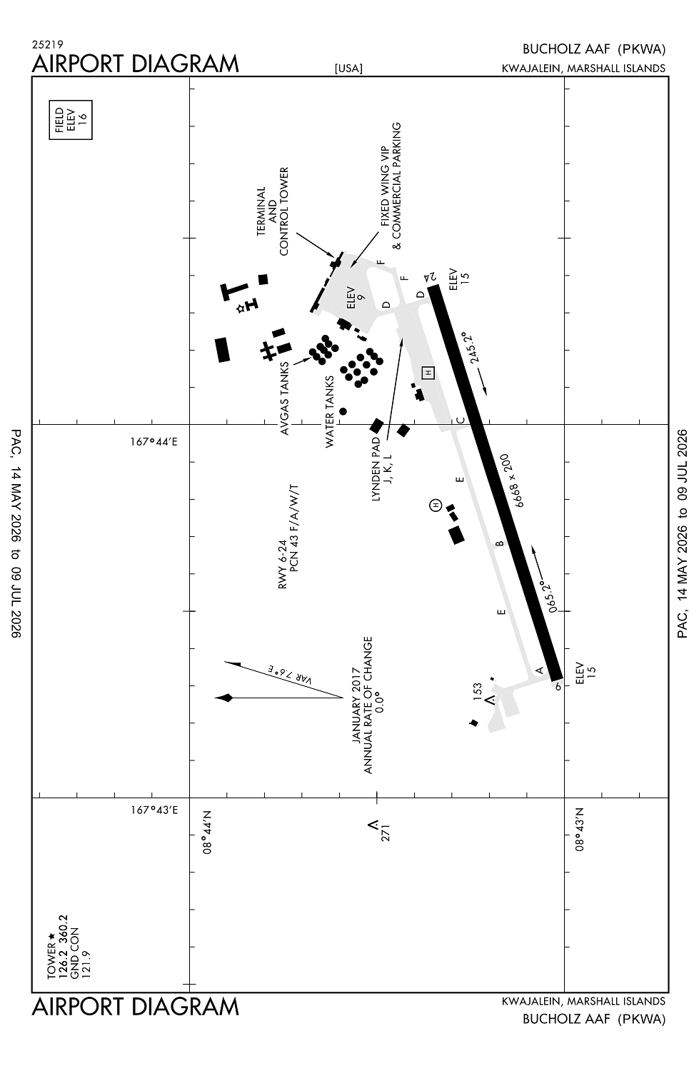
- General description
- Airport map annotations
Location:
Kwajalein, MH
Elevation:
15ft
Sectional:
Gnc Seven
Fuel:
None
Runway 06/24:
6,668ft
Access: Private to everyone
This is a military facility.
Current Weather — VFR
-
Weather data is strictly informational and not for flight planning purposes.
-
METAR2026-07-21 17:20:00 +12
Ceiling: Sky clear Wind: 050° @ 8kt Temperature: 86°F Dewpoint: 76°F Weather: N/A Visbility: 10SM Clouds: Scattered @ 2,300ft, Scattered @ 3,000ft Raw:METAR PKWA 210520Z AUTO 05008KT 10SM SCT023 SCT030 30/25 A2977 RMK AO2 T03000245 -
TAF2026-07-21 12:00:00 +12 – 2026-07-22 12:00:00 +12
Ceiling: Sky clear Wind: 050° @ 10kt Weather: Showers in vicinity Visbility: 6SM Clouds: Few @ 2,000ft, Scattered @ 4,000ft Raw:TAF PKWA 202320Z 2100/2124 05010KT P6SM VCSH FEW020 SCT040
Click/tap to add an annotation marker to the map
No webcams added yet.
Remarks
- 24 hr ppr thru cmdr us army kwajalein atoll; p.o. box 26 apo ap 96555; attn: ctc base ops, pacific dsn 480-2131, c808-580-2131.
- 250 ft twr 8.5nm pkwa brg 300deg.
- Ctn-pilots have experienced vertigo dur ngt operns especially dur periods of reduced vis due to lack of visual cues.
- Afct with explosive cargo should plan to arrive between 0830-1730 lcl.
- Caution: men, equip, and vehicles may be opr in close proximity to the rwy. 250 ft twr 8.5 nm wnw. vertigo potential exists dur ngt opr especially dur periods of reduced vis due lack of vis cues. avoid rain catchments on n side of rwy and twy. portions of twy e not vis fr twr. no ovrn avbl. numerous trees and other obst within 300 ft s of rwy. seawall at ea end of rwy. electro-magnetic radiation may exist 24 hr dly within 5 nm sfc to 30,000 ft. ctc base ops or twr prior to arr and dep for electro-magnetic radiation haz de-confliction.
Comments