Pirep is a free, collaborative database of all public and private airports. All pilots are welcome to contribute their local knowledge to any airport, no registration required.
Undocumented
METAR / TAF
Edit Tags
No upcoming events. Is anything happening here soon?
Airport Statistics
- Landing & tie-down fees
- Airport map annotations
- Fuel pump location
Location:
Glendale, AZ
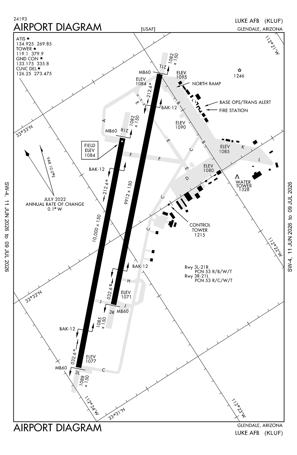
Elevation:
1,083ft
Sectional:
Phoenix
Activation date:
Sep 1943
Fuel:
A++ (prices)
Runway 03L/21R:
10,000ft
Runway 03R/21L:
9,912ft
Access: Private to everyone
This is a military facility.
Current Weather — VFR
-
Weather data is strictly informational and not for flight planning purposes.
-
METAR2026-07-20 22:55:00 MST
Ceiling: Sky clear Wind: 120° @ 6kt Temperature: 87°F Dewpoint: 63°F Weather: N/A Visbility: 10SM Raw:METAR KLUF 210555Z AUTO 12006KT 10SM M 31/18 A2986 RMK AO2 SLP094 60012 T03060176 10413 20299 51039 CHINO RWY03 $ -
TAF2026-07-20 21:00:00 MST – 2026-07-21 00:00:00 MST
Ceiling: 8,000ft Wind: Variable, gusts 40kt Weather: Thunderstorm in vicinity Visbility: SM Clouds: Broken @ 8,000ft Raw:TAF KLUF 210400Z 2104/2210 22010G15KT 9999 SCT090 OVC130 QNH2981INS VRB06KT AFT 2107 TEMPO 2104/2107 VRB20G40KT VCTS BKN080CB BECMG 2120/2121 21010G15KT 9999 BKN120 QNH2977INS BECMG 2202/2203 20010G20KT 9999 -SHRA FEW080 BKN110 QNH2980INS TX35/2200Z TN26/2113Z -
TAF2026-07-20 21:00:00 MST – 2026-07-21 13:00:00 MST
Ceiling: 13,000ft Wind: 220° @ 10kt, gusts 15kt Weather: N/A Visbility: 6SM Clouds: Scattered @ 9,000ft, Overcast @ 13,000ft Raw:TAF KLUF 210400Z 2104/2210 22010G15KT 9999 SCT090 OVC130 QNH2981INS VRB06KT AFT 2107 TEMPO 2104/2107 VRB20G40KT VCTS BKN080CB BECMG 2120/2121 21010G15KT 9999 BKN120 QNH2977INS BECMG 2202/2203 20010G20KT 9999 -SHRA FEW080 BKN110 QNH2980INS TX35/2200Z TN26/2113Z -
TAF2026-07-21 13:00:00 MST – 2026-07-21 19:00:00 MST
Ceiling: 12,000ft Wind: 210° @ 10kt, gusts 15kt Weather: N/A Visbility: 6SM Clouds: Broken @ 12,000ft Raw:TAF KLUF 210400Z 2104/2210 22010G15KT 9999 SCT090 OVC130 QNH2981INS VRB06KT AFT 2107 TEMPO 2104/2107 VRB20G40KT VCTS BKN080CB BECMG 2120/2121 21010G15KT 9999 BKN120 QNH2977INS BECMG 2202/2203 20010G20KT 9999 -SHRA FEW080 BKN110 QNH2980INS TX35/2200Z TN26/2113Z -
TAF2026-07-21 19:00:00 MST – 2026-07-22 03:00:00 MST
Ceiling: 11,000ft Wind: 200° @ 10kt, gusts 20kt Weather: Light rain showers Visbility: 6SM Clouds: Few @ 8,000ft, Broken @ 11,000ft Raw:TAF KLUF 210400Z 2104/2210 22010G15KT 9999 SCT090 OVC130 QNH2981INS VRB06KT AFT 2107 TEMPO 2104/2107 VRB20G40KT VCTS BKN080CB BECMG 2120/2121 21010G15KT 9999 BKN120 QNH2977INS BECMG 2202/2203 20010G20KT 9999 -SHRA FEW080 BKN110 QNH2980INS TX35/2200Z TN26/2113Z
Click/tap to add an annotation marker to the map
No webcams added yet.
Remarks
- Dusk-0530z mon-thur, dusk-0130z fri.
- Rdcd level arff cpbltys cat 1-7; critical level arff cpbltys cat 8-10; wkend & hol further rdc cpbltys. svr risk loss; arff not expd to extinguish interior fire or successful rescue ops. ltd exterior arff performed - amgmt to verify.
- Rstd: hover ldg na wo atct perm.
- Rstd: ppr all acft - d896-7131/ c623-856-7131/7132; ppr arr block time +/- 30 min of sked ldg.
- Tsnt must coord apvl for lcl sorties prior to arr. tsnt classified storage na at amops; ctc command post for storage - d896-5600/c623-856-5600.
Comments