Pirep is a free, collaborative database of all public and private airports. All pilots are welcome to contribute their local knowledge to any airport, no registration required.


Public
Undocumented
METAR / TAF
Edit Tags
No upcoming events. Is anything happening here soon?
Airport Statistics
- Tags
- Airport map annotations
- Local flying clubs
Location:
Mobile, AL
Elevation:
218ft
Sectional:
New Orleans
Activation date:
Apr 1942
Fuel:
100LL, A, A+ (prices)
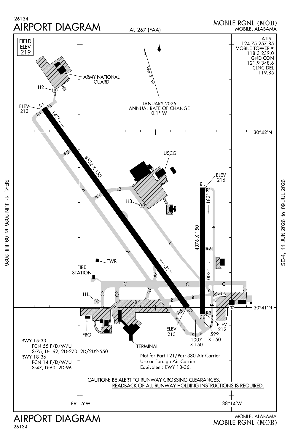
Runway 15/33:
8,502ft
Runway 18/36:
4,376ft
Runway H1:
100ft
Runway H2:
60ft
Runway H3:
60ft
Access: Open to the public
Current Weather — VFR
-
Weather data is strictly informational and not for flight planning purposes.
-
METAR2026-07-16 01:56:00 CDT
Ceiling: Sky clear Wind: 270° @ 3kt Temperature: 75°F Dewpoint: 69°F Weather: N/A Visbility: 10SM Raw:METAR KMOB 160656Z AUTO 27003KT 10SM CLR 24/21 A3011 RMK AO2 SLP194 T02440211 -
TAF2026-07-16 01:00:00 CDT – 2026-07-16 09:00:00 CDT
Ceiling: Sky clear Wind: 250° @ 3kt Weather: N/A Visbility: 6SM Clouds: Few @ 9,000ft, Few @ 20,000ft Raw:TAF KMOB 160520Z 1606/1706 25003KT P6SM FEW090 FEW200 FM161400 30005KT P6SM FEW250 FM161800 27006KT P6SM SCT050 SCT250 FM170200 26004KT P6SM FEW250 -
TAF2026-07-16 09:00:00 CDT – 2026-07-16 13:00:00 CDT
Ceiling: Sky clear Wind: 300° @ 5kt Weather: N/A Visbility: 6SM Clouds: Few @ 25,000ft Raw:TAF KMOB 160520Z 1606/1706 25003KT P6SM FEW090 FEW200 FM161400 30005KT P6SM FEW250 FM161800 27006KT P6SM SCT050 SCT250 FM170200 26004KT P6SM FEW250 -
TAF2026-07-16 13:00:00 CDT – 2026-07-16 21:00:00 CDT
Ceiling: Sky clear Wind: 270° @ 6kt Weather: N/A Visbility: 6SM Clouds: Scattered @ 5,000ft, Scattered @ 25,000ft Raw:TAF KMOB 160520Z 1606/1706 25003KT P6SM FEW090 FEW200 FM161400 30005KT P6SM FEW250 FM161800 27006KT P6SM SCT050 SCT250 FM170200 26004KT P6SM FEW250 -
TAF2026-07-16 21:00:00 CDT – 2026-07-17 01:00:00 CDT
Ceiling: Sky clear Wind: 260° @ 4kt Weather: N/A Visbility: 6SM Clouds: Few @ 25,000ft Raw:TAF KMOB 160520Z 1606/1706 25003KT P6SM FEW090 FEW200 FM161400 30005KT P6SM FEW250 FM161800 27006KT P6SM SCT050 SCT250 FM170200 26004KT P6SM FEW250
Click/tap to add an annotation marker to the map
No webcams added yet.
Remarks
- This airport has been surveyed by the national geodetic survey.
- Arpt constd prior to faa act. airspace action not on file.
- Rvr unavbl when atct clsd.
- Coast guard; w apron , e apron.
- Conds not mntd when atct clsd.
Comments