Pirep is a free, collaborative database of all public and private airports. All pilots are welcome to contribute their local knowledge to any airport, no registration required.
Undocumented
METAR / TAF
Edit Tags
No upcoming events. Is anything happening here soon?
Airport Statistics
- General description
- Fuel pump location
- Webcam links
Location:
Fort Indiantown Gap (Annville), PA
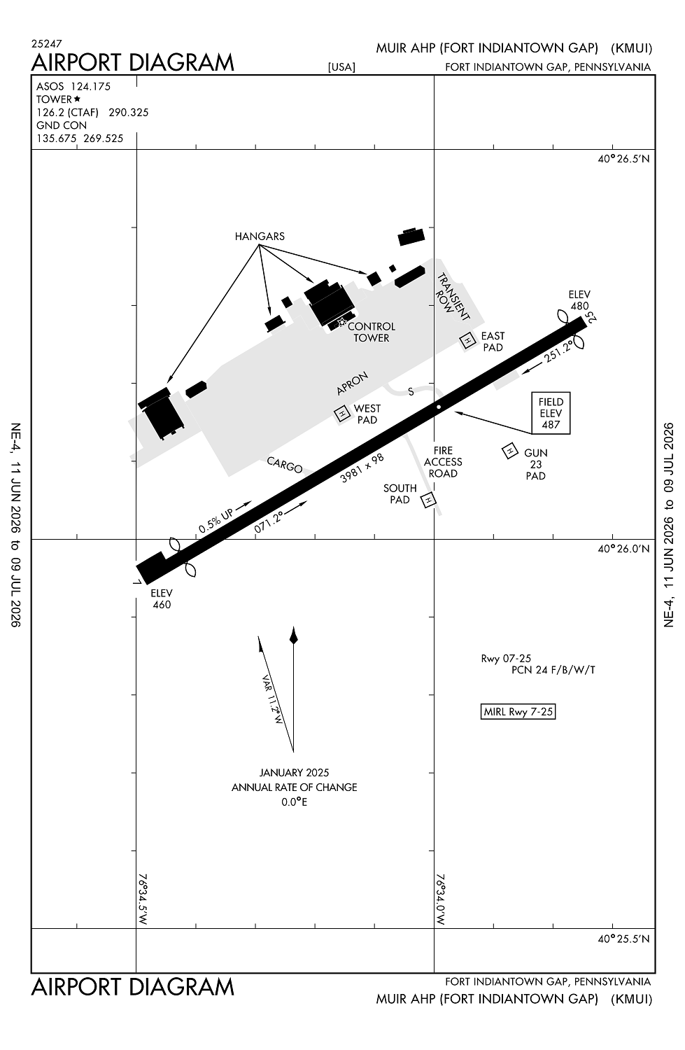
Elevation:
487ft
Sectional:
New York
Fuel:
None
Runway 07/25:
3,981ft
Runway H3:
120ft
Runway H1:
100ft
Runway H2:
100ft
Runway H4:
64ft
Access: Private to everyone
This is a military facility.
Current Weather — VFR
-
Weather data is strictly informational and not for flight planning purposes.
-
METAR2026-07-16 01:55:00 EDT
Ceiling: Sky clear Wind: Calm Temperature: 76°F Dewpoint: 69°F Weather: N/A Visbility: 10SM Raw:METAR KMUI 160555Z AUTO 00000KT 10SM CLR 25/21 A2993 RMK AO2 SLP133 T02460207 10315 20246 55001 -
TAF2026-07-15 23:00:00 EDT – 2026-07-16 10:00:00 EDT
Ceiling: Sky clear Wind: Variable Weather: N/A Visbility: 6SM Clouds: Scattered @ 3,500ft, Scattered @ 27,000ft Raw:TAF KMUI 160300Z 1603/1709 VRB03KT 9999 SCT035 SCT270 QNH2991INS TEMPO 1610/1613 9000 -SHRA SCT050 OVC080 BECMG 1614/1615 29006KT 9999 SCT035 QNH2994INS TX33/1619Z TN21/1610Z -
TAF2026-07-16 06:00:00 EDT – 2026-07-16 09:00:00 EDT
Ceiling: 8,000ft Wind: 000° @ kt Weather: Light rain showers Visbility: 5SM Clouds: Scattered @ 5,000ft, Overcast @ 8,000ft Raw:TAF KMUI 160300Z 1603/1709 VRB03KT 9999 SCT035 SCT270 QNH2991INS TEMPO 1610/1613 9000 -SHRA SCT050 OVC080 BECMG 1614/1615 29006KT 9999 SCT035 QNH2994INS TX33/1619Z TN21/1610Z -
TAF2026-07-16 10:00:00 EDT – 2026-07-17 05:00:00 EDT
Ceiling: Sky clear Wind: 290° @ 6kt Weather: N/A Visbility: 6SM Clouds: Scattered @ 3,500ft Raw:TAF KMUI 160300Z 1603/1709 VRB03KT 9999 SCT035 SCT270 QNH2991INS TEMPO 1610/1613 9000 -SHRA SCT050 OVC080 BECMG 1614/1615 29006KT 9999 SCT035 QNH2994INS TX33/1619Z TN21/1610Z
Click/tap to add an annotation marker to the map
No webcams added yet.
Remarks
- Lgtd water twr .7 nm w.
- Fuel: j8 - ppr, 24 hr wkd, 48 hr wkend, for fuel and prk thru arng ops c717-861-8963, dsn 491-8963.
- Rstd: ppr 24 hr wkd 48 hr wkend. ppr all tran acft. ctc ops dsn 491-8963, c717-861-8963.
- Caution: rwy has gradual 30' rise fr apch end rwy 07 to a pt 2800' up rwy, rwy ends not mutually vis. lgtd water twr .7 nm w and 0.5 nm s of afld.
- Tfc pat: r/w 1200' msl.
Comments