Pirep is a free, collaborative database of all public and private airports. All pilots are welcome to contribute their local knowledge to any airport, no registration required.
Undocumented
METAR / TAF
Edit Tags
No upcoming events. Is anything happening here soon?
Airport Statistics
- Webcam links
- Transient parking location
- WiFi availability
Location:
Montgomery, AL
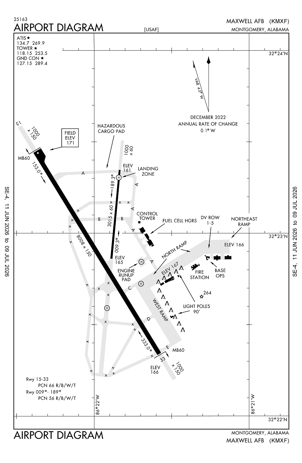
Elevation:
170ft
Sectional:
Atlanta
Activation date:
May 1941
Fuel:
None
Runway 15/33:
8,008ft
Runway 009/189:
3,015ft
Access: Private to everyone
This is a military facility.
Current Weather — VFR
-
Weather data is strictly informational and not for flight planning purposes.
-
METAR2026-07-20 23:55:00 CDT
Ceiling: Sky clear Wind: 060° @ 3kt Temperature: 79°F Dewpoint: 72°F Weather: N/A Visbility: 10SM Raw:METAR KMXF 210455Z AUTO 06003KT 10SM CLR 27/23 A2985 RMK AO2 SLP108 T02660226 -
TAF2026-07-20 22:00:00 CDT – 2026-07-21 05:00:00 CDT
Ceiling: 6,500ft Wind: 130° @ 6kt Weather: N/A Visbility: 6SM Clouds: Few @ 3,000ft, Broken @ 6,500ft, Overcast @ 9,000ft Raw:TAF KMXF 210300Z 2103/2209 13006KT 9999 FEW030 BKN065 OVC090 QNH2987INS BECMG 2110/2111 13009KT 8000 BR SCT008 BKN025 QNH2984INS TEMPO 2115/2122 9000 -SHRA BKN018 OVC040 BECMG 2121/2122 12010G25KT 9999 VCSH FEW040 OVC080 QNH2978INS TEMPO 2122/2206 12009KT 8000 -SHRA BKN040 OVC055 BECMG 2205/2206 12009KT 9999 NSW BKN015 OVC023 QNH2983INS TX34/2120Z TN24/2111Z LAST NO AMDS AFT 2105 NEXT 2111 -
TAF2026-07-21 05:00:00 CDT – 2026-07-21 16:00:00 CDT
Ceiling: 2,500ft Wind: 130° @ 9kt Weather: Mist Visbility: 4SM Clouds: Scattered @ 800ft, Broken @ 2,500ft Raw:TAF KMXF 210300Z 2103/2209 13006KT 9999 FEW030 BKN065 OVC090 QNH2987INS BECMG 2110/2111 13009KT 8000 BR SCT008 BKN025 QNH2984INS TEMPO 2115/2122 9000 -SHRA BKN018 OVC040 BECMG 2121/2122 12010G25KT 9999 VCSH FEW040 OVC080 QNH2978INS TEMPO 2122/2206 12009KT 8000 -SHRA BKN040 OVC055 BECMG 2205/2206 12009KT 9999 NSW BKN015 OVC023 QNH2983INS TX34/2120Z TN24/2111Z LAST NO AMDS AFT 2105 NEXT 2111 -
TAF2026-07-21 10:00:00 CDT – 2026-07-21 17:00:00 CDT
Ceiling: 1,800ft Wind: 000° @ kt Weather: Light rain showers Visbility: 5SM Clouds: Broken @ 1,800ft, Overcast @ 4,000ft Raw:TAF KMXF 210300Z 2103/2209 13006KT 9999 FEW030 BKN065 OVC090 QNH2987INS BECMG 2110/2111 13009KT 8000 BR SCT008 BKN025 QNH2984INS TEMPO 2115/2122 9000 -SHRA BKN018 OVC040 BECMG 2121/2122 12010G25KT 9999 VCSH FEW040 OVC080 QNH2978INS TEMPO 2122/2206 12009KT 8000 -SHRA BKN040 OVC055 BECMG 2205/2206 12009KT 9999 NSW BKN015 OVC023 QNH2983INS TX34/2120Z TN24/2111Z LAST NO AMDS AFT 2105 NEXT 2111 -
TAF2026-07-21 16:00:00 CDT – 2026-07-22 00:00:00 CDT
Ceiling: 8,000ft Wind: 120° @ 10kt, gusts 25kt Weather: Showers in vicinity Visbility: 6SM Clouds: Few @ 4,000ft, Overcast @ 8,000ft Raw:TAF KMXF 210300Z 2103/2209 13006KT 9999 FEW030 BKN065 OVC090 QNH2987INS BECMG 2110/2111 13009KT 8000 BR SCT008 BKN025 QNH2984INS TEMPO 2115/2122 9000 -SHRA BKN018 OVC040 BECMG 2121/2122 12010G25KT 9999 VCSH FEW040 OVC080 QNH2978INS TEMPO 2122/2206 12009KT 8000 -SHRA BKN040 OVC055 BECMG 2205/2206 12009KT 9999 NSW BKN015 OVC023 QNH2983INS TX34/2120Z TN24/2111Z LAST NO AMDS AFT 2105 NEXT 2111 -
TAF2026-07-21 17:00:00 CDT – 2026-07-22 01:00:00 CDT
Ceiling: 4,000ft Wind: 120° @ 9kt Weather: Light rain showers Visbility: 4SM Clouds: Broken @ 4,000ft, Overcast @ 5,500ft Raw:TAF KMXF 210300Z 2103/2209 13006KT 9999 FEW030 BKN065 OVC090 QNH2987INS BECMG 2110/2111 13009KT 8000 BR SCT008 BKN025 QNH2984INS TEMPO 2115/2122 9000 -SHRA BKN018 OVC040 BECMG 2121/2122 12010G25KT 9999 VCSH FEW040 OVC080 QNH2978INS TEMPO 2122/2206 12009KT 8000 -SHRA BKN040 OVC055 BECMG 2205/2206 12009KT 9999 NSW BKN015 OVC023 QNH2983INS TX34/2120Z TN24/2111Z LAST NO AMDS AFT 2105 NEXT 2111 -
TAF2026-07-22 00:00:00 CDT – 2026-07-22 04:00:00 CDT
Ceiling: 1,500ft Wind: 120° @ 9kt Weather: N/A Visbility: 6SM Clouds: Broken @ 1,500ft, Overcast @ 2,300ft Raw:TAF KMXF 210300Z 2103/2209 13006KT 9999 FEW030 BKN065 OVC090 QNH2987INS BECMG 2110/2111 13009KT 8000 BR SCT008 BKN025 QNH2984INS TEMPO 2115/2122 9000 -SHRA BKN018 OVC040 BECMG 2121/2122 12010G25KT 9999 VCSH FEW040 OVC080 QNH2978INS TEMPO 2122/2206 12009KT 8000 -SHRA BKN040 OVC055 BECMG 2205/2206 12009KT 9999 NSW BKN015 OVC023 QNH2983INS TX34/2120Z TN24/2111Z LAST NO AMDS AFT 2105 NEXT 2111
Click/tap to add an annotation marker to the map
No webcams added yet.
Remarks
- Jasu: 4(a/m32a-86d) 2(am32-95)
- Fuel: a++
- Fluid: sp lhox.
- Tran alert: airevac and dv acft will be given priority svcg.
- Rstd: dur bird watch cond code moderate and severe, aircrews should refer to ap/1 for bash hazard conditions and restrictions; aircrews can obtain current bird watch cond fr atis/ptd/twr.
Comments