Pirep is a free, collaborative database of all public and private airports. All pilots are welcome to contribute their local knowledge to any airport, no registration required.
Undocumented
METAR / TAF
Edit Tags
No upcoming events. Is anything happening here soon?
Airport Statistics
- Crew car availability
- Webcam links
- Tags
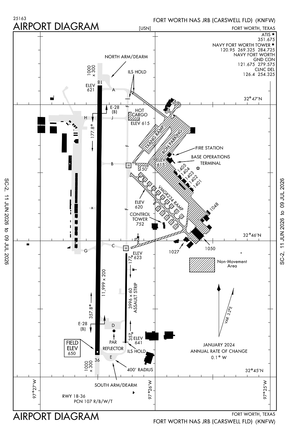
Location:
Fort Worth, TX
Elevation:
650ft
Sectional:
Dallas Ft Worth
Activation date:
Jul 1943
Fuel:
None
Runway 18/36:
11,999ft
Runway 176/356:
3,996ft
Access: Private to everyone
This is a military facility.
Current Weather — VFR
-
Weather data is strictly informational and not for flight planning purposes.
-
METAR2026-07-16 11:52:00 CDT
Ceiling: 3,600ft Wind: 180° @ 13kt, gusts 18kt Temperature: 84°F Dewpoint: 73°F Weather: N/A Visbility: 10SM Clouds: Scattered @ 2,600ft, Broken @ 3,600ft, Broken @ 15,000ft, Broken @ 25,000ft Raw:METAR KNFW 161652Z 18013G18KT 10SM SCT026 BKN036 BKN150 BKN250 29/23 A3011 RMK SLP179 T02940228 -
TAF2026-07-16 10:00:00 CDT – 2026-07-16 11:00:00 CDT
Ceiling: 2,800ft Wind: 150° @ 9kt Weather: N/A Visbility: 6SM Clouds: Scattered @ 1,800ft, Broken @ 2,800ft, Overcast @ 6,000ft Raw:TAF KNFW 161500Z 1615/1715 15009KT 9999 SCT018 BKN028 OVC060 QNH3005INS FM161600 17012KT 9999 SCT025 BKN045 OVC150 QNH3000INS FM162200 17015G22KT 9999 VCTS SCT035CB BKN100 OVC200 QNH2998INS FM170300 17009KT 9999 SCT022 BKN060 OVC100 QNH3002INS FM170900 19012G18KT 9999 BKN015 OVC022 QNH3004INS TX31/1621Z TN26/1707Z FN20046 -
TAF2026-07-16 11:00:00 CDT – 2026-07-16 17:00:00 CDT
Ceiling: 4,500ft Wind: 170° @ 12kt Weather: N/A Visbility: 6SM Clouds: Scattered @ 2,500ft, Broken @ 4,500ft, Overcast @ 15,000ft Raw:TAF KNFW 161500Z 1615/1715 15009KT 9999 SCT018 BKN028 OVC060 QNH3005INS FM161600 17012KT 9999 SCT025 BKN045 OVC150 QNH3000INS FM162200 17015G22KT 9999 VCTS SCT035CB BKN100 OVC200 QNH2998INS FM170300 17009KT 9999 SCT022 BKN060 OVC100 QNH3002INS FM170900 19012G18KT 9999 BKN015 OVC022 QNH3004INS TX31/1621Z TN26/1707Z FN20046 -
TAF2026-07-16 17:00:00 CDT – 2026-07-16 22:00:00 CDT
Ceiling: 10,000ft Wind: 170° @ 15kt, gusts 22kt Weather: Thunderstorm in vicinity Visbility: 6SM Clouds: Scattered @ 3,500ft, Broken @ 10,000ft, Overcast @ 20,000ft Raw:TAF KNFW 161500Z 1615/1715 15009KT 9999 SCT018 BKN028 OVC060 QNH3005INS FM161600 17012KT 9999 SCT025 BKN045 OVC150 QNH3000INS FM162200 17015G22KT 9999 VCTS SCT035CB BKN100 OVC200 QNH2998INS FM170300 17009KT 9999 SCT022 BKN060 OVC100 QNH3002INS FM170900 19012G18KT 9999 BKN015 OVC022 QNH3004INS TX31/1621Z TN26/1707Z FN20046 -
TAF2026-07-16 22:00:00 CDT – 2026-07-17 04:00:00 CDT
Ceiling: 6,000ft Wind: 170° @ 9kt Weather: N/A Visbility: 6SM Clouds: Scattered @ 2,200ft, Broken @ 6,000ft, Overcast @ 10,000ft Raw:TAF KNFW 161500Z 1615/1715 15009KT 9999 SCT018 BKN028 OVC060 QNH3005INS FM161600 17012KT 9999 SCT025 BKN045 OVC150 QNH3000INS FM162200 17015G22KT 9999 VCTS SCT035CB BKN100 OVC200 QNH2998INS FM170300 17009KT 9999 SCT022 BKN060 OVC100 QNH3002INS FM170900 19012G18KT 9999 BKN015 OVC022 QNH3004INS TX31/1621Z TN26/1707Z FN20046 -
TAF2026-07-17 04:00:00 CDT – 2026-07-17 10:00:00 CDT
Ceiling: 1,500ft Wind: 190° @ 12kt, gusts 18kt Weather: N/A Visbility: 6SM Clouds: Broken @ 1,500ft, Overcast @ 2,200ft Raw:TAF KNFW 161500Z 1615/1715 15009KT 9999 SCT018 BKN028 OVC060 QNH3005INS FM161600 17012KT 9999 SCT025 BKN045 OVC150 QNH3000INS FM162200 17015G22KT 9999 VCTS SCT035CB BKN100 OVC200 QNH2998INS FM170300 17009KT 9999 SCT022 BKN060 OVC100 QNH3002INS FM170900 19012G18KT 9999 BKN015 OVC022 QNH3004INS TX31/1621Z TN26/1707Z FN20046
Click/tap to add an annotation marker to the map
No webcams added yet.
Remarks
- Cstms/ag/img: us mil cstms sked 1400-2200z++ mon-fri 48 hr pn thru nas security dsn 739-5200, c817-782-5200.
- Caution: moderate and strong w wind reduced at td pt rwy 18 by lockheed complex. bird haz.
- Misc: rwy 18 first 1000 ft concrete, 6700 ft hi-friction asphalt, 2800 ft grooved concrete, remaining 1500 ft concrete, twy b east of twy f 50 ft.
- Bearing strength rwy 18/36: st175 sbtt593 trt585.
- Jasu: 1(ncpp-105) 1(nc-8) 4(am32a-86d) 7(am32a-60a).
Comments