Pirep is a free, collaborative database of all public and private airports. All pilots are welcome to contribute their local knowledge to any airport, no registration required.
Undocumented
METAR / TAF
Edit Tags
No upcoming events. Is anything happening here soon?
Airport Statistics
- Local flying clubs
- Fuel pump location
- Crew car availability
Location:
San Diego, CA
Elevation:
26ft
Sectional:
Los Angeles
Activation date:
May 1941
Fuel:
100LL, J5 (prices)
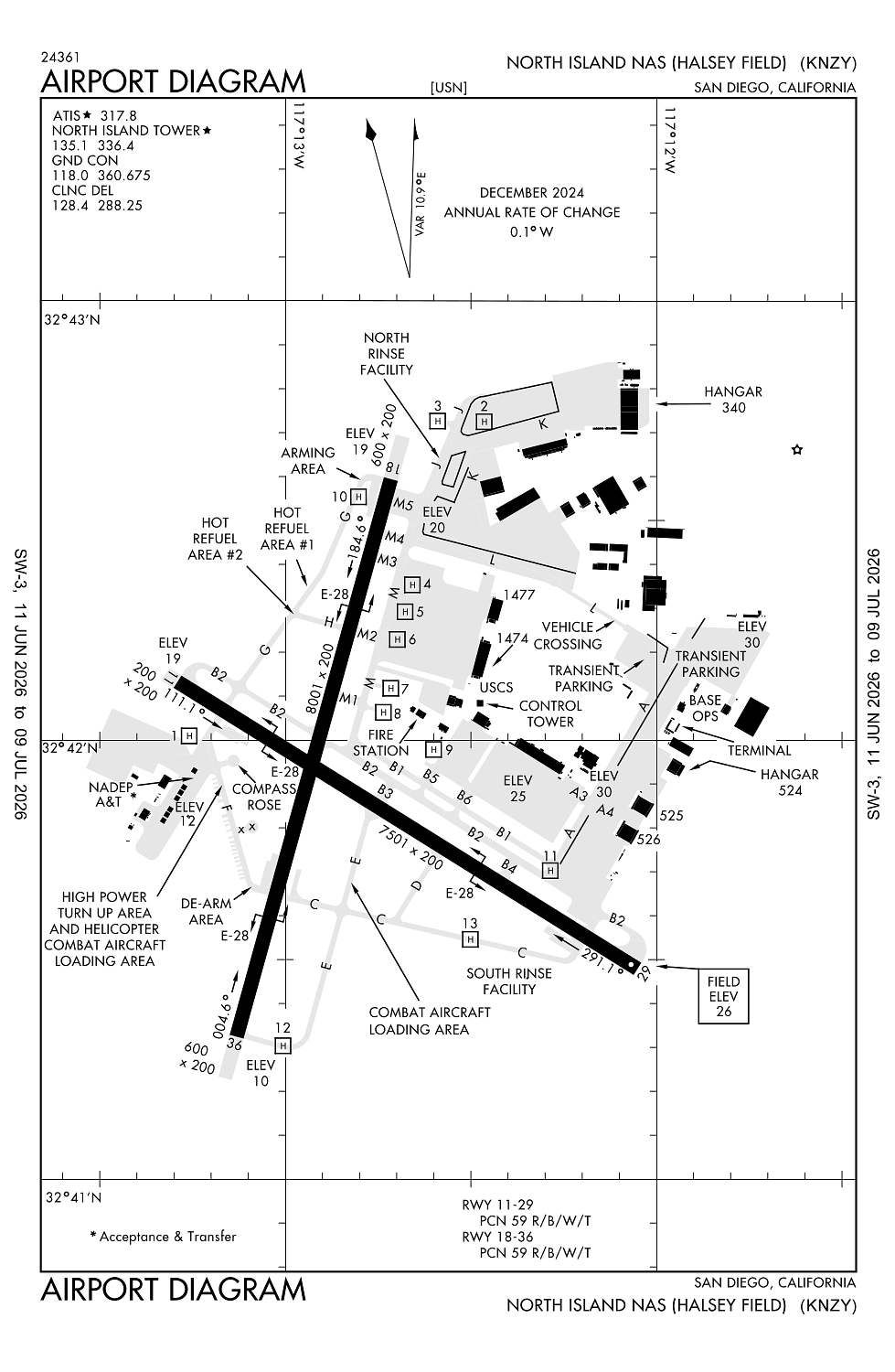
Runway 18/36:
8,001ft
Runway 11/29:
7,501ft
Access: Private to everyone
This is a military facility.
Current Weather — VFR
-
Weather data is strictly informational and not for flight planning purposes.
-
METAR2026-07-20 16:52:00 PDT
Ceiling: 15,000ft Wind: 300° @ 6kt Temperature: 75°F Dewpoint: 64°F Weather: N/A Visbility: 10SM Clouds: Broken @ 15,000ft, Broken @ 20,000ft Raw:METAR KNZY 202352Z 30006KT 10SM BKN150 BKN200 24/18 A2988 RMK AO2 SLP119 T02390183 10267 20239 58009 $ -
TAF2026-07-20 16:00:00 PDT – 2026-07-20 20:00:00 PDT
Ceiling: 15,000ft Wind: 300° @ 8kt Weather: N/A Visbility: 6SM Clouds: Broken @ 15,000ft, Broken @ 20,000ft Raw:TAF KNZY 202300Z 2023/2123 30008KT 9999 BKN150 BKN200 QNH2985NS FM210300 VRB04KT 9999 SCT012 BKN150 BKN200 QNH2990INS TEMPO 2108/2114 BKN012 FM211800 28010KT 9999 SCT150 SCT200 QNH2992INS TX26/2122Z TN18/2113Z FS30160 -
TAF2026-07-20 20:00:00 PDT – 2026-07-21 11:00:00 PDT
Ceiling: 15,000ft Wind: Variable Weather: N/A Visbility: 6SM Clouds: Scattered @ 1,200ft, Broken @ 15,000ft, Broken @ 20,000ft Raw:TAF KNZY 202300Z 2023/2123 30008KT 9999 BKN150 BKN200 QNH2985NS FM210300 VRB04KT 9999 SCT012 BKN150 BKN200 QNH2990INS TEMPO 2108/2114 BKN012 FM211800 28010KT 9999 SCT150 SCT200 QNH2992INS TX26/2122Z TN18/2113Z FS30160 -
TAF2026-07-21 01:00:00 PDT – 2026-07-21 07:00:00 PDT
Ceiling: 1,200ft Wind: 000° @ kt Weather: N/A Visbility: SM Clouds: Broken @ 1,200ft Raw:TAF KNZY 202300Z 2023/2123 30008KT 9999 BKN150 BKN200 QNH2985NS FM210300 VRB04KT 9999 SCT012 BKN150 BKN200 QNH2990INS TEMPO 2108/2114 BKN012 FM211800 28010KT 9999 SCT150 SCT200 QNH2992INS TX26/2122Z TN18/2113Z FS30160 -
TAF2026-07-21 11:00:00 PDT – 2026-07-21 16:00:00 PDT
Ceiling: Sky clear Wind: 280° @ 10kt Weather: N/A Visbility: 6SM Clouds: Scattered @ 15,000ft, Scattered @ 20,000ft Raw:TAF KNZY 202300Z 2023/2123 30008KT 9999 BKN150 BKN200 QNH2985NS FM210300 VRB04KT 9999 SCT012 BKN150 BKN200 QNH2990INS TEMPO 2108/2114 BKN012 FM211800 28010KT 9999 SCT150 SCT200 QNH2992INS TX26/2122Z TN18/2113Z FS30160
Click/tap to add an annotation marker to the map
No webcams added yet.
Remarks
- Misc: vip/logistic flt ctc base ops prior to ldg.
- Tfc pat: use max exterior lgt blw 10,000' within 10 nm. all tran acft ltd to full stop only. touch-and-go/lo apch not avbl. tran acft section apch not auth. reduced rwy separation std in eff usn/usmc acft.
- Caution: extv vfr copter opr sfc-500' vcnty arpt and sfc-2000' 8 nm se. lgt civ acft climb/descend thru ry 29 final apch crs byd 6 dme enter/dep san diego class b airspace vfr corridor. avoid cntrline lgt dur ry 29 or ry 36 arrestment to prevent tailhook bounce. hvy veh tfc cross twy l and twy a.
- Fuel: exp reful delays. 100ll, j5.
- Fluid: sp presair.
Comments