Pirep is a free, collaborative database of all public and private airports. All pilots are welcome to contribute their local knowledge to any airport, no registration required.


Public
Undocumented
METAR / TAF
Edit Tags
No upcoming events. Is anything happening here soon?
Airport Statistics
- Airport map annotations
- Webcam links
- Local flying clubs
Location:
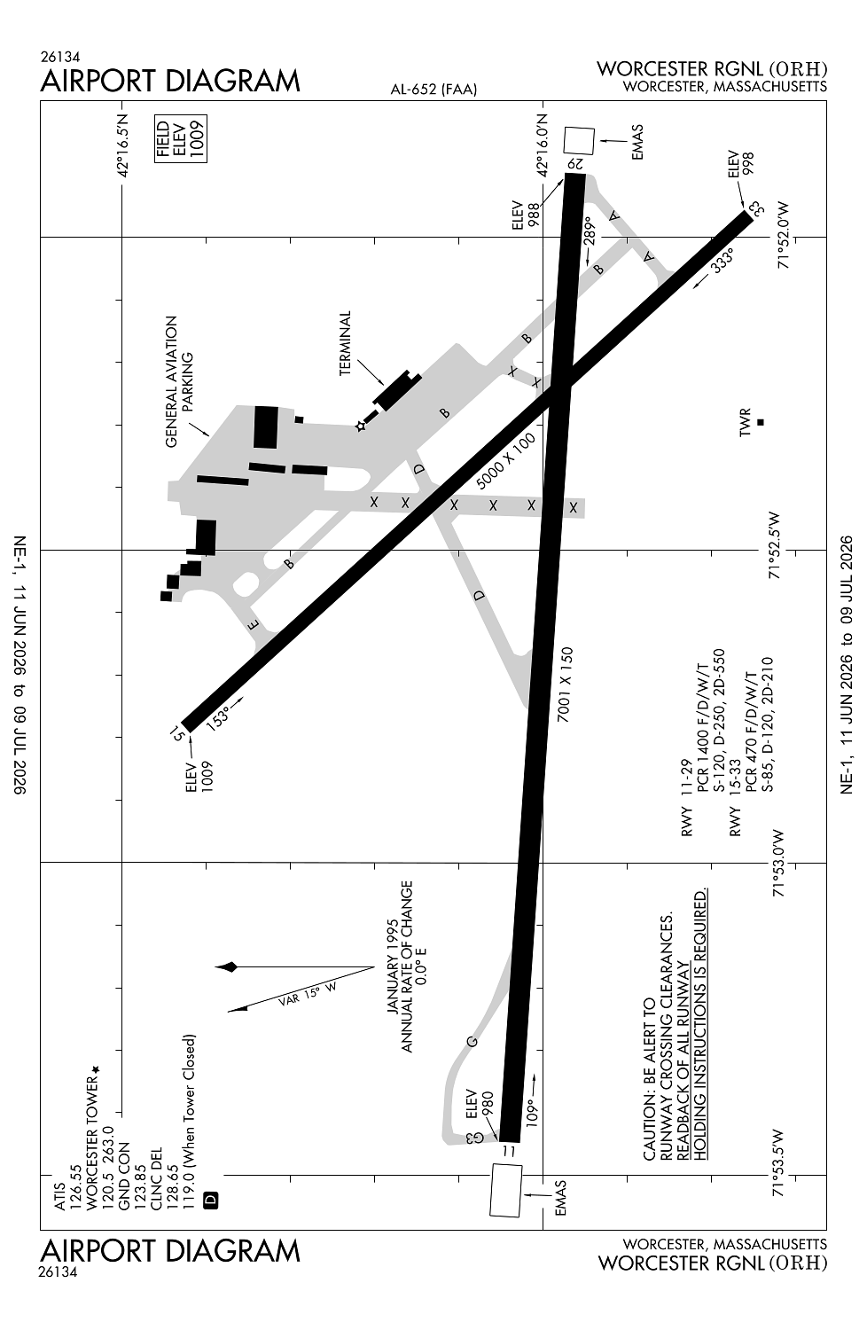
Worcester, MA
Elevation:
1,009ft
Sectional:
New York
Activation date:
Feb 1946
Fuel:
100LL, A (prices)
Runway 11/29:
7,001ft
Runway 15/33:
5,000ft
Access: Open to the public
Current Weather — VFR
-
Weather data is strictly informational and not for flight planning purposes.
-
METAR2026-07-16 04:54:00 EDT
Ceiling: Sky clear Wind: 270° @ 8kt Temperature: 62°F Dewpoint: 55°F Weather: Haze Visbility: 10SM Raw:METAR KORH 160854Z AUTO 27008KT 10SM HZ CLR 17/13 A2990 RMK AO2 SLP121 T01720133 57001 $ -
TAF2026-07-16 02:00:00 EDT – 2026-07-16 11:00:00 EDT
Ceiling: 13,000ft Wind: 280° @ 11kt Weather: Smoke Visbility: 6SM Clouds: Broken @ 13,000ft Raw:TAF KORH 160520Z 1606/1706 28011KT 6SM FU BKN130 FM161500 27014G27KT 4SM FU BKN130 FM170000 30007KT 6SM FU BKN130 FM170200 31005KT P6SM FEW130 SCT250 -
TAF2026-07-16 11:00:00 EDT – 2026-07-16 20:00:00 EDT
Ceiling: 13,000ft Wind: 270° @ 14kt, gusts 27kt Weather: Smoke Visbility: 4SM Clouds: Broken @ 13,000ft Raw:TAF KORH 160520Z 1606/1706 28011KT 6SM FU BKN130 FM161500 27014G27KT 4SM FU BKN130 FM170000 30007KT 6SM FU BKN130 FM170200 31005KT P6SM FEW130 SCT250 -
TAF2026-07-16 20:00:00 EDT – 2026-07-16 22:00:00 EDT
Ceiling: 13,000ft Wind: 300° @ 7kt Weather: Smoke Visbility: 6SM Clouds: Broken @ 13,000ft Raw:TAF KORH 160520Z 1606/1706 28011KT 6SM FU BKN130 FM161500 27014G27KT 4SM FU BKN130 FM170000 30007KT 6SM FU BKN130 FM170200 31005KT P6SM FEW130 SCT250 -
TAF2026-07-16 22:00:00 EDT – 2026-07-17 02:00:00 EDT
Ceiling: Sky clear Wind: 310° @ 5kt Weather: N/A Visbility: 6SM Clouds: Few @ 13,000ft, Scattered @ 25,000ft Raw:TAF KORH 160520Z 1606/1706 28011KT 6SM FU BKN130 FM161500 27014G27KT 4SM FU BKN130 FM170000 30007KT 6SM FU BKN130 FM170200 31005KT P6SM FEW130 SCT250
Click/tap to add an annotation marker to the map
No webcams added yet.
Remarks
- Filed for record purposes only.
- Wildlife & birds on & invof arpt.
- Durg sn removal ops, 30 min ppr, freq 120.50 durg twr hrs, freq 119.0 durg non-twr hrs or call 508-799-1325.
- Use ctn for arpt vehicles mnt ctaf & operg on arpt durg non-twr hrs.
- Tsnt acft ctc fbo on 122.95 for svcs.
Comments