Pirep is a free, collaborative database of all public and private airports. All pilots are welcome to contribute their local knowledge to any airport, no registration required.
Undocumented
METAR / TAF
Edit Tags
No upcoming events. Is anything happening here soon?
Airport Statistics
- Webcam links
- Tags
- Local flying clubs
Location:
Panama City, FL
Elevation:
17ft
Sectional:
New Orleans
Fuel:
A++ (prices)
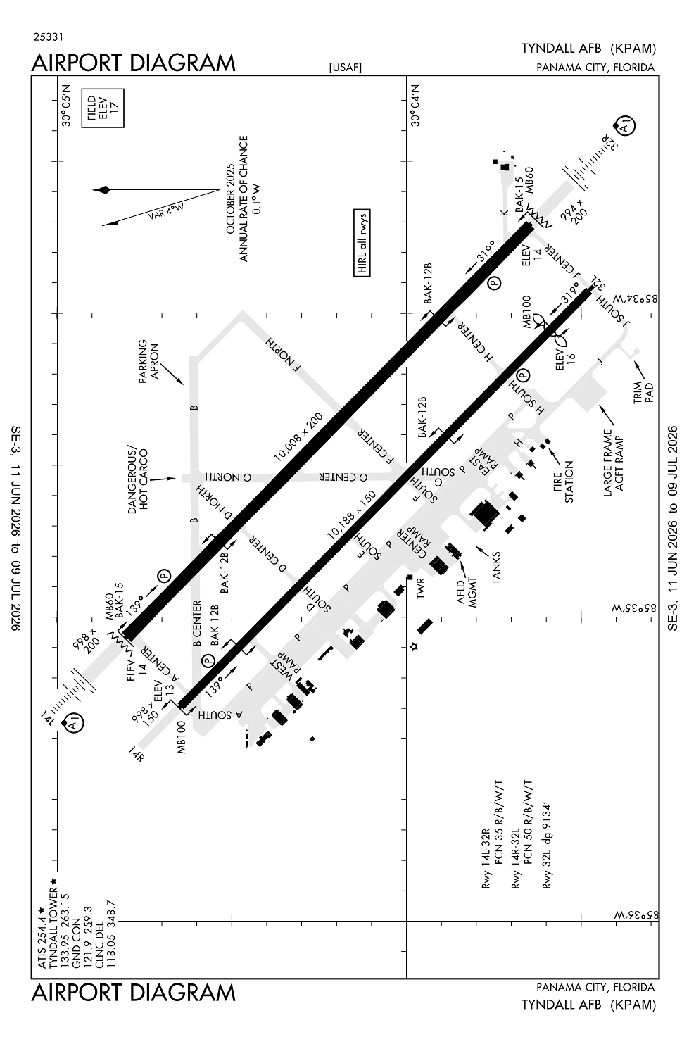
Runway 14R/32L:
10,107ft
Runway 14L/32R:
10,008ft
Access: Private to everyone
This is a military facility.
Current Weather — VFR
-
Weather data is strictly informational and not for flight planning purposes.
-
METAR2026-07-20 07:55:00 CDT
Ceiling: 8,000ft Wind: 050° @ 10kt, gusts 17kt Temperature: 79°F Dewpoint: 74°F Weather: N/A Visbility: 10SM Clouds: Few @ 2,700ft, Scattered @ 5,000ft, Broken @ 8,000ft Raw:METAR KPAM 201255Z 05010G17KT 10SM FEW027 SCT050 BKN080 26/24 A2985 RMK AO2A SLP111 T02640236 $ -
TAF2026-07-20 06:00:00 CDT – 2026-07-20 09:00:00 CDT
Ceiling: 8,000ft Wind: 050° @ 12kt, gusts 18kt Weather: Showers in vicinity Visbility: 6SM Clouds: Scattered @ 1,500ft, Broken @ 8,000ft, Broken @ 15,000ft Raw:TAF KPAM 201100Z 2011/2117 05012G18KT 9999 VCSH SCT015 BKN080 BKN150 QNH2984INS TEMPO 2011/2015 8000 SHRA VCTS SCT015CB BECMG 2014/2015 06012G20KT 8000 SHRA VCTS BKN020CB BKN080 OVC120 QNH2979INS TEMPO 2017/2021 05015G35KT 3200 TSRA BKN012CB OVC080 BECMG 2023/2101 05015G26KT 6000 -TSRA BKN015CB OVC080 QNH2973INS TEMPO 2101/2105 05020G35KT 3200 +TSRA OVC010CB BECMG 2109/2111 06015G26KT 8000 SHRA VCTS BKN015CB OVC080 QNH2972INS TEMPO 2111/2115 08020G30KT 3200 TSRA BKN010CB BECMG 2116/2117 10020G35KT 3200 TSRA OVC008CB QNH2972INS TX25/2011Z TN30/2019Z -
TAF2026-07-20 06:00:00 CDT – 2026-07-20 10:00:00 CDT
Ceiling: Sky clear Wind: 000° @ kt Weather: Rain showers, thunderstorm in vicinity Visbility: 4SM Clouds: Scattered @ 1,500ft Raw:TAF KPAM 201100Z 2011/2117 05012G18KT 9999 VCSH SCT015 BKN080 BKN150 QNH2984INS TEMPO 2011/2015 8000 SHRA VCTS SCT015CB BECMG 2014/2015 06012G20KT 8000 SHRA VCTS BKN020CB BKN080 OVC120 QNH2979INS TEMPO 2017/2021 05015G35KT 3200 TSRA BKN012CB OVC080 BECMG 2023/2101 05015G26KT 6000 -TSRA BKN015CB OVC080 QNH2973INS TEMPO 2101/2105 05020G35KT 3200 +TSRA OVC010CB BECMG 2109/2111 06015G26KT 8000 SHRA VCTS BKN015CB OVC080 QNH2972INS TEMPO 2111/2115 08020G30KT 3200 TSRA BKN010CB BECMG 2116/2117 10020G35KT 3200 TSRA OVC008CB QNH2972INS TX25/2011Z TN30/2019Z -
TAF2026-07-20 09:00:00 CDT – 2026-07-20 18:00:00 CDT
Ceiling: 2,000ft Wind: 060° @ 12kt, gusts 20kt Weather: Rain showers, thunderstorm in vicinity Visbility: 4SM Clouds: Broken @ 2,000ft, Broken @ 8,000ft, Overcast @ 12,000ft Raw:TAF KPAM 201100Z 2011/2117 05012G18KT 9999 VCSH SCT015 BKN080 BKN150 QNH2984INS TEMPO 2011/2015 8000 SHRA VCTS SCT015CB BECMG 2014/2015 06012G20KT 8000 SHRA VCTS BKN020CB BKN080 OVC120 QNH2979INS TEMPO 2017/2021 05015G35KT 3200 TSRA BKN012CB OVC080 BECMG 2023/2101 05015G26KT 6000 -TSRA BKN015CB OVC080 QNH2973INS TEMPO 2101/2105 05020G35KT 3200 +TSRA OVC010CB BECMG 2109/2111 06015G26KT 8000 SHRA VCTS BKN015CB OVC080 QNH2972INS TEMPO 2111/2115 08020G30KT 3200 TSRA BKN010CB BECMG 2116/2117 10020G35KT 3200 TSRA OVC008CB QNH2972INS TX25/2011Z TN30/2019Z -
TAF2026-07-20 12:00:00 CDT – 2026-07-20 16:00:00 CDT
Ceiling: 1,200ft Wind: 050° @ 15kt, gusts 35kt Weather: Thunderstorm rain Visbility: 1SM Clouds: Broken @ 1,200ft, Overcast @ 8,000ft Raw:TAF KPAM 201100Z 2011/2117 05012G18KT 9999 VCSH SCT015 BKN080 BKN150 QNH2984INS TEMPO 2011/2015 8000 SHRA VCTS SCT015CB BECMG 2014/2015 06012G20KT 8000 SHRA VCTS BKN020CB BKN080 OVC120 QNH2979INS TEMPO 2017/2021 05015G35KT 3200 TSRA BKN012CB OVC080 BECMG 2023/2101 05015G26KT 6000 -TSRA BKN015CB OVC080 QNH2973INS TEMPO 2101/2105 05020G35KT 3200 +TSRA OVC010CB BECMG 2109/2111 06015G26KT 8000 SHRA VCTS BKN015CB OVC080 QNH2972INS TEMPO 2111/2115 08020G30KT 3200 TSRA BKN010CB BECMG 2116/2117 10020G35KT 3200 TSRA OVC008CB QNH2972INS TX25/2011Z TN30/2019Z -
TAF2026-07-20 18:00:00 CDT – 2026-07-21 04:00:00 CDT
Ceiling: 1,500ft Wind: 050° @ 15kt, gusts 26kt Weather: Light thunderstorm rain Visbility: 3SM Clouds: Broken @ 1,500ft, Overcast @ 8,000ft Raw:TAF KPAM 201100Z 2011/2117 05012G18KT 9999 VCSH SCT015 BKN080 BKN150 QNH2984INS TEMPO 2011/2015 8000 SHRA VCTS SCT015CB BECMG 2014/2015 06012G20KT 8000 SHRA VCTS BKN020CB BKN080 OVC120 QNH2979INS TEMPO 2017/2021 05015G35KT 3200 TSRA BKN012CB OVC080 BECMG 2023/2101 05015G26KT 6000 -TSRA BKN015CB OVC080 QNH2973INS TEMPO 2101/2105 05020G35KT 3200 +TSRA OVC010CB BECMG 2109/2111 06015G26KT 8000 SHRA VCTS BKN015CB OVC080 QNH2972INS TEMPO 2111/2115 08020G30KT 3200 TSRA BKN010CB BECMG 2116/2117 10020G35KT 3200 TSRA OVC008CB QNH2972INS TX25/2011Z TN30/2019Z -
TAF2026-07-20 20:00:00 CDT – 2026-07-21 00:00:00 CDT
Ceiling: 1,000ft Wind: 050° @ 20kt, gusts 35kt Weather: Heavy thunderstorm rain Visbility: 1SM Clouds: Overcast @ 1,000ft Raw:TAF KPAM 201100Z 2011/2117 05012G18KT 9999 VCSH SCT015 BKN080 BKN150 QNH2984INS TEMPO 2011/2015 8000 SHRA VCTS SCT015CB BECMG 2014/2015 06012G20KT 8000 SHRA VCTS BKN020CB BKN080 OVC120 QNH2979INS TEMPO 2017/2021 05015G35KT 3200 TSRA BKN012CB OVC080 BECMG 2023/2101 05015G26KT 6000 -TSRA BKN015CB OVC080 QNH2973INS TEMPO 2101/2105 05020G35KT 3200 +TSRA OVC010CB BECMG 2109/2111 06015G26KT 8000 SHRA VCTS BKN015CB OVC080 QNH2972INS TEMPO 2111/2115 08020G30KT 3200 TSRA BKN010CB BECMG 2116/2117 10020G35KT 3200 TSRA OVC008CB QNH2972INS TX25/2011Z TN30/2019Z -
TAF2026-07-21 04:00:00 CDT – 2026-07-21 11:00:00 CDT
Ceiling: 1,500ft Wind: 060° @ 15kt, gusts 26kt Weather: Rain showers, thunderstorm in vicinity Visbility: 4SM Clouds: Broken @ 1,500ft, Overcast @ 8,000ft Raw:TAF KPAM 201100Z 2011/2117 05012G18KT 9999 VCSH SCT015 BKN080 BKN150 QNH2984INS TEMPO 2011/2015 8000 SHRA VCTS SCT015CB BECMG 2014/2015 06012G20KT 8000 SHRA VCTS BKN020CB BKN080 OVC120 QNH2979INS TEMPO 2017/2021 05015G35KT 3200 TSRA BKN012CB OVC080 BECMG 2023/2101 05015G26KT 6000 -TSRA BKN015CB OVC080 QNH2973INS TEMPO 2101/2105 05020G35KT 3200 +TSRA OVC010CB BECMG 2109/2111 06015G26KT 8000 SHRA VCTS BKN015CB OVC080 QNH2972INS TEMPO 2111/2115 08020G30KT 3200 TSRA BKN010CB BECMG 2116/2117 10020G35KT 3200 TSRA OVC008CB QNH2972INS TX25/2011Z TN30/2019Z -
TAF2026-07-21 06:00:00 CDT – 2026-07-21 10:00:00 CDT
Ceiling: 1,000ft Wind: 080° @ 20kt, gusts 30kt Weather: Thunderstorm rain Visbility: 1SM Clouds: Broken @ 1,000ft Raw:TAF KPAM 201100Z 2011/2117 05012G18KT 9999 VCSH SCT015 BKN080 BKN150 QNH2984INS TEMPO 2011/2015 8000 SHRA VCTS SCT015CB BECMG 2014/2015 06012G20KT 8000 SHRA VCTS BKN020CB BKN080 OVC120 QNH2979INS TEMPO 2017/2021 05015G35KT 3200 TSRA BKN012CB OVC080 BECMG 2023/2101 05015G26KT 6000 -TSRA BKN015CB OVC080 QNH2973INS TEMPO 2101/2105 05020G35KT 3200 +TSRA OVC010CB BECMG 2109/2111 06015G26KT 8000 SHRA VCTS BKN015CB OVC080 QNH2972INS TEMPO 2111/2115 08020G30KT 3200 TSRA BKN010CB BECMG 2116/2117 10020G35KT 3200 TSRA OVC008CB QNH2972INS TX25/2011Z TN30/2019Z -
TAF2026-07-21 11:00:00 CDT – 2026-07-21 12:00:00 CDT
Ceiling: 800ft Wind: 100° @ 20kt, gusts 35kt Weather: Thunderstorm rain Visbility: 1SM Clouds: Overcast @ 800ft Raw:TAF KPAM 201100Z 2011/2117 05012G18KT 9999 VCSH SCT015 BKN080 BKN150 QNH2984INS TEMPO 2011/2015 8000 SHRA VCTS SCT015CB BECMG 2014/2015 06012G20KT 8000 SHRA VCTS BKN020CB BKN080 OVC120 QNH2979INS TEMPO 2017/2021 05015G35KT 3200 TSRA BKN012CB OVC080 BECMG 2023/2101 05015G26KT 6000 -TSRA BKN015CB OVC080 QNH2973INS TEMPO 2101/2105 05020G35KT 3200 +TSRA OVC010CB BECMG 2109/2111 06015G26KT 8000 SHRA VCTS BKN015CB OVC080 QNH2972INS TEMPO 2111/2115 08020G30KT 3200 TSRA BKN010CB BECMG 2116/2117 10020G35KT 3200 TSRA OVC008CB QNH2972INS TX25/2011Z TN30/2019Z
Click/tap to add an annotation marker to the map
No webcams added yet.
Remarks
- Jasu: (c-26) (md-3) (mc-11) (m32a-10)
- Fluid: sp presair lhox lox
- Oil: o-148 soap
- Rstd: 48 hr ppr - airfield mgmt dsn 523-4244/45, c850-283-4244/45; ppr valid 1 hr +/- eta; early/late arr/dep must recoordinate; c130 & lrgr provide amops 48 hr prior coord for acft ops rqrg barrier removal.
- Caution: drone launch & recovery 2.5 sm & 3 sm sse of main arpt; extv trng jet tfc 40 nm e; night wx obs limitations due to high intst stadium lgts.
Comments