Pirep is a free, collaborative database of all public and private airports. All pilots are welcome to contribute their local knowledge to any airport, no registration required.

Public
Undocumented
METAR / TAF
Edit Tags
No upcoming events. Is anything happening here soon?
Airport Statistics
- Webcam links
- Transient parking location
- Crew car availability
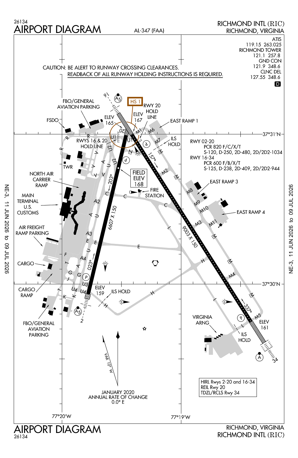
Location:
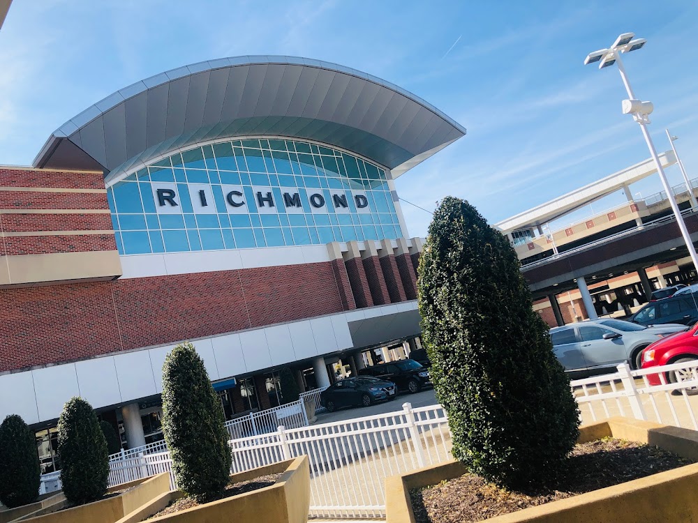
Richmond, VA
Elevation:
167ft
Sectional:
Washington
Activation date:
Dec 1931
Fuel:
100LL, A (prices)
Runway 16/34:
9,003ft
Runway 02/20:
6,607ft
Access: Open to the public
Current Weather — VFR
-
Weather data is strictly informational and not for flight planning purposes.
-
METAR2026-07-20 23:54:00 EDT
Ceiling: 30,000ft Wind: 190° @ 4kt Temperature: 75°F Dewpoint: 73°F Weather: N/A Visbility: 7SM Clouds: Few @ 900ft, Broken @ 30,000ft Raw:METAR KRIC 210354Z 19004KT 7SM FEW009 BKN300 24/23 A2993 RMK AO2 SLP137 T02440233 -
TAF2026-07-20 20:00:00 EDT – 2026-07-21 02:00:00 EDT
Ceiling: Sky clear Wind: 150° @ 7kt Weather: N/A Visbility: 6SM Clouds: Scattered @ 7,000ft Raw:TAF KRIC 202339Z 2100/2124 15007KT P6SM SCT070 FM210600 18005KT 4SM BR VCSH BKN015 FM210900 18006KT 3SM BR BKN010 FM211300 21011KT P6SM SCT050 FM211900 22013G21KT 5SM -SHRA BKN060 PROB30 2120/2124 VRB15G35KT 2SM TSRA OVC035CB -
TAF2026-07-21 02:00:00 EDT – 2026-07-21 05:00:00 EDT
Ceiling: 1,500ft Wind: 180° @ 5kt Weather: Mist, showers in vicinity Visbility: 4SM Clouds: Broken @ 1,500ft Raw:TAF KRIC 202339Z 2100/2124 15007KT P6SM SCT070 FM210600 18005KT 4SM BR VCSH BKN015 FM210900 18006KT 3SM BR BKN010 FM211300 21011KT P6SM SCT050 FM211900 22013G21KT 5SM -SHRA BKN060 PROB30 2120/2124 VRB15G35KT 2SM TSRA OVC035CB -
TAF2026-07-21 05:00:00 EDT – 2026-07-21 09:00:00 EDT
Ceiling: 1,000ft Wind: 180° @ 6kt Weather: Mist Visbility: 3SM Clouds: Broken @ 1,000ft Raw:TAF KRIC 202339Z 2100/2124 15007KT P6SM SCT070 FM210600 18005KT 4SM BR VCSH BKN015 FM210900 18006KT 3SM BR BKN010 FM211300 21011KT P6SM SCT050 FM211900 22013G21KT 5SM -SHRA BKN060 PROB30 2120/2124 VRB15G35KT 2SM TSRA OVC035CB -
TAF2026-07-21 09:00:00 EDT – 2026-07-21 15:00:00 EDT
Ceiling: Sky clear Wind: 210° @ 11kt Weather: N/A Visbility: 6SM Clouds: Scattered @ 5,000ft Raw:TAF KRIC 202339Z 2100/2124 15007KT P6SM SCT070 FM210600 18005KT 4SM BR VCSH BKN015 FM210900 18006KT 3SM BR BKN010 FM211300 21011KT P6SM SCT050 FM211900 22013G21KT 5SM -SHRA BKN060 PROB30 2120/2124 VRB15G35KT 2SM TSRA OVC035CB -
TAF2026-07-21 15:00:00 EDT – 2026-07-21 20:00:00 EDT
Ceiling: 6,000ft Wind: 220° @ 13kt, gusts 21kt Weather: Light rain showers Visbility: 5SM Clouds: Broken @ 6,000ft Raw:TAF KRIC 202339Z 2100/2124 15007KT P6SM SCT070 FM210600 18005KT 4SM BR VCSH BKN015 FM210900 18006KT 3SM BR BKN010 FM211300 21011KT P6SM SCT050 FM211900 22013G21KT 5SM -SHRA BKN060 PROB30 2120/2124 VRB15G35KT 2SM TSRA OVC035CB -
TAF2026-07-21 16:00:00 EDT – 2026-07-21 20:00:00 EDT
Ceiling: 3,500ft Wind: Variable, gusts 35kt Weather: Thunderstorm rain Visbility: 2SM Clouds: Overcast @ 3,500ft Raw:TAF KRIC 202339Z 2100/2124 15007KT P6SM SCT070 FM210600 18005KT 4SM BR VCSH BKN015 FM210900 18006KT 3SM BR BKN010 FM211300 21011KT P6SM SCT050 FM211900 22013G21KT 5SM -SHRA BKN060 PROB30 2120/2124 VRB15G35KT 2SM TSRA OVC035CB
Click/tap to add an annotation marker to the map
No webcams added yet.
Remarks
- Existed prior to 1959.
- Arff index d/e avbl upon request.
- No turbojet acft practice ldgs 2200-0700.
- Bird act invof all rwys & twys & invof arpt.
- Acr apron clsd to unsked acft weighing under 35000 lbs.
Comments